


j06_2

DUPORT16
User
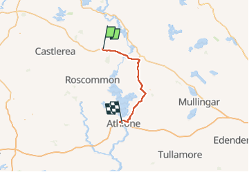

Length
69 km

Max alt
90 m

Uphill gradient
433 m
Km-Effort
74 km

Min alt
34 m

Downhill gradient
441 m
Boucle
No
Creation date :
2023-05-29 11:22:22.981
Updated on :
2023-05-29 12:33:24.16
1h10
Difficulty : Very easy

FREE GPS app for hiking
 SityTrail
IGN / Geographical institutes
SityTrail World
The world is yours!
About
Trail Car of 69 km to be discovered at Unknown, County Roscommon, Boyle Municipal District. This trail is proposed by DUPORT16.
Positioning
Country:
Ireland
Region :
Unknown
Department/Province :
County Roscommon
Municipality :
Boyle Municipal District
Location:
Strokestown ED
Start:(Dec)
Start:(UTM)
559407 ; 5958986 (29U) N.
Comments
Trails nearby