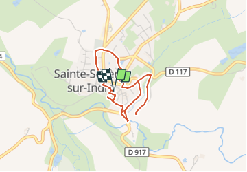
![](/images/other/stat-length.png)
![Trail Walking Sainte-Sévère-sur-Indre - Les lieux de tournage de Jour de Fête & le patrimoine de la ville (circuit long) - Photo](https://media.geolcdn.com/t/1900/400/ext.pjpeg?maxdim=2&url=https%3A%2F%2Fstatic1.geolcdn.com%2Fsiteimages%2Fupload%2Ffiles%2F1553511878bg_sport_marche.png)
Les lieux de tournage de Jour de Fête & le patrimoine de la ville (circuit long)
fanthou
User
![Length](/images/other/stat-length.png)
![Max alt](https://static1.geolcdn.com/siteimages/upload/files/1508320355ic_sort_altitude_max_24dp.png)
![Uphill gradient](https://static1.geolcdn.com/siteimages/upload/files/1508320355ic_sort_den_pos_24dp.png)
![Km-Effort](/images/other/stat-length.png)
![Min alt](https://static1.geolcdn.com/siteimages/upload/files/1508320355ic_sort_altitude_min_24dp.png)
![Downhill gradient](https://static1.geolcdn.com/siteimages/upload/files/1508320355ic_sort_den_neg_24dp.png)
![Boucle](https://static1.geolcdn.com/siteimages/upload/files/16400158638029165_repeat_loop_refresh_sync_direction_icon.png)
![Walking](https://static1.geolcdn.com/sitytour/trail-icons/101.png)
1h40
Difficulty : Easy
![Scan this QR Code to open this trail in the SityTrail application](https://capi.geolives.com/qq0zvz2zws4bq2lad0pu/sitytour/trails/3675991/qr.png?size=200)
FREE GPS app for hiking
About
Trail Walking of 6 km to be discovered at Centre-Loire Valley, Indre, Sainte-Sévère-sur-Indre. This trail is proposed by fanthou.
Description
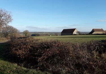
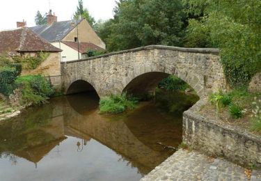
Le pittoresque village de Sainte-Sévère se situe à quelques kilomètres de la source de l’Indre, dans un paysage vallonné annonçant le Limousin tout proche. Il doit son nom à une religieuse allemande du 7ème siècle, venue fonder un petit monastère au pied du village. C’est autour du château que les premières maisons se sont regroupées, autour de l’an mil, pour donner naissance au bourg. Mentionnée pour la première fois vers 1050, Sainte-Sévère a grandi rapidement, devenant une ville fortifiée sur la frontière sud du Berry. L’important château, attaqué au moins six fois en cinq siècles, a joué un rôle important pendant la guerre de Cent Ans: occupé par surprise en 1370 par les Anglais, il devint l’une de leurs principales places fortes dans le centre de la France, avant d’être repris par l’armée du roi de France à l’issue d’un siège et d’un assaut restés fameux, en juillet 1372. A nouveau prise et pillée en 1435, la ville s’est reconstruite largement à la fin du Moyen Age: bien des maisons encore conservées dans la vieille ville datent de cette période, ainsi que la porte fortifiée et le donjon du château. Les siècles suivants ont laissé de nombreux témoignages à découvrir à travers la ville: la croix et la halle de la place du marché, de belles maisons des 17e et 18e siècles… Enfin, les dernières grandes transformations du village furent réalisées entre 1830 et 1880, avec la création de nouvelles rues et l’aménagement du champ de foire, la construction de l’église, de la mairie et des écoles
Positioning
Comments
Trails nearby
![Trail Hybrid bike Pouligny-Notre-Dame - autour des Dryades - Photo](https://media.geolcdn.com/t/375/260/2a88c383-2d3f-4c0b-a2e0-0f424360315b.jpg&format=jpg&maxdim=2)
![Hybrid bike Hybrid bike](https://static1.geolcdn.com/sitytour/trail-icons/203.png)
Hybrid bike
![](/images/other/stat-length.png)
![](https://static1.geolcdn.com/siteimages/upload/files/16400158638029165_repeat_loop_refresh_sync_direction_icon.png)
![Trail Walking Sainte-Sévère-sur-Indre - Sur les pas des Maîtres Sonneurs Variante 1 (Sainte Sévère sur Indre -La Motte-Feuilly) - Photo](https://media.geolcdn.com/t/375/260/ext.jpg?maxdim=2&url=https%3A%2F%2Fservices.sitytrail.com%2FGeolivesWS%2FDownloadMedia.ashx%3FTrailID%3D172464%26Media%3D13825_3.jpg)
![Walking Walking](https://static1.geolcdn.com/sitytour/trail-icons/101.png)
Walking
![](/images/other/stat-length.png)
![](https://static1.geolcdn.com/siteimages/upload/files/16400158638029165_repeat_loop_refresh_sync_direction_icon.png)
![Trail Walking Pouligny-Notre-Dame - Sur les pas des Maîtres Sonneurs (Pouligny-Notre-Dame (Ligny) - La Châtre) - Photo](https://media.geolcdn.com/t/375/260/ext.jpg?maxdim=2&url=https%3A%2F%2Fservices.sitytrail.com%2FGeolivesWS%2FDownloadMedia.ashx%3FTrailID%3D172457%26Media%3D13816_5.jpg)
![Walking Walking](https://static1.geolcdn.com/sitytour/trail-icons/101.png)
Walking
![](/images/other/stat-length.png)
![](https://static1.geolcdn.com/siteimages/upload/files/16400158638029165_repeat_loop_refresh_sync_direction_icon.png)
![Trail Walking Feusines - Circuit pédestre n° 93](https://media.geolcdn.com/t/375/260/ext.jpg?maxdim=2&url=https%3A%2F%2Fstatic1.geolcdn.com%2Fsiteimages%2Fupload%2Ffiles%2F1553511878bg_sport_marche.png)
![Walking Walking](https://static1.geolcdn.com/sitytour/trail-icons/101.png)
Walking
![](/images/other/stat-length.png)
![](https://static1.geolcdn.com/siteimages/upload/files/16400158638029165_repeat_loop_refresh_sync_direction_icon.png)
![Trail Walking Feusines - Circuit pédestre n° 94](https://media.geolcdn.com/t/375/260/ext.jpg?maxdim=2&url=https%3A%2F%2Fstatic1.geolcdn.com%2Fsiteimages%2Fupload%2Ffiles%2F1553511878bg_sport_marche.png)
![Walking Walking](https://static1.geolcdn.com/sitytour/trail-icons/101.png)
Walking
![](/images/other/stat-length.png)
![](https://static1.geolcdn.com/siteimages/upload/files/16400158638029165_repeat_loop_refresh_sync_direction_icon.png)
![Trail Walking Sainte-Sévère-sur-Indre - Circuit pédestre n° 25](https://media.geolcdn.com/t/375/260/ext.jpg?maxdim=2&url=https%3A%2F%2Fstatic1.geolcdn.com%2Fsiteimages%2Fupload%2Ffiles%2F1553511878bg_sport_marche.png)
![Walking Walking](https://static1.geolcdn.com/sitytour/trail-icons/101.png)
Walking
![](/images/other/stat-length.png)
![](https://static1.geolcdn.com/siteimages/upload/files/16400158638029165_repeat_loop_refresh_sync_direction_icon.png)
![Trail Walking Sainte-Sévère-sur-Indre - Étape 3 septembre 2023 - Photo](https://media.geolcdn.com/t/375/260/ext.jpg?maxdim=2&url=https%3A%2F%2Fstatic1.geolcdn.com%2Fsiteimages%2Fupload%2Ffiles%2F1553511878bg_sport_marche.png)
![Walking Walking](https://static1.geolcdn.com/sitytour/trail-icons/101.png)
Walking
![](/images/other/stat-length.png)
![](https://static1.geolcdn.com/siteimages/upload/files/16400158638029165_repeat_loop_refresh_sync_direction_icon.png)
![Trail Walking Sazeray - parcours_1395030 - Photo](https://media.geolcdn.com/t/375/260/ext.jpg?maxdim=2&url=https%3A%2F%2Fstatic1.geolcdn.com%2Fsiteimages%2Fupload%2Ffiles%2F1553511878bg_sport_marche.png)
![Walking Walking](https://static1.geolcdn.com/sitytour/trail-icons/101.png)
Walking
![](/images/other/stat-length.png)
![](https://static1.geolcdn.com/siteimages/upload/files/16400158638029165_repeat_loop_refresh_sync_direction_icon.png)
![Trail Walking Vigoulant - Le mery - Photo](https://media.geolcdn.com/t/375/260/ext.jpg?maxdim=2&url=https%3A%2F%2Fstatic1.geolcdn.com%2Fsiteimages%2Fupload%2Ffiles%2F1553511878bg_sport_marche.png)
![Walking Walking](https://static1.geolcdn.com/sitytour/trail-icons/101.png)
Walking
![](/images/other/stat-length.png)
![](https://static1.geolcdn.com/siteimages/upload/files/16400158638029165_repeat_loop_refresh_sync_direction_icon.png)