Trail On foot Montchevrier - Circuit pédestre montcabrien - Photo

Circuit pédestre montcabrien

 fanthou
fanthou

User

© OpenStreetMap contributors
Length
Length
6.2 km
Max alt
Max alt
355 m
Uphill gradient
Uphill gradient
101 m
Km-Effort
Km-Effort  
7.6 km
Min alt
Min alt
285 m
Downhill gradient
Downhill gradient
104 m
Boucle
Boucle
Yes
Creation date :
2023-05-27 09:42:24.685
Updated on :
2023-05-27 09:42:53.739

(0 Reviews)

On foot
On foot
1h42
Difficulty : Easy

Scan this QR Code to open this trail in the SityTrail application

FREE GPS app for hiking

Logo SityTrail SityTrail

IGN / Geographical institutes

Download SityTrail from the App Store Download SityTrail from Google Play

Logo SityTrail SityTrail World

The world is yours!

Download SityTrail from the App Store Download SityTrail from Google Play Download SityTrail on Huawei AppGallery

About

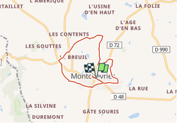
Trail On foot of 6.2 km to be discovered at Centre-Loire Valley, Indre, Montchevrier. This trail is proposed by fanthou.

Description

Circuit autour de la commune de Montchevrier : Terre granitique, terre de bocage, terre de légende... Les occupations préhistoriques puis celtes ont inscrit leurs marques sur ce parcours. Téléchargement du circuit dans la rubrique "accès site web".

Elevation profile

Positioning

Country:
France
Region :
Centre-Loire Valley
Department/Province :
Indre
Municipality :
Montchevrier
Location:
Unknown
Start:(UTM)
403587 ; 5148185 (31T) N.

Trails nearby

Trail Walking Orsennes - Circuit pédestre des étangs - Photo
Walking
fanthou

Walking

Easy
Orsennes, Centre-Loire Valley, Indre, France
7.5 km | 8.4 km-effort
1h 54min
Yes
Trail Other activity Orsennes - Nouveau guide - Photo
Other activity
Yann_H

Other activity

Very easy
Orsennes, Centre-Loire Valley, Indre, France
188 km | 231 km-effort
Unknown
No


Close
My subscriptions