![](/images/other/stat-length.png)
![Trail Walking Ville-sur-Jarnioux - Randonnée du 25/05/2023 à 14:04 - Photo](https://media.geolcdn.com/t/1900/400/ext.pjpeg?maxdim=2&url=https%3A%2F%2Fstatic1.geolcdn.com%2Fsiteimages%2Fupload%2Ffiles%2F1553511878bg_sport_marche.png)
Randonnée du 25/05/2023 à 14:04
Thomasdanielle
User
![Length](/images/other/stat-length.png)
Length
10 km
![Max alt](https://static1.geolcdn.com/siteimages/upload/files/1508320355ic_sort_altitude_max_24dp.png)
Max alt
865 m
![Uphill gradient](https://static1.geolcdn.com/siteimages/upload/files/1508320355ic_sort_den_pos_24dp.png)
Uphill gradient
378 m
![Km-Effort](/images/other/stat-length.png)
Km-Effort
15.1 km
![Min alt](https://static1.geolcdn.com/siteimages/upload/files/1508320355ic_sort_altitude_min_24dp.png)
Min alt
567 m
![Downhill gradient](https://static1.geolcdn.com/siteimages/upload/files/1508320355ic_sort_den_neg_24dp.png)
Downhill gradient
378 m
![Boucle](https://static1.geolcdn.com/siteimages/upload/files/16400158638029165_repeat_loop_refresh_sync_direction_icon.png)
Boucle
Yes
Creation date :
2023-05-26 07:51:53.343
Updated on :
2023-05-26 08:13:48.431
![Walking](https://static1.geolcdn.com/sitytour/trail-icons/101.png)
3h25
Difficulty : Difficult
![Scan this QR Code to open this trail in the SityTrail application](https://capi.geolives.com/qq0zvz2zws4bq2lad0pu/sitytour/trails/3674627/qr.png?size=200)
FREE GPS app for hiking
About
Trail Walking of 10 km to be discovered at Auvergne-Rhône-Alpes, Rhône, Ville-sur-Jarnioux. This trail is proposed by Thomasdanielle.
Description
D/A : Se garer le long de la route D116, Rue du Châtoux au lieu dit "Le Saule d'Oingt" (Ville/sur/Jarnioux) .
Belle randonnée bien ombragée.
Positioning
Country:
France
Region :
Auvergne-Rhône-Alpes
Department/Province :
Rhône
Municipality :
Ville-sur-Jarnioux
Location:
Unknown
Start:(Dec)
Start:(UTM)
622560 ; 5093068 (31T) N.
Comments
Trails nearby
![Trail Walking Ternand - 2022-04-07_21h47m08_Ternand_V2 - Photo](https://media.geolcdn.com/t/375/260/d73b31f3-847d-4c86-9759-810d2e04500a.jpg&format=jpg&maxdim=2)
![Walking Walking](https://static1.geolcdn.com/sitytour/trail-icons/101.png)
2022-04-07_21h47m08_Ternand_V2
Walking
Very difficult
(1)
Ternand,
Auvergne-Rhône-Alpes,
Rhône,
France
![](/images/other/stat-length.png)
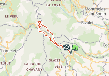
17.8 km | 27 km-effort
6h 7min
![](https://static1.geolcdn.com/siteimages/upload/files/16400158638029165_repeat_loop_refresh_sync_direction_icon.png)
Yes
![Trail Walking Val d'Oingt - Oingt (69) Beaujolais - Photo](https://media.geolcdn.com/t/375/260/ext.jpg?maxdim=2&url=https%3A%2F%2Fservices.sitytrail.com%2FGeolivesWS%2FDownloadMedia.ashx%3FTrailID%3D717640%26Media%3D20161208145812.jpg)
![Walking Walking](https://static1.geolcdn.com/sitytour/trail-icons/101.png)
Oingt (69) Beaujolais
Walking
Very easy
(1)
Val d'Oingt,
Auvergne-Rhône-Alpes,
Rhône,
France
![](/images/other/stat-length.png)
9.3 km | 13.3 km-effort
2h 30min
![](https://static1.geolcdn.com/siteimages/upload/files/16400158638029165_repeat_loop_refresh_sync_direction_icon.png)
Yes
![Trail Electric bike Val d'Oingt - tour dans le beaujolais Oingt - Salles sur Arbuissonnas - Photo](https://media.geolcdn.com/t/375/260/ext.jpg?maxdim=2&url=https%3A%2F%2Fstatic1.geolcdn.com%2Fsiteimages%2Fupload%2Ffiles%2F1524743154velo.jpg)
![Electric bike Electric bike](https://static1.geolcdn.com/sitytour/trail-icons/205.png)
tour dans le beaujolais Oingt - Salles sur Arbuissonnas
Electric bike
Medium
(1)
Val d'Oingt,
Auvergne-Rhône-Alpes,
Rhône,
France
![](/images/other/stat-length.png)
52 km | 68 km-effort
5h 44min
![](https://static1.geolcdn.com/siteimages/upload/files/16400158638029165_repeat_loop_refresh_sync_direction_icon.png)
Yes
![Trail Walking Montmelas-Saint-Sorlin - Col de Saint Bonnet (13-09-18) - Photo](https://media.geolcdn.com/t/375/260/ext.jpg?maxdim=2&url=https%3A%2F%2Fstatic1.geolcdn.com%2Fsiteimages%2Fupload%2Ffiles%2F1553511878bg_sport_marche.png)
![Walking Walking](https://static1.geolcdn.com/sitytour/trail-icons/101.png)
Col de Saint Bonnet (13-09-18)
Walking
Easy
(1)
Montmelas-Saint-Sorlin,
Auvergne-Rhône-Alpes,
Rhône,
France
![](/images/other/stat-length.png)
8.1 km | 11.9 km-effort
2h 29min
![](https://static1.geolcdn.com/siteimages/upload/files/16400158638029165_repeat_loop_refresh_sync_direction_icon.png)
Yes
![Trail Walking Sainte-Paule - Sainte-Paule (13,4 km D. 485 m) - Photo](https://media.geolcdn.com/t/375/260/ext.jpg?maxdim=2&url=https%3A%2F%2Fstatic1.geolcdn.com%2Fsiteimages%2Fupload%2Ffiles%2F1553511878bg_sport_marche.png)
![Walking Walking](https://static1.geolcdn.com/sitytour/trail-icons/101.png)
Sainte-Paule (13,4 km D. 485 m)
Walking
Medium
(1)
Sainte-Paule,
Auvergne-Rhône-Alpes,
Rhône,
France
![](/images/other/stat-length.png)
13.4 km | 19.4 km-effort
4h 9min
![](https://static1.geolcdn.com/siteimages/upload/files/16400158638029165_repeat_loop_refresh_sync_direction_icon.png)
Yes
![Trail Walking Rivolet - Rivolet - Photo](https://media.geolcdn.com/t/375/260/ext.jpg?maxdim=2&url=https%3A%2F%2Fstatic1.geolcdn.com%2Fsiteimages%2Fupload%2Ffiles%2F1553511878bg_sport_marche.png)
![Walking Walking](https://static1.geolcdn.com/sitytour/trail-icons/101.png)
Rivolet
Walking
Medium
(2)
Rivolet,
Auvergne-Rhône-Alpes,
Rhône,
France
![](/images/other/stat-length.png)
11.1 km | 17.2 km-effort
3h 42min
![](https://static1.geolcdn.com/siteimages/upload/files/16400158638029165_repeat_loop_refresh_sync_direction_icon.png)
No
![Walking Walking](https://static1.geolcdn.com/sitytour/trail-icons/101.png)
Saint-Laurent d'Oingt - Oingt, Plus beau Village de France
Walking
Difficult
Val d'Oingt,
Auvergne-Rhône-Alpes,
Rhône,
France
![](/images/other/stat-length.png)
8.8 km | 12.5 km-effort
2h 20min
![](https://static1.geolcdn.com/siteimages/upload/files/16400158638029165_repeat_loop_refresh_sync_direction_icon.png)
Yes
![Trail Walking Val d'Oingt - 69620-Saint-Laurent d'Oingt-Bois d'Oingt : lavoirs, château et coteaux - Photo](https://media.geolcdn.com/t/375/260/f3b7e635-4f2d-4ecb-b5c7-b81cf631e86a.jpg&format=jpg&maxdim=2)
![Walking Walking](https://static1.geolcdn.com/sitytour/trail-icons/101.png)
69620-Saint-Laurent d'Oingt-Bois d'Oingt : lavoirs, château et coteaux
Walking
Medium
Val d'Oingt,
Auvergne-Rhône-Alpes,
Rhône,
France
![](/images/other/stat-length.png)
8 km | 11 km-effort
1h 57min
![](https://static1.geolcdn.com/siteimages/upload/files/16400158638029165_repeat_loop_refresh_sync_direction_icon.png)
Yes
![Trail Walking Theizé - Theizé (11 km - D. 310 m) - Photo](https://media.geolcdn.com/t/375/260/3ec616fb-11b1-40f1-9452-df22023aec06.jpeg&format=jpg&maxdim=2)
![Walking Walking](https://static1.geolcdn.com/sitytour/trail-icons/101.png)
Theizé (11 km - D. 310 m)
Walking
Medium
Theizé,
Auvergne-Rhône-Alpes,
Rhône,
France
![](/images/other/stat-length.png)
11.3 km | 15.5 km-effort
2h 43min
![](https://static1.geolcdn.com/siteimages/upload/files/16400158638029165_repeat_loop_refresh_sync_direction_icon.png)
Yes