![](/images/other/stat-length.png)
![Trail Walking Ainhoa - depuis Dantxaria col des 3 croix col de Zuharreteaco Gorospil - Photo](https://media.geolcdn.com/t/1900/400/ext.pjpeg?maxdim=2&url=https%3A%2F%2Fstatic1.geolcdn.com%2Fsiteimages%2Fupload%2Ffiles%2F1553511878bg_sport_marche.png)
depuis Dantxaria col des 3 croix col de Zuharreteaco Gorospil
DECHAMPD
User
![Length](/images/other/stat-length.png)
![Max alt](https://static1.geolcdn.com/siteimages/upload/files/1508320355ic_sort_altitude_max_24dp.png)
![Uphill gradient](https://static1.geolcdn.com/siteimages/upload/files/1508320355ic_sort_den_pos_24dp.png)
![Km-Effort](/images/other/stat-length.png)
![Min alt](https://static1.geolcdn.com/siteimages/upload/files/1508320355ic_sort_altitude_min_24dp.png)
![Downhill gradient](https://static1.geolcdn.com/siteimages/upload/files/1508320355ic_sort_den_neg_24dp.png)
![Boucle](https://static1.geolcdn.com/siteimages/upload/files/16400158638029165_repeat_loop_refresh_sync_direction_icon.png)
![Walking](https://static1.geolcdn.com/sitytour/trail-icons/101.png)
5h37
Difficulty : Medium
![Scan this QR Code to open this trail in the SityTrail application](https://capi.geolives.com/qq0zvz2zws4bq2lad0pu/sitytour/trails/367067/qr.png?size=200)
FREE GPS app for hiking
About
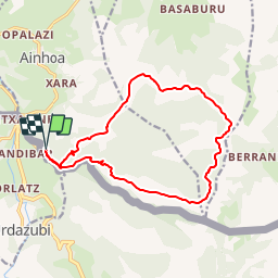
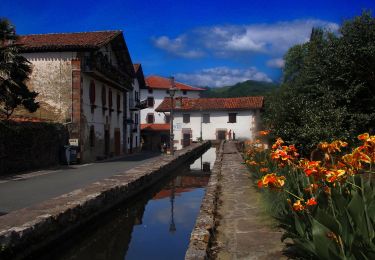
Trail Walking of 15.2 km to be discovered at New Aquitaine, Pyrénées-Atlantiques, Ainhoa. This trail is proposed by DECHAMPD.
Description
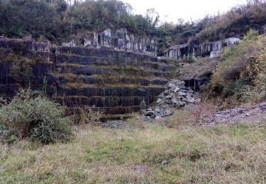
départ au bout chemin Chara Gaichto Nord après carrières à la benta Pantxo au pont canadien Ainhoa/Dantxaria.
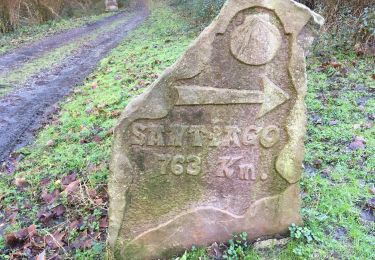
par Perlaenborda, Erramuntenborda, col des 3 croix, GR10, Zuharretako Lepoa,contour du Mont Bizkailuze par l'ouest, Gorospil, Haizagerri, Arotzenborda, BF 74, retour le long Lapitxuriko Erreka.
Points of interest
Positioning
Comments
Trails nearby
![Trail Walking Espelette - Erreka mondarain col des veaux - Photo](https://media.geolcdn.com/t/375/260/3df7f8f7-bc92-4579-aed0-3a855d972fe6.jpg&format=jpg&maxdim=2)
![Walking Walking](https://static1.geolcdn.com/sitytour/trail-icons/101.png)
Walking
![](/images/other/stat-length.png)
![](https://static1.geolcdn.com/siteimages/upload/files/16400158638029165_repeat_loop_refresh_sync_direction_icon.png)
![Trail Running Ainhoa - Ainhoa - L'Erebi - Photo](https://media.geolcdn.com/t/375/260/ext.jpg?maxdim=2&url=https%3A%2F%2Fservices.sitytrail.com%2FGeolivesWS%2FDownloadMedia.ashx%3FTrailID%3D105338%26Media%3D9037_5.jpg)
![Running Running](https://static1.geolcdn.com/sitytour/trail-icons/103.png)
Running
![](/images/other/stat-length.png)
![](https://static1.geolcdn.com/siteimages/upload/files/16400158638029165_repeat_loop_refresh_sync_direction_icon.png)
![Trail Walking Urdazubi/Urdax - urdax - Photo](https://media.geolcdn.com/t/375/260/eb9329a6-8a81-4e34-9565-1e6fabf40cde.jpg&format=jpg&maxdim=2)
![Walking Walking](https://static1.geolcdn.com/sitytour/trail-icons/101.png)
![Trail Walking Saint-Pée-sur-Nivelle - Cherchebruit pinodieta ainhoa - Photo](https://media.geolcdn.com/t/375/260/006a1819-4c0f-4a60-9e50-c090c0b7e023.jpg&format=jpg&maxdim=2)
![Walking Walking](https://static1.geolcdn.com/sitytour/trail-icons/101.png)
Walking
![](/images/other/stat-length.png)
![](https://static1.geolcdn.com/siteimages/upload/files/16400158638029165_repeat_loop_refresh_sync_direction_icon.png)
![Trail On foot Urdazubi/Urdax - SL-NA 15 Otsondottiki - Photo](https://media.geolcdn.com/t/375/260/52f4bcee-e0a0-4b91-9588-fad8a39e9c22.jpeg&format=jpg&maxdim=2)
![On foot On foot](https://static1.geolcdn.com/sitytour/trail-icons/100.png)
On foot
![](/images/other/stat-length.png)
![](https://static1.geolcdn.com/siteimages/upload/files/16400158638029165_repeat_loop_refresh_sync_direction_icon.png)
![Trail On foot Baztan - SL-NA 14 Azkarreko itzulia - Photo](https://media.geolcdn.com/t/375/260/35dd0ce1-14a9-48e7-90fb-900f8c18165c.jpeg&format=jpg&maxdim=2)
![On foot On foot](https://static1.geolcdn.com/sitytour/trail-icons/100.png)
On foot
![](/images/other/stat-length.png)
![](https://static1.geolcdn.com/siteimages/upload/files/16400158638029165_repeat_loop_refresh_sync_direction_icon.png)
![Trail On foot Urdazubi/Urdax - SL-NA 17 Axularren txokoa - Photo](https://media.geolcdn.com/t/375/260/4ea81041-0789-4918-a312-4afe472a85c1.jpeg&format=jpg&maxdim=2)
![On foot On foot](https://static1.geolcdn.com/sitytour/trail-icons/100.png)
On foot
![](/images/other/stat-length.png)
![](https://static1.geolcdn.com/siteimages/upload/files/16400158638029165_repeat_loop_refresh_sync_direction_icon.png)
![Trail Walking Urdazubi/Urdax - Urdax Lizartzu circuit des bunkers - Photo](https://media.geolcdn.com/t/375/260/ext.jpg?maxdim=2&url=https%3A%2F%2Fservices.sitytrail.com%2FGeolivesWS%2FDownloadMedia.ashx%3FTrailID%3D892962%26Media%3Dc7436390-fb72-4d0d-9b84-00caadd8f947.jpg)
![Walking Walking](https://static1.geolcdn.com/sitytour/trail-icons/101.png)
Walking
![](/images/other/stat-length.png)
![](https://static1.geolcdn.com/siteimages/upload/files/16400158638029165_repeat_loop_refresh_sync_direction_icon.png)
![Trail Walking Urdazubi/Urdax - Boucle au sud d'Urdax - Photo](https://media.geolcdn.com/t/375/260/ext.jpg?maxdim=2&url=https%3A%2F%2Fservices.sitytrail.com%2FGeolivesWS%2FDownloadMedia.ashx%3FTrailID%3D896614%26Media%3D91fefb7a-2db5-4c01-9cb7-918d34f0cda3.jpg)
![Walking Walking](https://static1.geolcdn.com/sitytour/trail-icons/101.png)
Walking
![](/images/other/stat-length.png)
![](https://static1.geolcdn.com/siteimages/upload/files/16400158638029165_repeat_loop_refresh_sync_direction_icon.png)