Trail On foot Hartmannswiller - Hartmanswiller - Cantine Zeller - Vieil Armand par sentier des Blockhaus - Photo

Hartmanswiller - Cantine Zeller - Vieil Armand par sentier des Blockhaus

 berni68
berni68

User

© OpenStreetMap contributors
Length
Length
10.5 km
Max alt
Max alt
952 m
Uphill gradient
Uphill gradient
702 m
Km-Effort
Km-Effort  
19.9 km
Min alt
Min alt
280 m
Downhill gradient
Downhill gradient
702 m
Boucle
Boucle
Yes
Creation date :
2023-05-21 06:53:48.858
Updated on :
2023-05-21 06:57:03.036

(0 Reviews)

On foot
On foot
4h31
Difficulty : Easy

Scan this QR Code to open this trail in the SityTrail application

FREE GPS app for hiking

Logo SityTrail SityTrail

IGN / Geographical institutes

Download SityTrail from the App Store Download SityTrail from Google Play

Logo SityTrail SityTrail World

The world is yours!

Download SityTrail from the App Store Download SityTrail from Google Play Download SityTrail on Huawei AppGallery

About

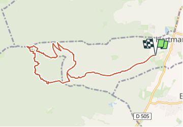
Trail On foot of 10.5 km to be discovered at Grand Est, Haut-Rhin, Hartmannswiller. This trail is proposed by berni68.

Description

Départ depuis le stand de tir - possibilités le We de boire un coup à la cantine Zeller

Elevation profile

Positioning

Country:
France
Region :
Grand Est
Department/Province :
Haut-Rhin
Municipality :
Hartmannswiller
Location:
Unknown
Start:(UTM)
365676 ; 5302185 (32T) N.

Trails nearby

Trail Walking Soultz-Haut-Rhin - Hartmannswillerkopf - Circuit découverte - Photo
Walking
VacheKiri67

Walking

Easy
(1)
Soultz-Haut-Rhin, Grand Est, Haut-Rhin, France
3.6 km | 5.2 km-effort
1h 46min
Yes
Trail Walking Soultz-Haut-Rhin - Hartmannswillerkopf - Circuit anneau bleu - Photo
Walking
VacheKiri67

Walking

Medium
(1)
Soultz-Haut-Rhin, Grand Est, Haut-Rhin, France
3.7 km | 5.9 km-effort
1h 37min
Yes
Trail Mountain bike Guebwiller - P4  Circuits du Florival 2021   - Photo
Mountain bike
duchaine.nicolas

Mountain bike

Medium
(1)
Guebwiller, Grand Est, Haut-Rhin, France
40 km | 53 km-effort
4h 31min
No
Trail Trail Wattwiller - The History Ultra - stage 1 - Photo
Trail
Olivier Houette

Trail

Very easy
(1)
Wattwiller, Grand Est, Haut-Rhin, France
28 km | 48 km-effort
Unknown
No
Trail Walking Uffholtz - Molkenrain 1 - Photo
Walking
regisbodilis

Walking

Difficult
(1)
Uffholtz, Grand Est, Haut-Rhin, France
15.4 km | 26 km-effort
4h 0min
Yes
Trail Walking Steinbach - Cascade de Erzenbach - Photo
Walking
dudu42

Walking

Medium
Steinbach, Grand Est, Haut-Rhin, France
6 km | 8.8 km-effort
1h 32min
Yes
Trail Walking Jungholtz - Rando Retrouvailles...01/03/2024.par Jean Marc - Photo
Walking
boubou68

Walking

Very difficult
Jungholtz, Grand Est, Haut-Rhin, France
11.3 km | 19.2 km-effort
1h 35min
Yes
Trail Walking Steinbach - Rando CLAS du 02/11/2023 - Photo
Walking
boubou68

Walking

Very difficult
Steinbach, Grand Est, Haut-Rhin, France
17.7 km | 27 km-effort
4h 35min
Yes
Trail Walking Steinbach - Rando Marcheurs du 03/07/2023 par ALAIN - Photo
Walking
boubou68

Walking

Very difficult
Steinbach, Grand Est, Haut-Rhin, France
20 km | 34 km-effort
5h 1min
Yes


Close
My subscriptions