![](/images/other/stat-length.png)
![Trail Walking Moutiers-au-Perche - 2023-05-20_10h18m41_Moutiers-au-Perche Rando de Samedi - Photo](https://media.geolcdn.com/t/1900/400/dd304cf5-1fa7-4625-9960-289d50411375.jpg&format=pjpeg&maxdim=2)
2023-05-20_10h18m41_Moutiers-au-Perche Rando de Samedi
ODDAD78
User
![Length](/images/other/stat-length.png)
![Max alt](https://static1.geolcdn.com/siteimages/upload/files/1508320355ic_sort_altitude_max_24dp.png)
![Uphill gradient](https://static1.geolcdn.com/siteimages/upload/files/1508320355ic_sort_den_pos_24dp.png)
![Km-Effort](/images/other/stat-length.png)
![Min alt](https://static1.geolcdn.com/siteimages/upload/files/1508320355ic_sort_altitude_min_24dp.png)
![Downhill gradient](https://static1.geolcdn.com/siteimages/upload/files/1508320355ic_sort_den_neg_24dp.png)
![Boucle](https://static1.geolcdn.com/siteimages/upload/files/16400158638029165_repeat_loop_refresh_sync_direction_icon.png)
![Walking](https://static1.geolcdn.com/sitytour/trail-icons/101.png)
1h59
Difficulty : Medium
![Scan this QR Code to open this trail in the SityTrail application](https://capi.geolives.com/qq0zvz2zws4bq2lad0pu/sitytour/trails/3666282/qr.png?size=200)
FREE GPS app for hiking
About
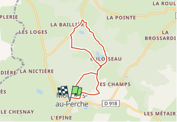
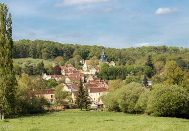
Trail Walking of 6.6 km to be discovered at Normandy, Orne, Moutiers-au-Perche. This trail is proposed by ODDAD78.
Description
Une rando comme on l'aime à Moutiers-au-Perche - Culoiseau, 6,6 km avec quelques beaux dénivelés dans un cadre toujours aussi enchanteur et quelques belles rencontres avec les membres de Perch'orizon, au milieu de fleurs sauvages, de bergeronnettes et d'arbres séculaires.
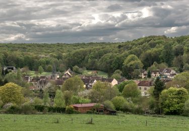
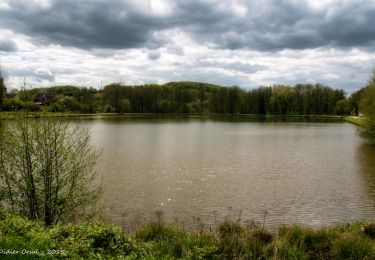
On comprend pourquoi Laumer, avant qu'il ne fût sanctifié, venant de Chartres en ermite, avait posé son sac ici vers 550 pour fonder la première abbaye bénédictine percheronne.
Positioning
Comments
Trails nearby
![Trail Walking La Madeleine-Bouvet - Les belles vues de Saint-Laumer et de la Madeleine Variante 10 Km - Photo](https://media.geolcdn.com/t/375/260/87362449-0ee3-40df-8df0-c17fd7220994.jpg&format=jpg&maxdim=2)
![Walking Walking](https://static1.geolcdn.com/sitytour/trail-icons/101.png)
Walking
![](/images/other/stat-length.png)
![](https://static1.geolcdn.com/siteimages/upload/files/16400158638029165_repeat_loop_refresh_sync_direction_icon.png)
![Trail Walking La Madeleine-Bouvet - Les belles vues de Saint-Laumer et de la Madeleine 11 Km - Photo](https://media.geolcdn.com/t/375/260/3ee85883-b7ae-45a3-90c4-8bb6a4479600.jpg&format=jpg&maxdim=2)
![Walking Walking](https://static1.geolcdn.com/sitytour/trail-icons/101.png)
Walking
![](/images/other/stat-length.png)
![](https://static1.geolcdn.com/siteimages/upload/files/16400158638029165_repeat_loop_refresh_sync_direction_icon.png)
![Trail On foot Moutiers-au-Perche - Perche authentique - Photo](https://media.geolcdn.com/t/375/260/1c5fa599-8a3f-4902-99d5-149fc7bd1ba4.jpeg&format=jpg&maxdim=2)
![On foot On foot](https://static1.geolcdn.com/sitytour/trail-icons/100.png)
On foot
![](/images/other/stat-length.png)
![](https://static1.geolcdn.com/siteimages/upload/files/16400158638029165_repeat_loop_refresh_sync_direction_icon.png)
![Trail Walking Le Mage - Le Mage - Longny-au-Perche (Longny les Villages) 11 km - Photo](https://media.geolcdn.com/t/375/260/7da85c06-6bc5-432c-afb8-5444ae0d01ad.jpg&format=jpg&maxdim=2)
![Walking Walking](https://static1.geolcdn.com/sitytour/trail-icons/101.png)
Walking
![](/images/other/stat-length.png)
![](https://static1.geolcdn.com/siteimages/upload/files/16400158638029165_repeat_loop_refresh_sync_direction_icon.png)
![Trail Walking Le Mage - Le Mage - Moutiers-au-Perche 9,2 km - Photo](https://media.geolcdn.com/t/375/260/2d6a74b1-d9ee-4f0d-9acb-9c00ceb2d8ab.jpg&format=jpg&maxdim=2)
![Walking Walking](https://static1.geolcdn.com/sitytour/trail-icons/101.png)
Walking
![](/images/other/stat-length.png)
![](https://static1.geolcdn.com/siteimages/upload/files/16400158638029165_repeat_loop_refresh_sync_direction_icon.png)
![Trail Walking La Madeleine-Bouvet - Bretoncelles - La Madeleine-Bouvet 5,3 km - Photo](https://media.geolcdn.com/t/375/260/573e294c-51f9-41fe-8907-e8f30e9f4bad.jpg&format=jpg&maxdim=2)
![Walking Walking](https://static1.geolcdn.com/sitytour/trail-icons/101.png)
Walking
![](/images/other/stat-length.png)
![](https://static1.geolcdn.com/siteimages/upload/files/16400158638029165_repeat_loop_refresh_sync_direction_icon.png)
![Trail Walking Bretoncelles - SityTrail - Les Douves du Grand Cumont Bretoncelles V2 15 Km - Photo](https://media.geolcdn.com/t/375/260/d3f7aac7-ac8c-46dc-96d3-852253cb1421.jpg&format=jpg&maxdim=2)
![Walking Walking](https://static1.geolcdn.com/sitytour/trail-icons/101.png)
Walking
![](/images/other/stat-length.png)
![](https://static1.geolcdn.com/siteimages/upload/files/16400158638029165_repeat_loop_refresh_sync_direction_icon.png)
![Trail Walking Bretoncelles - SityTrail - Le Petit Houx du Parc - Bretoncelles 5,1 Km - Photo](https://media.geolcdn.com/t/375/260/7bdb7e04-5754-4fe7-8144-30a332f42ad5.jpg&format=jpg&maxdim=2)
![Walking Walking](https://static1.geolcdn.com/sitytour/trail-icons/101.png)
Walking
![](/images/other/stat-length.png)
![](https://static1.geolcdn.com/siteimages/upload/files/16400158638029165_repeat_loop_refresh_sync_direction_icon.png)
![Trail Walking Bretoncelles - SityTrail - La boucle des Trois Moulins Bretoncelles 27,0 Km - Photo](https://media.geolcdn.com/t/375/260/5529bff9-ebf0-4b36-a1dd-763157d3177d.jpg&format=jpg&maxdim=2)
![Walking Walking](https://static1.geolcdn.com/sitytour/trail-icons/101.png)
Walking
![](/images/other/stat-length.png)
![](https://static1.geolcdn.com/siteimages/upload/files/16400158638029165_repeat_loop_refresh_sync_direction_icon.png)