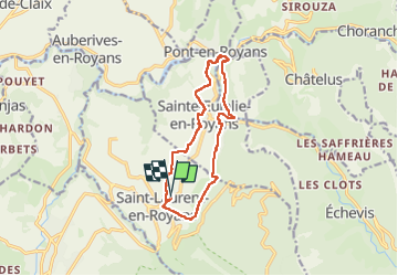
![](/images/other/stat-length.png)
![Trail Nordic walking Saint-Laurent-en-Royans - Circuit entre Saint-Laurent-en-Royans et Pont-en-Royans - Photo](https://media.geolcdn.com/t/1900/400/e35cab6e-ed35-4b24-b3a9-4e25ca3d2169.jpg&format=pjpeg&maxdim=2)
Circuit entre Saint-Laurent-en-Royans et Pont-en-Royans
Emelle
User
![Length](/images/other/stat-length.png)
![Max alt](https://static1.geolcdn.com/siteimages/upload/files/1508320355ic_sort_altitude_max_24dp.png)
![Uphill gradient](https://static1.geolcdn.com/siteimages/upload/files/1508320355ic_sort_den_pos_24dp.png)
![Km-Effort](/images/other/stat-length.png)
![Min alt](https://static1.geolcdn.com/siteimages/upload/files/1508320355ic_sort_altitude_min_24dp.png)
![Downhill gradient](https://static1.geolcdn.com/siteimages/upload/files/1508320355ic_sort_den_neg_24dp.png)
![Boucle](https://static1.geolcdn.com/siteimages/upload/files/16400158638029165_repeat_loop_refresh_sync_direction_icon.png)
![Nordic walking](https://static1.geolcdn.com/sitytour/trail-icons/102.png)
5h09
Difficulty : Medium
![Scan this QR Code to open this trail in the SityTrail application](https://capi.geolives.com/qq0zvz2zws4bq2lad0pu/sitytour/trails/3665607/qr.png?size=200)
FREE GPS app for hiking
About
Trail Nordic walking of 13 km to be discovered at Auvergne-Rhône-Alpes, Drôme, Saint-Laurent-en-Royans. This trail is proposed by Emelle.
Description
Attention on part d'une propriété privée, trouver un autre parking.
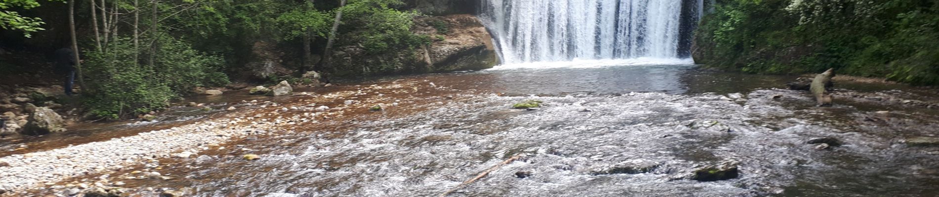
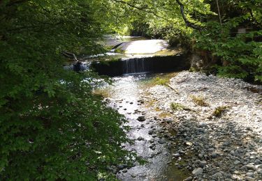
Circuit agrémenté par la traversée dans l'eau au pied de la cascade Blanche. Pique-nique à Pont-en-Royans avec la visite du Musée de l'eau.
Le temps tient compte de la marche du pique-nique et des visites.
Positioning
Comments
Trails nearby
![Trail Walking Châtelus - Boucle Pas de l'Allier - Pas des Voutes - Photo](https://media.geolcdn.com/t/375/260/ext.jpg?maxdim=2&url=https%3A%2F%2Fservices.sitytrail.com%2FGeolivesWS%2FDownloadMedia.ashx%3FTrailID%3D105085%26Media%3D8675_1.jpg)
![Walking Walking](https://static1.geolcdn.com/sitytour/trail-icons/101.png)
Walking
![](/images/other/stat-length.png)
![](https://static1.geolcdn.com/siteimages/upload/files/16400158638029165_repeat_loop_refresh_sync_direction_icon.png)
![Trail Walking Saint-Laurent-en-Royans - 26 rocher des mines ARP - Photo](https://media.geolcdn.com/t/375/260/bd4f581f-b362-467f-a5ca-afa55317a017.jpg&format=jpg&maxdim=2)
![Walking Walking](https://static1.geolcdn.com/sitytour/trail-icons/101.png)
Walking
![](/images/other/stat-length.png)
![](https://static1.geolcdn.com/siteimages/upload/files/16400158638029165_repeat_loop_refresh_sync_direction_icon.png)
![Trail Walking Sainte-Eulalie-en-Royans - 26 ste eulalie - Photo](https://media.geolcdn.com/t/375/260/cc17d7c1-039b-4811-aa20-433bfbe37107.jpg&format=jpg&maxdim=2)
![Walking Walking](https://static1.geolcdn.com/sitytour/trail-icons/101.png)
Walking
![](/images/other/stat-length.png)
![](https://static1.geolcdn.com/siteimages/upload/files/16400158638029165_repeat_loop_refresh_sync_direction_icon.png)
![Trail Walking Châtelus - 38 pabro charmatte - Photo](https://media.geolcdn.com/t/375/260/983fca8d-ac95-4180-878f-eb8932bd4279.jpg&format=jpg&maxdim=2)
![Walking Walking](https://static1.geolcdn.com/sitytour/trail-icons/101.png)
Walking
![](/images/other/stat-length.png)
![](https://static1.geolcdn.com/siteimages/upload/files/16400158638029165_repeat_loop_refresh_sync_direction_icon.png)
![Trail Walking Pont-en-Royans - 38 pont en Royans choranche presles - Photo](https://media.geolcdn.com/t/375/260/55a7031b-27da-4fe2-88f7-a5894b7e1ffc.jpg&format=jpg&maxdim=2)
![Walking Walking](https://static1.geolcdn.com/sitytour/trail-icons/101.png)
Walking
![](/images/other/stat-length.png)
![](https://static1.geolcdn.com/siteimages/upload/files/16400158638029165_repeat_loop_refresh_sync_direction_icon.png)
![Trail Walking Pont-en-Royans - 38 pont en Royans st andre - Photo](https://media.geolcdn.com/t/375/260/9999e3ad-9f99-41dc-bf89-768d521527c3.jpg&format=jpg&maxdim=2)
![Walking Walking](https://static1.geolcdn.com/sitytour/trail-icons/101.png)
Walking
![](/images/other/stat-length.png)
![](https://static1.geolcdn.com/siteimages/upload/files/16400158638029165_repeat_loop_refresh_sync_direction_icon.png)
![Trail Walking Oriol-en-Royans - 26 pas de l écho - Photo](https://media.geolcdn.com/t/375/260/ac202026-42b8-42ae-9ed4-0d1c52688ae8.jpg&format=jpg&maxdim=2)
![Walking Walking](https://static1.geolcdn.com/sitytour/trail-icons/101.png)
Walking
![](/images/other/stat-length.png)
![](https://static1.geolcdn.com/siteimages/upload/files/16400158638029165_repeat_loop_refresh_sync_direction_icon.png)
![Trail Walking Pont-en-Royans - 38 pont en Royans serre cocu - Photo](https://media.geolcdn.com/t/375/260/72853ffa-a2a8-4453-a880-6a63c61d611f.jpg&format=jpg&maxdim=2)
![Walking Walking](https://static1.geolcdn.com/sitytour/trail-icons/101.png)
Walking
![](/images/other/stat-length.png)
![](https://static1.geolcdn.com/siteimages/upload/files/16400158638029165_repeat_loop_refresh_sync_direction_icon.png)
![Trail Walking Châtelus - la grande cournouse - Photo](https://media.geolcdn.com/t/375/260/81ce0c57-e303-433f-a090-0d0401f39630.jpg&format=jpg&maxdim=2)
![Walking Walking](https://static1.geolcdn.com/sitytour/trail-icons/101.png)
Walking
![](/images/other/stat-length.png)
![](https://static1.geolcdn.com/siteimages/upload/files/16400158638029165_repeat_loop_refresh_sync_direction_icon.png)