![](/images/other/stat-length.png)
![Trail Walking Brugelette - BRUGELETTE _ Marche Fédérale _ HT _ 18/05/2023. - Photo](https://media.geolcdn.com/t/1900/400/1bb164f3-b05f-4a4f-98bf-2f2e35e949a3.jpg&format=pjpeg&maxdim=2)
BRUGELETTE _ Marche Fédérale _ HT _ 18/05/2023.
jeangulu
User
![Length](/images/other/stat-length.png)
Length
21 km
![Max alt](https://static1.geolcdn.com/siteimages/upload/files/1508320355ic_sort_altitude_max_24dp.png)
Max alt
78 m
![Uphill gradient](https://static1.geolcdn.com/siteimages/upload/files/1508320355ic_sort_den_pos_24dp.png)
Uphill gradient
184 m
![Km-Effort](/images/other/stat-length.png)
Km-Effort
24 km
![Min alt](https://static1.geolcdn.com/siteimages/upload/files/1508320355ic_sort_altitude_min_24dp.png)
Min alt
41 m
![Downhill gradient](https://static1.geolcdn.com/siteimages/upload/files/1508320355ic_sort_den_neg_24dp.png)
Downhill gradient
184 m
![Boucle](https://static1.geolcdn.com/siteimages/upload/files/16400158638029165_repeat_loop_refresh_sync_direction_icon.png)
Boucle
Yes
Creation date :
2023-05-18 08:30:59.369
Updated on :
2023-05-18 13:33:57.979
![Walking](https://static1.geolcdn.com/sitytour/trail-icons/101.png)
5h00
Difficulty : Medium
![Scan this QR Code to open this trail in the SityTrail application](https://capi.geolives.com/qq0zvz2zws4bq2lad0pu/sitytour/trails/3664132/qr.png?size=200)
FREE GPS app for hiking
About
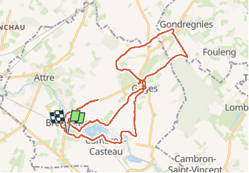
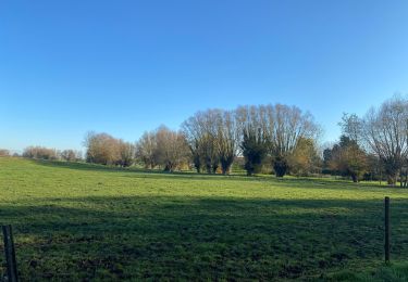
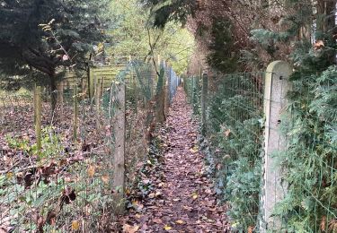
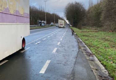
Trail Walking of 21 km to be discovered at Wallonia, Hainaut, Brugelette. This trail is proposed by jeangulu.
Description
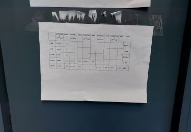
Point de départ : Salle Omnisports _ Avenue G Petit ( Parc Communal ) _ 7940 - BRUGELETTE.
Organisateur : HT 001 _LES SUCRIERS DE BRUGELETTE.
4ème Marche des Nerviers.
Carte IGN : 38/6
Positioning
Country:
Belgium
Region :
Wallonia
Department/Province :
Hainaut
Municipality :
Brugelette
Location:
Brugelette (section)
Start:(Dec)
Start:(UTM)
560375 ; 5604892 (31U) N.
Comments
Trails nearby
![Trail On foot Ath - In the footsteps of stone carvers - Photo](https://media.geolcdn.com/t/375/260/ext.jpg?maxdim=2&url=https%3A%2F%2Fpivotmedia.tourismewallonie.be%2FANX-02-04JL-01MH%2FANX-02-04JL-01MH.jpg)
![On foot On foot](https://static1.geolcdn.com/sitytour/trail-icons/100.png)
In the footsteps of stone carvers
On foot
Easy
Ath,
Wallonia,
Hainaut,
Belgium
![](/images/other/stat-length.png)
3.3 km | 3.6 km-effort
49min
![](https://static1.geolcdn.com/siteimages/upload/files/16400158638029165_repeat_loop_refresh_sync_direction_icon.png)
Yes
![Trail On foot Silly - Walk around castles and Bois de la Provision wood - Photo](https://media.geolcdn.com/t/375/260/ext.jpg?maxdim=2&url=https%3A%2F%2Fpivotmedia.tourismewallonie.be%2FANX-02-04OE-001F%2FANX-02-04OE-001F.JPG)
![On foot On foot](https://static1.geolcdn.com/sitytour/trail-icons/100.png)
Walk around castles and Bois de la Provision wood
On foot
Easy
Silly,
Wallonia,
Hainaut,
Belgium
![](/images/other/stat-length.png)
10.2 km | 11.8 km-effort
2h 40min
![](https://static1.geolcdn.com/siteimages/upload/files/16400158638029165_repeat_loop_refresh_sync_direction_icon.png)
Yes
![Trail Walking Silly - w-belgie-gondregnies - Photo](https://media.geolcdn.com/t/375/260/ext.jpg?maxdim=2&url=https%3A%2F%2Fstatic1.geolcdn.com%2Fsiteimages%2Fupload%2Ffiles%2F1553511878bg_sport_marche.png)
![Walking Walking](https://static1.geolcdn.com/sitytour/trail-icons/101.png)
w-belgie-gondregnies
Walking
Very easy
(1)
Silly,
Wallonia,
Hainaut,
Belgium
![](/images/other/stat-length.png)
10.1 km | 11.6 km-effort
Unknown
![](https://static1.geolcdn.com/siteimages/upload/files/16400158638029165_repeat_loop_refresh_sync_direction_icon.png)
Yes
![Trail Walking Brugelette - Brugelette 20 km - Photo](https://media.geolcdn.com/t/375/260/f2639476-db34-4d61-bd99-d69ab287969d.jpg&format=jpg&maxdim=2)
![Walking Walking](https://static1.geolcdn.com/sitytour/trail-icons/101.png)
Brugelette 20 km
Walking
Easy
Brugelette,
Wallonia,
Hainaut,
Belgium
![](/images/other/stat-length.png)
20 km | 23 km-effort
4h 46min
![](https://static1.geolcdn.com/siteimages/upload/files/16400158638029165_repeat_loop_refresh_sync_direction_icon.png)
Yes
![Trail Walking Silly - Gondregnies - bois de la Provision - Fouleng - Photo](https://media.geolcdn.com/t/375/260/4be76424-6eca-4a44-9151-f1b4a66b5b37.jpg&format=jpg&maxdim=2)
![Walking Walking](https://static1.geolcdn.com/sitytour/trail-icons/101.png)
Gondregnies - bois de la Provision - Fouleng
Walking
Very easy
Silly,
Wallonia,
Hainaut,
Belgium
![](/images/other/stat-length.png)
16.2 km | 18.2 km-effort
2h 10min
![](https://static1.geolcdn.com/siteimages/upload/files/16400158638029165_repeat_loop_refresh_sync_direction_icon.png)
No
![Trail Running Brugelette - Brugelette Bauffe Lens Cambron Vincent / Casteau Brugelette - Photo](https://media.geolcdn.com/t/375/260/b55b18ee-5b53-4ffc-b191-836f08df109e.jpg&format=jpg&maxdim=2)
![Running Running](https://static1.geolcdn.com/sitytour/trail-icons/103.png)
Brugelette Bauffe Lens Cambron Vincent / Casteau Brugelette
Running
Very easy
Brugelette,
Wallonia,
Hainaut,
Belgium
![](/images/other/stat-length.png)
23 km | 25 km-effort
3h 12min
![](https://static1.geolcdn.com/siteimages/upload/files/16400158638029165_repeat_loop_refresh_sync_direction_icon.png)
Yes
![Trail Walking Brugelette - Brugelette - Fauleng - Gondregnies - Mevergnies - Photo](https://media.geolcdn.com/t/375/260/6bd30030-c930-495c-b719-b8101daf8ecd.jpg&format=jpg&maxdim=2)
![Walking Walking](https://static1.geolcdn.com/sitytour/trail-icons/101.png)
Brugelette - Fauleng - Gondregnies - Mevergnies
Walking
Very easy
Brugelette,
Wallonia,
Hainaut,
Belgium
![](/images/other/stat-length.png)
15 km | 16.4 km-effort
2h 20min
![](https://static1.geolcdn.com/siteimages/upload/files/16400158638029165_repeat_loop_refresh_sync_direction_icon.png)
Yes
![Trail Running Ath - Petit décrassage sympa - Photo](https://media.geolcdn.com/t/375/260/eb65d489-5b3a-4da6-8415-b81d46479932.jpg&format=jpg&maxdim=2)
![Running Running](https://static1.geolcdn.com/sitytour/trail-icons/103.png)
Petit décrassage sympa
Running
Easy
Ath,
Wallonia,
Hainaut,
Belgium
![](/images/other/stat-length.png)
8 km | 8.6 km-effort
1h 33min
![](https://static1.geolcdn.com/siteimages/upload/files/16400158638029165_repeat_loop_refresh_sync_direction_icon.png)
No
![Trail Walking Brugelette - BRUGELETTE _ Marche Fédérale _ HT _12/08/2023 - Photo](https://media.geolcdn.com/t/375/260/cc781d37-bb57-4b37-89c0-df83e01a2d12.jpg&format=jpg&maxdim=2)
![Walking Walking](https://static1.geolcdn.com/sitytour/trail-icons/101.png)
BRUGELETTE _ Marche Fédérale _ HT _12/08/2023
Walking
Medium
Brugelette,
Wallonia,
Hainaut,
Belgium
![](/images/other/stat-length.png)
21 km | 23 km-effort
4h 46min
![](https://static1.geolcdn.com/siteimages/upload/files/16400158638029165_repeat_loop_refresh_sync_direction_icon.png)
Yes