![](/images/other/stat-length.png)
![Trail Walking Préfailles - Boucle en pointe de Saint Gildas - Photo](https://media.geolcdn.com/t/1900/400/ext.pjpeg?maxdim=2&url=https%3A%2F%2Fmedia.geolcdn.com%2Ff%2F38fd5f4a-0ffa-466a-8e18-2f488e284f1b.jpg)
Boucle en pointe de Saint Gildas
choubaka77
User
![Length](/images/other/stat-length.png)
Length
16 km
![Max alt](https://static1.geolcdn.com/siteimages/upload/files/1508320355ic_sort_altitude_max_24dp.png)
Max alt
36 m
![Uphill gradient](https://static1.geolcdn.com/siteimages/upload/files/1508320355ic_sort_den_pos_24dp.png)
Uphill gradient
98 m
![Km-Effort](/images/other/stat-length.png)
Km-Effort
17.3 km
![Min alt](https://static1.geolcdn.com/siteimages/upload/files/1508320355ic_sort_altitude_min_24dp.png)
Min alt
-1 m
![Downhill gradient](https://static1.geolcdn.com/siteimages/upload/files/1508320355ic_sort_den_neg_24dp.png)
Downhill gradient
98 m
![Boucle](https://static1.geolcdn.com/siteimages/upload/files/16400158638029165_repeat_loop_refresh_sync_direction_icon.png)
Boucle
Yes
Creation date :
2023-05-13 08:35:35.0
Updated on :
2023-05-13 14:40:51.062
![Walking](https://static1.geolcdn.com/sitytour/trail-icons/101.png)
4h10
Difficulty : Very easy
![Scan this QR Code to open this trail in the SityTrail application](https://capi.geolives.com/qq0zvz2zws4bq2lad0pu/sitytour/trails/3657930/qr.png?size=200)
FREE GPS app for hiking
About
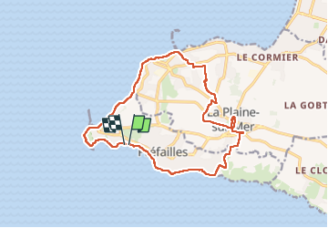
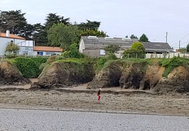
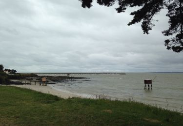
Trail Walking of 16 km to be discovered at Pays de la Loire, Loire-Atlantique, Préfailles. This trail is proposed by choubaka77.
Description
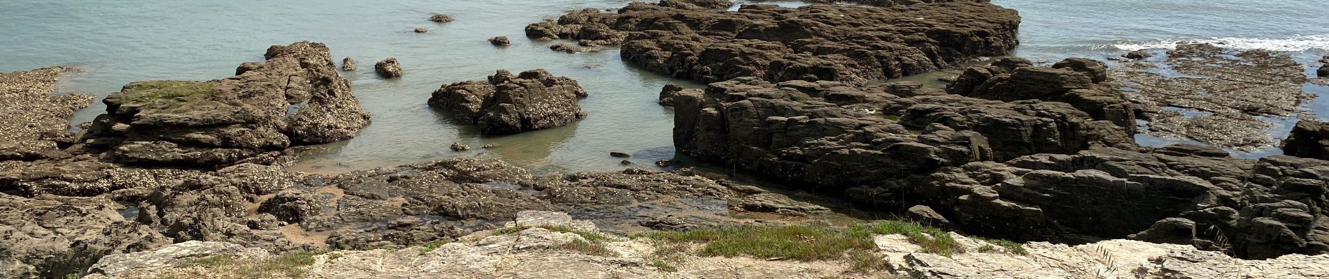
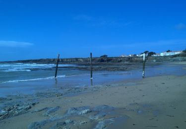
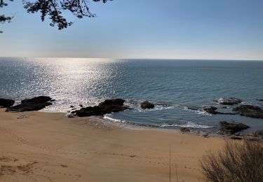
Très belle balade qui fait découvrir toutes les facettes de la partie sud de l’estuaire de la Loire au niveau de la pointe Saint Gildas.
Positioning
Country:
France
Region :
Pays de la Loire
Department/Province :
Loire-Atlantique
Municipality :
Préfailles
Location:
Unknown
Start:(Dec)
Start:(UTM)
558324 ; 5220078 (30T) N.
Comments
Trails nearby
![Trail On foot Préfailles - Pointe Saint-Gildas - Photo](https://media.geolcdn.com/t/375/260/ext.jpg?maxdim=2&url=https%3A%2F%2Fmedia.geolcdn.com%2Ff%2Fd0c5c2f6-34d6-4bc5-b58c-e9e0785cf5f0.jpeg)
![On foot On foot](https://static1.geolcdn.com/sitytour/trail-icons/100.png)
Pointe Saint-Gildas
On foot
Easy
Préfailles,
Pays de la Loire,
Loire-Atlantique,
France
![](/images/other/stat-length.png)
7.3 km | 8 km-effort
1h 49min
![](https://static1.geolcdn.com/siteimages/upload/files/16400158638029165_repeat_loop_refresh_sync_direction_icon.png)
Yes
![Trail Walking La Plaine-sur-Mer - La plaine sur Mer - Pornic - Photo](https://media.geolcdn.com/t/375/260/ext.jpg?maxdim=2&url=https%3A%2F%2Fmedia.geolcdn.com%2Ff%2F3e6d4e01-0318-4670-946f-5a06ee1210d0.jpg)
![Walking Walking](https://static1.geolcdn.com/sitytour/trail-icons/101.png)
La plaine sur Mer - Pornic
Walking
Medium
La Plaine-sur-Mer,
Pays de la Loire,
Loire-Atlantique,
France
![](/images/other/stat-length.png)
20 km | 22 km-effort
3h 59min
![](https://static1.geolcdn.com/siteimages/upload/files/16400158638029165_repeat_loop_refresh_sync_direction_icon.png)
No
![Trail Walking Préfailles - Pointe de St Gildas - Photo](https://media.geolcdn.com/t/375/260/ext.jpg?maxdim=2&url=https%3A%2F%2Fmedia.geolcdn.com%2Ff%2F676edf4a-b6e7-4a74-8e49-d68639926018.jpg)
![Walking Walking](https://static1.geolcdn.com/sitytour/trail-icons/101.png)
Pointe de St Gildas
Walking
Very easy
Préfailles,
Pays de la Loire,
Loire-Atlantique,
France
![](/images/other/stat-length.png)
9.5 km | 10.5 km-effort
3h 7min
![](https://static1.geolcdn.com/siteimages/upload/files/16400158638029165_repeat_loop_refresh_sync_direction_icon.png)
Yes
![Trail Walking La Plaine-sur-Mer - pornichet - Photo](https://media.geolcdn.com/t/375/260/ext.jpg?maxdim=2&url=https%3A%2F%2Fmedia.geolcdn.com%2Ff%2Fa6e703b2-84bf-42ae-ac9b-cf1d1769c179.jpg)
![Walking Walking](https://static1.geolcdn.com/sitytour/trail-icons/101.png)
pornichet
Walking
Very easy
La Plaine-sur-Mer,
Pays de la Loire,
Loire-Atlantique,
France
![](/images/other/stat-length.png)
58 km | 63 km-effort
4h 26min
![](https://static1.geolcdn.com/siteimages/upload/files/16400158638029165_repeat_loop_refresh_sync_direction_icon.png)
No
![Trail Other activity La Plaine-sur-Mer - côte des moutons - Photo](https://media.geolcdn.com/t/375/260/ext.jpg?maxdim=2&url=https%3A%2F%2Fservices.sitytrail.com%2FGeolivesWS%2FDownloadMedia.ashx%3FTrailID%3D558942%26Media%3D20160425170255.jpg)
![Other activity Other activity](https://static1.geolcdn.com/sitytour/trail-icons/900.png)
côte des moutons
Other activity
Easy
La Plaine-sur-Mer,
Pays de la Loire,
Loire-Atlantique,
France
![](/images/other/stat-length.png)
13 km | 14 km-effort
3h 32min
![](https://static1.geolcdn.com/siteimages/upload/files/16400158638029165_repeat_loop_refresh_sync_direction_icon.png)
Yes
![Trail Mountain bike La Plaine-sur-Mer - La Plaine Eric 3 - Photo](https://media.geolcdn.com/t/375/260/ext.jpg?maxdim=2&url=https%3A%2F%2Fstatic1.geolcdn.com%2Fsiteimages%2Fupload%2Ffiles%2F1524743154velo.jpg)
![Mountain bike Mountain bike](https://static1.geolcdn.com/sitytour/trail-icons/202.png)
La Plaine Eric 3
Mountain bike
Medium
La Plaine-sur-Mer,
Pays de la Loire,
Loire-Atlantique,
France
![](/images/other/stat-length.png)
31 km | 35 km-effort
2h 7min
![](https://static1.geolcdn.com/siteimages/upload/files/16400158638029165_repeat_loop_refresh_sync_direction_icon.png)
Yes
![Trail Walking Saint-Michel-Chef-Chef - 2023-06-03 st Michel chef chef circuit littoral et moulins - Photo](https://media.geolcdn.com/t/375/260/ext.jpg?maxdim=2&url=https%3A%2F%2Fmedia.geolcdn.com%2Ff%2Fb5dec514-b985-4f83-b732-11df6eab5f8a.jpg)
![Walking Walking](https://static1.geolcdn.com/sitytour/trail-icons/101.png)
2023-06-03 st Michel chef chef circuit littoral et moulins
Walking
Difficult
Saint-Michel-Chef-Chef,
Pays de la Loire,
Loire-Atlantique,
France
![](/images/other/stat-length.png)
15.7 km | 17.2 km-effort
3h 20min
![](https://static1.geolcdn.com/siteimages/upload/files/16400158638029165_repeat_loop_refresh_sync_direction_icon.png)
No
![Trail Mountain bike La Plaine-sur-Mer - Claude La Plaine Prefailles - Photo](https://media.geolcdn.com/t/375/260/ext.jpg?maxdim=2&url=https%3A%2F%2Fstatic1.geolcdn.com%2Fsiteimages%2Fupload%2Ffiles%2F1524743154velo.jpg)
![Mountain bike Mountain bike](https://static1.geolcdn.com/sitytour/trail-icons/202.png)
Claude La Plaine Prefailles
Mountain bike
Easy
La Plaine-sur-Mer,
Pays de la Loire,
Loire-Atlantique,
France
![](/images/other/stat-length.png)
34 km | 37 km-effort
2h 28min
![](https://static1.geolcdn.com/siteimages/upload/files/16400158638029165_repeat_loop_refresh_sync_direction_icon.png)
No
![Trail Electric bike Préfailles - prefailles la barre de Monts - Photo](https://media.geolcdn.com/t/375/260/ext.jpg?maxdim=2&url=https%3A%2F%2Fmedia.geolcdn.com%2Ff%2Fe71c9c61-e204-4b69-8995-0cde4b7af8e8.jpg)
![Electric bike Electric bike](https://static1.geolcdn.com/sitytour/trail-icons/205.png)
prefailles la barre de Monts
Electric bike
Very easy
Préfailles,
Pays de la Loire,
Loire-Atlantique,
France
![](/images/other/stat-length.png)
69 km | 0 m-effort
6h 1min
![](https://static1.geolcdn.com/siteimages/upload/files/16400158638029165_repeat_loop_refresh_sync_direction_icon.png)
No