![Trail Walking Unknown - Treck du Sham - Photo](https://media.geolcdn.com/t/1900/400/ext.pjpeg?maxdim=2&url=https%3A%2F%2Fstatic1.geolcdn.com%2Fsiteimages%2Fupload%2Ffiles%2F1553511878bg_sport_marche.png)
Treck du Sham
ach31
User
![Length](/images/other/stat-length.png)
Length
34 km
![Max alt](https://static1.geolcdn.com/siteimages/upload/files/1508320355ic_sort_altitude_max_24dp.png)
Max alt
3876 m
![Uphill gradient](https://static1.geolcdn.com/siteimages/upload/files/1508320355ic_sort_den_pos_24dp.png)
Uphill gradient
1396 m
![Km-Effort](/images/other/stat-length.png)
Km-Effort
55 km
![Min alt](https://static1.geolcdn.com/siteimages/upload/files/1508320355ic_sort_altitude_min_24dp.png)
Min alt
3000 m
![Downhill gradient](https://static1.geolcdn.com/siteimages/upload/files/1508320355ic_sort_den_neg_24dp.png)
Downhill gradient
1952 m
![Boucle](https://static1.geolcdn.com/siteimages/upload/files/16400158638029165_repeat_loop_refresh_sync_direction_icon.png)
Boucle
No
Creation date :
2014-12-10 00:00:00.0
Updated on :
2014-12-10 00:00:00.0
![Walking](https://static1.geolcdn.com/sitytour/trail-icons/101.png)
10h49
Difficulty : Medium
![Scan this QR Code to open this trail in the SityTrail application](https://capi.geolives.com/qq0zvz2zws4bq2lad0pu/sitytour/trails/365674/qr.png?size=200)
FREE GPS app for hiking
About
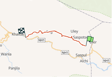
Trail Walking of 34 km to be discovered at Ladakh, Khaltsi. This trail is proposed by ach31.
Positioning
Country:
India
Region :
Ladakh
Department/Province :
Khaltsi
Municipality :
Unknown
Location:
Unknown
Start:(Dec)
Start:(UTM)
700853 ; 3795197 (43S) N.
Comments
Trails nearby