![](/images/other/stat-length.png)
![Trail Mountain bike Crans-Montana - Tour de Courtavey - Photo](https://media.geolcdn.com/t/1900/400/ext.pjpeg?maxdim=2&url=https%3A%2F%2Fservices.sitytrail.com%2FGeolivesWS%2FDownloadMedia.ashx%3FTrailID%3D36540%26Media%3Dimage0.jpg)
Tour de Courtavey
Maison du Tourisme Crans-Montana
Randonnées de la Maison du tourisme de Crans-Montana GUIDE+
![Length](/images/other/stat-length.png)
![Max alt](https://static1.geolcdn.com/siteimages/upload/files/1508320355ic_sort_altitude_max_24dp.png)
![Uphill gradient](https://static1.geolcdn.com/siteimages/upload/files/1508320355ic_sort_den_pos_24dp.png)
![Km-Effort](/images/other/stat-length.png)
![Min alt](https://static1.geolcdn.com/siteimages/upload/files/1508320355ic_sort_altitude_min_24dp.png)
![Downhill gradient](https://static1.geolcdn.com/siteimages/upload/files/1508320355ic_sort_den_neg_24dp.png)
![Boucle](https://static1.geolcdn.com/siteimages/upload/files/16400158638029165_repeat_loop_refresh_sync_direction_icon.png)
![Mountain bike](https://static1.geolcdn.com/sitytour/trail-icons/202.png)
2h00
Difficulty : Unknown
![Scan this QR Code to open this trail in the SityTrail application](https://capi.geolives.com/qq0zvz2zws4bq2lad0pu/sitytour/trails/36540/qr.png?size=200)
FREE GPS app for hiking
About
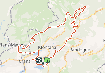
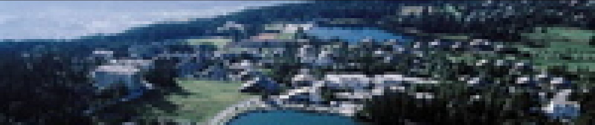
Trail Mountain bike of 12.2 km to be discovered at Valais/Wallis, Sierre, Crans-Montana. This trail is proposed by Maison du Tourisme Crans-Montana.
Description
Es ist eine Rundstrecke, die die sportlicheren unter Ihnen vom Moubra-See nach Crans-Montana führt. Nachdem Sie neben dem Grenon-See vorbeigefahren sind, geht es hoch auf die Alp, in Richtung Signal über Arnouvaz, wo man im Winter Skifahren kann. Von diesem Punkt her ist es möglich, einen kleinen Abstecher bis zur Alp von Corbyre zu machen, wo Sie einheimische Käsesorten probieren können.
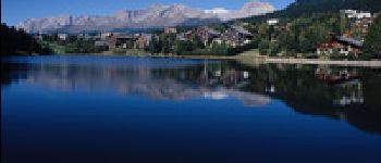
Nachdem Sie bis Courtavey gefahren und durch die Zone der Maiensässe gefahren sind, fahren Sie bei Plumachit und Barzettes herunter zurück zum Ausgangspunkt, dort können Sie sich am Strand des Moubra-Sees erfrischen und entspannen, wo man auch gut schwimmen kann. Dort finden Sie zwei Restaurants mit gastfreundlichen Terrassen.
Ein grosser Teil der Rundfahrt findet auf geteerten Strassen und ungeteerten Wegen statt. Dabei durchqueren Sie den Ferienort, die Waldgebiete und Viehweiden. Verschiedene Orte eignen sich für kleine Pausen, zum Beispiel die Pizzeria von Arnouvaz.
Points of interest
Positioning
Comments
Trails nearby
![Trail Mountain bike Crans-Montana - Tour des villages - Photo](https://media.geolcdn.com/t/375/260/ext.jpg?maxdim=2&url=https%3A%2F%2Fservices.sitytrail.com%2FGeolivesWS%2FDownloadMedia.ashx%3FTrailID%3D36534%26Media%3Dimage5.jpg)
![Mountain bike Mountain bike](https://static1.geolcdn.com/sitytour/trail-icons/202.png)
Mountain bike
![](/images/other/stat-length.png)
![](https://static1.geolcdn.com/siteimages/upload/files/16400158638029165_repeat_loop_refresh_sync_direction_icon.png)
![Trail On foot Lens - Cran - Er de Chermignon (Ancien bisse du Ro) - Photo](https://media.geolcdn.com/t/375/260/ext.jpg?maxdim=2&url=https%3A%2F%2Fmedia.geolcdn.com%2Ff%2F84b58328-5d06-4f13-b83a-af1e8e0636db.jpeg)
![On foot On foot](https://static1.geolcdn.com/sitytour/trail-icons/100.png)
On foot
![](/images/other/stat-length.png)
![](https://static1.geolcdn.com/siteimages/upload/files/16400158638029165_repeat_loop_refresh_sync_direction_icon.png)
![Trail On foot Icogne - Pra du taillour-Pas de l'ours - Photo](https://media.geolcdn.com/t/375/260/ext.jpg?maxdim=2&url=https%3A%2F%2Fmedia.geolcdn.com%2Ff%2Fef6b797d-35a7-46b4-bdb0-32d69f63d118.jpeg)
![On foot On foot](https://static1.geolcdn.com/sitytour/trail-icons/100.png)
On foot
![](/images/other/stat-length.png)
![](https://static1.geolcdn.com/siteimages/upload/files/16400158638029165_repeat_loop_refresh_sync_direction_icon.png)
![Trail On foot Icogne - Er de Chermignon-Pra du Taillour - Photo](https://media.geolcdn.com/t/375/260/ext.jpg?maxdim=2&url=https%3A%2F%2Fmedia.geolcdn.com%2Ff%2Fd8c5cc1d-ad6e-422d-86e5-d27a18101d18.jpeg)
![On foot On foot](https://static1.geolcdn.com/sitytour/trail-icons/100.png)
On foot
![](/images/other/stat-length.png)
![](https://static1.geolcdn.com/siteimages/upload/files/16400158638029165_repeat_loop_refresh_sync_direction_icon.png)
![Trail On foot Crans-Montana - Plaine Morte-Les Violettes - Photo](https://media.geolcdn.com/t/375/260/ext.jpg?maxdim=2&url=https%3A%2F%2Fmedia.geolcdn.com%2Ff%2Fc98b81be-8263-4c89-b2bb-91e6ef097c06.jpeg)
![On foot On foot](https://static1.geolcdn.com/sitytour/trail-icons/100.png)
On foot
![](/images/other/stat-length.png)
![](https://static1.geolcdn.com/siteimages/upload/files/16400158638029165_repeat_loop_refresh_sync_direction_icon.png)
![Trail Walking Crans-Montana - Chemin du Vignoble - Itinéraire dégustation - Photo](https://media.geolcdn.com/t/375/260/ext.jpg?maxdim=2&url=https%3A%2F%2Fservices.sitytrail.com%2FGeolivesWS%2FDownloadMedia.ashx%3FTrailID%3D46260%26Media%3Dimage6.jpg)
![Walking Walking](https://static1.geolcdn.com/sitytour/trail-icons/101.png)
Walking
![](/images/other/stat-length.png)
![](https://static1.geolcdn.com/siteimages/upload/files/16400158638029165_repeat_loop_refresh_sync_direction_icon.png)
![Trail Walking Icogne - Bisse du Sillonin - Photo](https://media.geolcdn.com/t/375/260/ext.jpg?maxdim=2&url=https%3A%2F%2Fservices.sitytrail.com%2FGeolivesWS%2FDownloadMedia.ashx%3FTrailID%3D44661%26Media%3Dimage10.jpg)
![Walking Walking](https://static1.geolcdn.com/sitytour/trail-icons/101.png)
Walking
![](/images/other/stat-length.png)
![](https://static1.geolcdn.com/siteimages/upload/files/16400158638029165_repeat_loop_refresh_sync_direction_icon.png)
![Trail Mountain bike Crans-Montana - Tour Hauts de Crans - Photo](https://media.geolcdn.com/t/375/260/ext.jpg?maxdim=2&url=https%3A%2F%2Fservices.sitytrail.com%2FGeolivesWS%2FDownloadMedia.ashx%3FTrailID%3D36537%26Media%3Dimage0.jpg)
![Mountain bike Mountain bike](https://static1.geolcdn.com/sitytour/trail-icons/202.png)
Mountain bike
![](/images/other/stat-length.png)
![](https://static1.geolcdn.com/siteimages/upload/files/16400158638029165_repeat_loop_refresh_sync_direction_icon.png)
![Trail Walking Noble-Contrée - Bisse Neuf and Bisse de Varen - Photo](https://media.geolcdn.com/t/375/260/ext.jpg?maxdim=2&url=https%3A%2F%2Fservices.sitytrail.com%2FGeolivesWS%2FDownloadMedia.ashx%3FTrailID%3D36527%26Media%3Dimage14.jpg)
![Walking Walking](https://static1.geolcdn.com/sitytour/trail-icons/101.png)
Walking
![](/images/other/stat-length.png)
![](https://static1.geolcdn.com/siteimages/upload/files/16400158638029165_repeat_loop_refresh_sync_direction_icon.png)