![](/images/other/stat-length.png)
![Trail Electric bike Saint-Jeannet - boucle st Barnabé les Courmettes - Photo](https://media.geolcdn.com/t/1900/400/ext.pjpeg?maxdim=2&url=https%3A%2F%2Fstatic1.geolcdn.com%2Fsiteimages%2Fupload%2Ffiles%2F1524743154velo.jpg)
boucle st Barnabé les Courmettes
franquen
User
![Length](/images/other/stat-length.png)
Length
52 km
![Max alt](https://static1.geolcdn.com/siteimages/upload/files/1508320355ic_sort_altitude_max_24dp.png)
Max alt
974 m
![Uphill gradient](https://static1.geolcdn.com/siteimages/upload/files/1508320355ic_sort_den_pos_24dp.png)
Uphill gradient
1263 m
![Km-Effort](/images/other/stat-length.png)
Km-Effort
69 km
![Min alt](https://static1.geolcdn.com/siteimages/upload/files/1508320355ic_sort_altitude_min_24dp.png)
Min alt
215 m
![Downhill gradient](https://static1.geolcdn.com/siteimages/upload/files/1508320355ic_sort_den_neg_24dp.png)
Downhill gradient
1263 m
![Boucle](https://static1.geolcdn.com/siteimages/upload/files/16400158638029165_repeat_loop_refresh_sync_direction_icon.png)
Boucle
Yes
Creation date :
2023-05-08 07:20:01.386
Updated on :
2023-05-08 13:34:37.664
![Electric bike](https://static1.geolcdn.com/sitytour/trail-icons/205.png)
5h40
Difficulty : Medium
![Scan this QR Code to open this trail in the SityTrail application](https://capi.geolives.com/qq0zvz2zws4bq2lad0pu/sitytour/trails/3651710/qr.png?size=200)
FREE GPS app for hiking
About
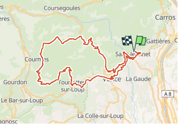
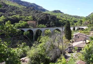
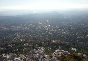
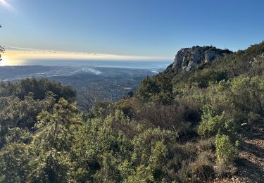
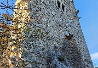
Trail Electric bike of 52 km to be discovered at Provence-Alpes-Côte d'Azur, Maritime Alps, Saint-Jeannet. This trail is proposed by franquen.
Description
Partant de St Jeannet, très beau circuit avec des paysages variés et des vues panoramiques. Il passe par le col de vence, St Barnabé, le domaine des Courmettes, Tourette sur Loup puis Vence par les petites routes.
Positioning
Country:
France
Region :
Provence-Alpes-Côte d'Azur
Department/Province :
Maritime Alps
Municipality :
Saint-Jeannet
Location:
Unknown
Start:(Dec)
Start:(UTM)
350620 ; 4845725 (32T) N.
Comments
Trails nearby
![Trail Walking Saint-Jeannet - Baou de Saint-Jeannet - Photo](https://media.geolcdn.com/t/375/260/d4c22365-bd73-4ba1-a46d-47812961244f.jpg&format=jpg&maxdim=2)
![Walking Walking](https://static1.geolcdn.com/sitytour/trail-icons/101.png)
Baou de Saint-Jeannet
Walking
Medium
(1)
Saint-Jeannet,
Provence-Alpes-Côte d'Azur,
Maritime Alps,
France
![](/images/other/stat-length.png)
7.5 km | 13.4 km-effort
3h 15min
![](https://static1.geolcdn.com/siteimages/upload/files/16400158638029165_repeat_loop_refresh_sync_direction_icon.png)
No
![Trail On foot Vence - Circuit des Blaquières - Photo](https://media.geolcdn.com/t/375/260/46014005-cf89-423b-a650-f449be44d3f6.jpeg&format=jpg&maxdim=2)
![On foot On foot](https://static1.geolcdn.com/sitytour/trail-icons/100.png)
Circuit des Blaquières
On foot
Easy
Vence,
Provence-Alpes-Côte d'Azur,
Maritime Alps,
France
![](/images/other/stat-length.png)
5.2 km | 8.6 km-effort
1h 57min
![](https://static1.geolcdn.com/siteimages/upload/files/16400158638029165_repeat_loop_refresh_sync_direction_icon.png)
Yes
![Trail On foot Gattières - Baou de la Gaude - Photo](https://media.geolcdn.com/t/375/260/ab686055-453b-4527-9610-4cf7a5679c21.jpeg&format=jpg&maxdim=2)
![On foot On foot](https://static1.geolcdn.com/sitytour/trail-icons/100.png)
Baou de la Gaude
On foot
Easy
Gattières,
Provence-Alpes-Côte d'Azur,
Maritime Alps,
France
![](/images/other/stat-length.png)
9.5 km | 17.7 km-effort
4h 1min
![](https://static1.geolcdn.com/siteimages/upload/files/16400158638029165_repeat_loop_refresh_sync_direction_icon.png)
Yes
![Trail On foot Carros - Les Balcons de Carros - Photo](https://media.geolcdn.com/t/375/260/a6a71bca-0b2f-4793-9dae-094488c13d6e.jpeg&format=jpg&maxdim=2)
![On foot On foot](https://static1.geolcdn.com/sitytour/trail-icons/100.png)
Les Balcons de Carros
On foot
Easy
Carros,
Provence-Alpes-Côte d'Azur,
Maritime Alps,
France
![](/images/other/stat-length.png)
4.9 km | 9.1 km-effort
2h 4min
![](https://static1.geolcdn.com/siteimages/upload/files/16400158638029165_repeat_loop_refresh_sync_direction_icon.png)
Yes
![Trail On foot Vence - Plan des Noves - Photo](https://media.geolcdn.com/t/375/260/5bdbad17-ece4-4950-8e82-290491f5430d.jpeg&format=jpg&maxdim=2)
![On foot On foot](https://static1.geolcdn.com/sitytour/trail-icons/100.png)
Plan des Noves
On foot
Easy
Vence,
Provence-Alpes-Côte d'Azur,
Maritime Alps,
France
![](/images/other/stat-length.png)
7.2 km | 10.3 km-effort
2h 20min
![](https://static1.geolcdn.com/siteimages/upload/files/16400158638029165_repeat_loop_refresh_sync_direction_icon.png)
Yes
![Trail On foot Saint-Jeannet - Circuit du Castellet - Photo](https://media.geolcdn.com/t/375/260/afc23e4e-bd37-42a8-b455-4fba696582ad.jpeg&format=jpg&maxdim=2)
![On foot On foot](https://static1.geolcdn.com/sitytour/trail-icons/100.png)
Circuit du Castellet
On foot
Easy
Saint-Jeannet,
Provence-Alpes-Côte d'Azur,
Maritime Alps,
France
![](/images/other/stat-length.png)
8.2 km | 14.1 km-effort
3h 12min
![](https://static1.geolcdn.com/siteimages/upload/files/16400158638029165_repeat_loop_refresh_sync_direction_icon.png)
Yes
![Trail Walking Vence - Vence le Baou des Blancs - Photo](https://media.geolcdn.com/t/375/260/ext.jpg?maxdim=2&url=https%3A%2F%2Fservices.sitytrail.com%2FGeolivesWS%2FDownloadMedia.ashx%3FTrailID%3D168755%26Media%3D20130105141841.jpeg)
![Walking Walking](https://static1.geolcdn.com/sitytour/trail-icons/101.png)
Vence le Baou des Blancs
Walking
Easy
(2)
Vence,
Provence-Alpes-Côte d'Azur,
Maritime Alps,
France
![](/images/other/stat-length.png)
7.3 km | 11.2 km-effort
2h 24min
![](https://static1.geolcdn.com/siteimages/upload/files/16400158638029165_repeat_loop_refresh_sync_direction_icon.png)
Yes
![Trail Walking Saint-Jeannet - St Jeannet : les Baous janv 2025 - Photo](https://media.geolcdn.com/t/375/260/362b31cc-013f-4b2f-a360-d53c75d51365.jpg&format=jpg&maxdim=2)
![Walking Walking](https://static1.geolcdn.com/sitytour/trail-icons/101.png)
St Jeannet : les Baous janv 2025
Walking
Difficult
Saint-Jeannet,
Provence-Alpes-Côte d'Azur,
Maritime Alps,
France
![](/images/other/stat-length.png)
17.2 km | 28 km-effort
6h 25min
![](https://static1.geolcdn.com/siteimages/upload/files/16400158638029165_repeat_loop_refresh_sync_direction_icon.png)
Yes
![Trail Walking Saint-Jeannet - Baous de la Gaude et de St Jeannet - Photo](https://media.geolcdn.com/t/375/260/3655e9c4-c4c4-495a-bc74-b57cc8e907b9.jpg&format=jpg&maxdim=2)
![Walking Walking](https://static1.geolcdn.com/sitytour/trail-icons/101.png)
Baous de la Gaude et de St Jeannet
Walking
Medium
Saint-Jeannet,
Provence-Alpes-Côte d'Azur,
Maritime Alps,
France
![](/images/other/stat-length.png)
15 km | 26 km-effort
5h 51min
![](https://static1.geolcdn.com/siteimages/upload/files/16400158638029165_repeat_loop_refresh_sync_direction_icon.png)
Yes