Trail Road bike Aubagne - L' Espigoulier 723m D+900m - Photo
© OpenStreetMap contributors
Length
Length
39 km
Max alt
Max alt
744 m
Uphill gradient
Uphill gradient
909 m
Km-Effort
Km-Effort  
51 km
Min alt
Min alt
128 m
Downhill gradient
Downhill gradient
907 m
Boucle
Boucle
Yes
Creation date :
2023-05-06 14:59:05.322
Updated on :
2023-05-21 12:16:55.698

(0 Reviews)

Road bike
Road bike
3h05
Difficulty : Very difficult

Scan this QR Code to open this trail in the SityTrail application

FREE GPS app for hiking

Logo SityTrail SityTrail

IGN / Geographical institutes

Download SityTrail from the App Store Download SityTrail from Google Play

Logo SityTrail SityTrail World

The world is yours!

Download SityTrail from the App Store Download SityTrail from Google Play Download SityTrail on Huawei AppGallery

About

Trail Road bike of 39 km to be discovered at Provence-Alpes-Côte d'Azur, Bouches-du-Rhône, Aubagne. This trail is proposed by ericberlin.

Description

Pont de L'Etoile, Gemenos, L'espigoulier, Auriol, Roquevaire, Pont de L'Etoile

https://www.cols-cyclisme.com/sainte-baume-sainte-victoire/france/col-de-l-espigoulier-depuis-gemenos-c583.htm

Elevation profile

Photos

Positioning

Country:
France
Region :
Provence-Alpes-Côte d'Azur
Department/Province :
Bouches-du-Rhône
Municipality :
Aubagne
Location:
Unknown
Start:(UTM)
710355 ; 4799525 (31T) N.

Trails nearby

Trail Walking Aubagne - SityTrail - Le garlaban - Aubagne - Photo
Walking
GUIDE
affinetataille

Walking

Difficult
(1)
Aubagne, Provence-Alpes-Côte d'Azur, Bouches-du-Rhône, France
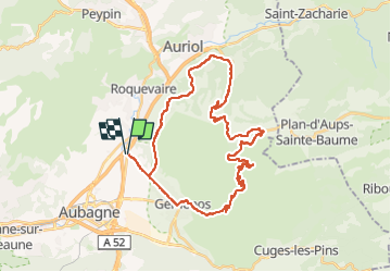
14.2 km | 24 km-effort
7h 0min
Yes
Trail Walking Aubagne - font de mai de Jean claude - Photo
Walking
Coryphene

Walking

Difficult
(1)
Aubagne, Provence-Alpes-Côte d'Azur, Bouches-du-Rhône, France
8.8 km | 12.8 km-effort
2h 54min
Yes
Trail Walking Gémenos - St Pons Le Fauge Glacière  - Photo
Walking
GUIDE
lhomme.ph

Walking

Difficult
(1)
Gémenos, Provence-Alpes-Côte d'Azur, Bouches-du-Rhône, France
11.7 km | 18.6 km-effort
3h 56min
Yes
Trail Walking Gémenos - autour de Saint pons - Photo
Walking
Coryphene

Walking

Easy
(1)
Gémenos, Provence-Alpes-Côte d'Azur, Bouches-du-Rhône, France
11.6 km | 16.1 km-effort
3h 46min
Yes
Trail Mountain bike Gémenos - Gémenos - La Grande Baume - Photo
Mountain bike
tracegps

Mountain bike

Difficult
(1)
Gémenos, Provence-Alpes-Côte d'Azur, Bouches-du-Rhône, France
18.4 km | 29 km-effort
3h 30min
Yes
Trail Walking Roquevaire - Garlaban au départ de Lascours  - Photo
Walking
GUIDE
nadinebondoux

Walking

Difficult
Roquevaire, Provence-Alpes-Côte d'Azur, Bouches-du-Rhône, France
15.6 km | 26 km-effort
6h 1min
Yes
Trail Walking Gémenos - abbaye de St Pons - Photo
Walking
GUIDE
amiral13

Walking

Very easy
Gémenos, Provence-Alpes-Côte d'Azur, Bouches-du-Rhône, France
5 km | 6.4 km-effort
1h 40min
Yes
Trail Walking Roquevaire - le mont du marseillais par le grand Vallon - Photo
Walking
GUIDE
amiral13

Walking

Difficult
Roquevaire, Provence-Alpes-Côte d'Azur, Bouches-du-Rhône, France
9.9 km | 15.9 km-effort
4h 50min
Yes
Trail Walking Roquevaire - Le Garlaban par le Grand Vallon - Photo
Walking
ARPF

Walking

Difficult
(1)
Roquevaire, Provence-Alpes-Côte d'Azur, Bouches-du-Rhône, France
10.1 km | 18.7 km-effort
3h 49min
Yes


Close
My subscriptions