Trail  Ussel - 2023-05-05_23h07m14_Cirkwi-La_cime_des_bois - Photo

2023-05-05_23h07m14_Cirkwi-La_cime_des_bois

 phisa
phisa

User

© OpenStreetMap contributors
Length
Length
49 km
Max alt
Max alt
863 m
Uphill gradient
Uphill gradient
1166 m
Km-Effort
Km-Effort  
64 km
Min alt
Min alt
595 m
Downhill gradient
Downhill gradient
1168 m
Boucle
Boucle
Yes
Creation date :
2023-05-05 21:07:14.446
Updated on :
2023-05-05 21:07:15.428

(0 Reviews)


Scan this QR Code to open this trail in the SityTrail application

FREE GPS app for hiking

Logo SityTrail SityTrail

IGN / Geographical institutes

Download SityTrail from the App Store Download SityTrail from Google Play

Logo SityTrail SityTrail World

The world is yours!

Download SityTrail from the App Store Download SityTrail from Google Play Download SityTrail on Huawei AppGallery

About

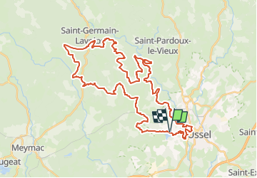
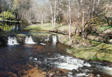
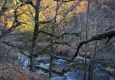
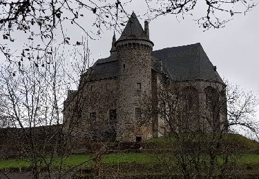
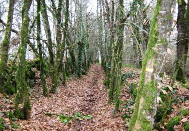
Trail of 49 km to be discovered at New Aquitaine, Corrèze, Ussel. This trail is proposed by phisa.

Description

Espace VTT Haute-Corrèze, circuit VTT n°7 (50 km) au départ de l'étang de Ponty. Ce circuit fait partie de la base VTT FFVélo Haute-Corrèze, plus grand espace VTT de France avec ses 1000 km de circuits balisés. Du même point de départ, le circuit 5 est un raccourci de cet itinéraire alors que les plus sportifs pourront enchaîner avec la boucle du circuit 6 au niveau de Chaverochette (compter 18 km supplémentaires). Bien que classé noir, ce circuit ne comportant pas de difficulté technique, il est adapté pour une longue sortie roulante. Des parcours sur plusieurs jours sont possibles avec des solutions d’hébergement à proximité (campings, gîtes, chambres d’hôtes, village vacances…). Point de location de VTT : toute l'année au château de la Diège, en été à Sèchemailles.

Elevation profile

Positioning

Country:
France
Region :
New Aquitaine
Department/Province :
Corrèze
Municipality :
Ussel
Location:
Unknown
Start:(Dec)
Start:(UTM)
444105 ; 5043979 (31T) N.

Trails nearby

Trail sport Chaveroche - F 2024 Chaveroche - Photo
sport
hl44lv

sport

Very easy
Chaveroche, New Aquitaine, Corrèze, France
11.4 km | 15.5 km-effort
Unknown
Yes
Trail Walking Saint-Angel - Fred st angel - Photo
Walking
arnoultjf

Walking

Medium
Saint-Angel, New Aquitaine, Corrèze, France
8.4 km | 11.8 km-effort
2h 48min
Yes
Trail Walking Saint-Angel - Saint-Angel, le prieuré 1 - Photo
Walking
famille.scharf

Walking

Medium
Saint-Angel, New Aquitaine, Corrèze, France
6 km | 8 km-effort
1h 33min
Yes
Trail Walking Saint-Angel - Fred St Angel - Photo
Walking
arnoultjf

Walking

Very easy
Saint-Angel, New Aquitaine, Corrèze, France
10.5 km | 13.7 km-effort
3h 32min
Yes
Trail Walking Chaveroche - Le Chassaing - Photo
Walking
famille.scharf

Walking

Chaveroche, New Aquitaine, Corrèze, France
5.5 km | 7.1 km-effort
2h 1min
Yes
Trail Walking Saint-Angel - Boucle saint-angel - Photo
Walking
viam19

Walking

Medium
Saint-Angel, New Aquitaine, Corrèze, France
14.7 km | 19.3 km-effort
4h 29min
Yes
Trail Walking Saint-Angel - Le Prieuré de Saint Angel - variante famille - Saint Angel - Pays de Haute Corrèze  - Photo
Walking
tracegps

Walking

Easy
Saint-Angel, New Aquitaine, Corrèze, France
4.4 km | 6.1 km-effort
1h 0min
Yes
Trail Mountain bike Saint-Angel - Le Prieuré de Saint Angel - Pays de Haute Corrèze - Photo
Mountain bike
tracegps

Mountain bike

Medium
Saint-Angel, New Aquitaine, Corrèze, France
12 km | 15.5 km-effort
1h 0min
Yes
Trail Walking Saint-Angel - Le Prieuré de Saint Angel - Pays de Haute Corrèze - Photo
Walking
tracegps

Walking

Medium
Saint-Angel, New Aquitaine, Corrèze, France
12 km | 15.5 km-effort
3h 0min
Yes


Close
My subscriptions