![](/images/other/stat-length.png)
![Trail Walking Pelm - Dolomites de Gerolstein (Eifel) - Photo](https://media.geolcdn.com/t/1900/400/bc5670f7-5ecd-4c4d-8448-5f29a634bb1b.jpeg&format=pjpeg&maxdim=2)
Dolomites de Gerolstein (Eifel)
dauzata
User
![Length](/images/other/stat-length.png)
Length
10.7 km
![Max alt](https://static1.geolcdn.com/siteimages/upload/files/1508320355ic_sort_altitude_max_24dp.png)
Max alt
523 m
![Uphill gradient](https://static1.geolcdn.com/siteimages/upload/files/1508320355ic_sort_den_pos_24dp.png)
Uphill gradient
316 m
![Km-Effort](/images/other/stat-length.png)
Km-Effort
14.9 km
![Min alt](https://static1.geolcdn.com/siteimages/upload/files/1508320355ic_sort_altitude_min_24dp.png)
Min alt
400 m
![Downhill gradient](https://static1.geolcdn.com/siteimages/upload/files/1508320355ic_sort_den_neg_24dp.png)
Downhill gradient
313 m
![Boucle](https://static1.geolcdn.com/siteimages/upload/files/16400158638029165_repeat_loop_refresh_sync_direction_icon.png)
Boucle
Yes
Creation date :
2023-05-01 08:46:10.0
Updated on :
2023-05-04 20:19:14.897
![Walking](https://static1.geolcdn.com/sitytour/trail-icons/101.png)
3h23
Difficulty : Easy
![Scan this QR Code to open this trail in the SityTrail application](https://capi.geolives.com/qq0zvz2zws4bq2lad0pu/sitytour/trails/3642868/qr.png?size=200)
FREE GPS app for hiking
About
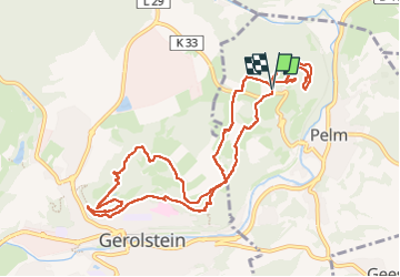
Trail Walking of 10.7 km to be discovered at Rhineland-Palatinate, Landkreis Vulkaneifel, Pelm. This trail is proposed by dauzata.
Description
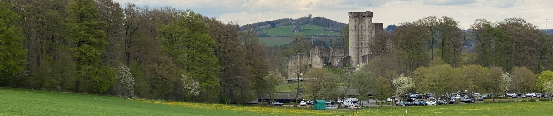
Départ: Parking du château de Kasselburg
ATTENTION: la fin du parcours se situe dans le parc à loups et aigles de Kasselburg qui est payant (10€ en mai 2023)
Positioning
Country:
Germany
Region :
Rhineland-Palatinate
Department/Province :
Landkreis Vulkaneifel
Municipality :
Pelm
Location:
Unknown
Start:(Dec)
Start:(UTM)
334718 ; 5567713 (32U) N.
Comments
Trails nearby
![Trail On foot Gerolstein - Gerolsteiner Keltenpfad - Photo](https://media.geolcdn.com/t/375/260/702d393f-231f-41c2-907f-13868b96b901.jpeg&format=jpg&maxdim=2)
![On foot On foot](https://static1.geolcdn.com/sitytour/trail-icons/100.png)
Gerolsteiner Keltenpfad
On foot
Easy
Gerolstein,
Rhineland-Palatinate,
Landkreis Vulkaneifel,
Germany
![](/images/other/stat-length.png)
9 km | 13.1 km-effort
2h 59min
![](https://static1.geolcdn.com/siteimages/upload/files/16400158638029165_repeat_loop_refresh_sync_direction_icon.png)
Yes
![Trail On foot Gerolstein - Gerolsteiner Felsenpfad - Photo](https://media.geolcdn.com/t/375/260/15a3db22-5820-45b4-9fd9-4f37b568139b.jpeg&format=jpg&maxdim=2)
![On foot On foot](https://static1.geolcdn.com/sitytour/trail-icons/100.png)
Gerolsteiner Felsenpfad
On foot
Easy
Gerolstein,
Rhineland-Palatinate,
Landkreis Vulkaneifel,
Germany
![](/images/other/stat-length.png)
8.5 km | 12.5 km-effort
2h 50min
![](https://static1.geolcdn.com/siteimages/upload/files/16400158638029165_repeat_loop_refresh_sync_direction_icon.png)
Yes
![Trail Walking Gerolstein - Eifelsteig Gerolstein - Photo](https://media.geolcdn.com/t/375/260/6e15d726-e12b-4c8e-9752-428fed227476.jpg&format=jpg&maxdim=2)
![Walking Walking](https://static1.geolcdn.com/sitytour/trail-icons/101.png)
Eifelsteig Gerolstein
Walking
Medium
Gerolstein,
Rhineland-Palatinate,
Landkreis Vulkaneifel,
Germany
![](/images/other/stat-length.png)
9 km | 13.1 km-effort
1h 37min
![](https://static1.geolcdn.com/siteimages/upload/files/16400158638029165_repeat_loop_refresh_sync_direction_icon.png)
Yes
![Trail Walking Gerolstein - Duitsland - Buscheich in Eiffel - Photo](https://media.geolcdn.com/t/375/260/ext.jpg?maxdim=2&url=https%3A%2F%2Fstatic1.geolcdn.com%2Fsiteimages%2Fupload%2Ffiles%2F1553511878bg_sport_marche.png)
![Walking Walking](https://static1.geolcdn.com/sitytour/trail-icons/101.png)
Duitsland - Buscheich in Eiffel
Walking
Very easy
Gerolstein,
Rhineland-Palatinate,
Landkreis Vulkaneifel,
Germany
![](/images/other/stat-length.png)
14.7 km | 21 km-effort
Unknown
![](https://static1.geolcdn.com/siteimages/upload/files/16400158638029165_repeat_loop_refresh_sync_direction_icon.png)
Yes
![Trail Walking Gerolstein - ESt-10 - Photo](https://media.geolcdn.com/t/375/260/ext.jpg?maxdim=2&url=https%3A%2F%2Fstatic1.geolcdn.com%2Fsiteimages%2Fupload%2Ffiles%2F1553511878bg_sport_marche.png)
![Walking Walking](https://static1.geolcdn.com/sitytour/trail-icons/101.png)
ESt-10
Walking
Medium
Gerolstein,
Rhineland-Palatinate,
Landkreis Vulkaneifel,
Germany
![](/images/other/stat-length.png)
25 km | 36 km-effort
7h 19min
![](https://static1.geolcdn.com/siteimages/upload/files/16400158638029165_repeat_loop_refresh_sync_direction_icon.png)
No
![Trail sport Gerolstein - Gerolsteiner Stausee - Photo](https://media.geolcdn.com/t/375/260/ext.jpg?maxdim=2&url=https%3A%2F%2Fsecurestorage.geolives.com%2Fsitytour%2Ftrail-bg%2Fdefault.jpg)
Gerolsteiner Stausee
sport
Very easy
Gerolstein,
Rhineland-Palatinate,
Landkreis Vulkaneifel,
Germany
![](/images/other/stat-length.png)
8.8 km | 12.1 km-effort
Unknown
![](https://static1.geolcdn.com/siteimages/upload/files/16400158638029165_repeat_loop_refresh_sync_direction_icon.png)
Yes
![Trail Walking Berlingen - 221007 balade autour de Berlingen - Photo](https://media.geolcdn.com/t/375/260/ext.jpg?maxdim=2&url=https%3A%2F%2Fstatic1.geolcdn.com%2Fsiteimages%2Fupload%2Ffiles%2F1553511878bg_sport_marche.png)
![Walking Walking](https://static1.geolcdn.com/sitytour/trail-icons/101.png)
221007 balade autour de Berlingen
Walking
Medium
Berlingen,
Rhineland-Palatinate,
Landkreis Vulkaneifel,
Germany
![](/images/other/stat-length.png)
6.3 km | 8.4 km-effort
1h 26min
![](https://static1.geolcdn.com/siteimages/upload/files/16400158638029165_repeat_loop_refresh_sync_direction_icon.png)
Yes
![Trail Other activity Gerolstein - Duitsland - Eifelsteig 08: Gerolstein - Daun - Photo](https://media.geolcdn.com/t/375/260/ext.jpg?maxdim=2&url=https%3A%2F%2Fstatic1.geolcdn.com%2Fsiteimages%2Fupload%2Ffiles%2F1545311037marcheuse_200dpi.jpg)
![Other activity Other activity](https://static1.geolcdn.com/sitytour/trail-icons/900.png)
Duitsland - Eifelsteig 08: Gerolstein - Daun
Other activity
Medium
Gerolstein,
Rhineland-Palatinate,
Landkreis Vulkaneifel,
Germany
![](/images/other/stat-length.png)
25 km | 36 km-effort
7h 32min
![](https://static1.geolcdn.com/siteimages/upload/files/16400158638029165_repeat_loop_refresh_sync_direction_icon.png)
No