Trail Walking Moncoutant-sur-Sèvre - Chante merle - Photo
 viaul
viaul

User GUIDE

© OpenStreetMap contributors
Length
Length
12.2 km
Max alt
Max alt
226 m
Uphill gradient
Uphill gradient
134 m
Km-Effort
Km-Effort  
14 km
Min alt
Min alt
185 m
Downhill gradient
Downhill gradient
134 m
Boucle
Boucle
Yes
Creation date :
2023-04-16 12:16:55.0
Updated on :
2023-04-30 11:55:11.301

(0 Reviews)

Walking
Walking
3h04
Difficulty : Easy

Scan this QR Code to open this trail in the SityTrail application

FREE GPS app for hiking

Logo SityTrail SityTrail

IGN / Geographical institutes

Download SityTrail from the App Store Download SityTrail from Google Play

Logo SityTrail SityTrail World

The world is yours!

Download SityTrail from the App Store Download SityTrail from Google Play Download SityTrail on Huawei AppGallery

About

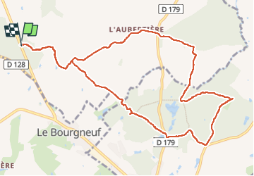
Trail Walking of 12.2 km to be discovered at New Aquitaine, Deux-Sèvres, Moncoutant-sur-Sèvre. This trail is proposed by viaul.

Elevation profile

Photos

Positioning

Country:
France
Region :
New Aquitaine
Department/Province :
Deux-Sèvres
Municipality :
Moncoutant-sur-Sèvre
Location:
La Chapelle-Saint-Étienne
Start:(Dec)
Start:(UTM)
682854 ; 5169938 (30T) N.

Trails nearby

Trail On foot La Chapelle-aux-Lys - Chemin aux Étoiles - L'histoire de l'Univers - Photo
On foot
GUIDE+

On foot

Easy
La Chapelle-aux-Lys, Pays de la Loire, Vendée, France
4.3 km | 5.3 km-effort
1h 12min
No
Trail Walking Moncoutant-sur-Sèvre - Rando 17km A-R de la forêt de l'aventure - Photo
Walking
dudu79

Walking

Very difficult
(1)
Moncoutant-sur-Sèvre, New Aquitaine, Deux-Sèvres, France
17.5 km | 21 km-effort
4h 50min
Yes
Trail Walking Moncoutant-sur-Sèvre - La Bonneliere - Photo
Walking
Bushiben

Walking

Very easy
Moncoutant-sur-Sèvre, New Aquitaine, Deux-Sèvres, France
12.4 km | 14.2 km-effort
4h 59min
Yes
Trail Walking Moncoutant-sur-Sèvre - Forêt de l aventure  - Photo
Walking
GUIDE
viaul

Walking

Easy
Moncoutant-sur-Sèvre, New Aquitaine, Deux-Sèvres, France
19.8 km | 23 km-effort
5h 31min
Yes
Trail Walking Moncoutant-sur-Sèvre - Chante beau merle st Paul - Photo
Walking
GUIDE
viaul

Walking

Easy
Moncoutant-sur-Sèvre, New Aquitaine, Deux-Sèvres, France
18.3 km | 22 km-effort
4h 8min
Yes
Trail On foot Moncoutant-sur-Sèvre - rando du 23 mai 2021 - Photo
On foot
dudu79

On foot

Medium
Moncoutant-sur-Sèvre, New Aquitaine, Deux-Sèvres, France
21 km | 26 km-effort
5h 54min
Yes
Trail Cycle Moncoutant-sur-Sèvre - Guérinière Bressuire 2 - Photo
Cycle
Ceclm

Cycle

Very easy
Moncoutant-sur-Sèvre, New Aquitaine, Deux-Sèvres, France
19.3 km | 21 km-effort
1h 0min
No
Trail Quad La Chapelle-aux-Lys - rando 7 oct 23 - Photo
Quad
rabal85

Quad

Very easy
La Chapelle-aux-Lys, Pays de la Loire, Vendée, France
85 km | 102 km-effort
3h 8min
No
Trail 4x4 La Chapelle-aux-Lys - semi nocturne  - Photo
4x4
favraux

4x4

Very easy
La Chapelle-aux-Lys, Pays de la Loire, Vendée, France
108 km | 129 km-effort
15h 31min
No


Close
My subscriptions