![](/images/other/stat-length.png)
![Trail Walking Grez-Doiceau - ARCHENNES _ Marche Fédérale _ BBW _ 30/04/2023. - Photo](https://media.geolcdn.com/t/1900/400/ext.pjpeg?maxdim=2&url=https%3A%2F%2Fstatic1.geolcdn.com%2Fsiteimages%2Fupload%2Ffiles%2F1553511878bg_sport_marche.png)
ARCHENNES _ Marche Fédérale _ BBW _ 30/04/2023.
jeangulu
User
![Length](/images/other/stat-length.png)
Length
14.7 km
![Max alt](https://static1.geolcdn.com/siteimages/upload/files/1508320355ic_sort_altitude_max_24dp.png)
Max alt
108 m
![Uphill gradient](https://static1.geolcdn.com/siteimages/upload/files/1508320355ic_sort_den_pos_24dp.png)
Uphill gradient
198 m
![Km-Effort](/images/other/stat-length.png)
Km-Effort
17.3 km
![Min alt](https://static1.geolcdn.com/siteimages/upload/files/1508320355ic_sort_altitude_min_24dp.png)
Min alt
29 m
![Downhill gradient](https://static1.geolcdn.com/siteimages/upload/files/1508320355ic_sort_den_neg_24dp.png)
Downhill gradient
198 m
![Boucle](https://static1.geolcdn.com/siteimages/upload/files/16400158638029165_repeat_loop_refresh_sync_direction_icon.png)
Boucle
Yes
Creation date :
2023-04-30 07:14:46.815
Updated on :
2023-04-30 10:44:40.429
![Walking](https://static1.geolcdn.com/sitytour/trail-icons/101.png)
3h29
Difficulty : Medium
![Scan this QR Code to open this trail in the SityTrail application](https://capi.geolives.com/qq0zvz2zws4bq2lad0pu/sitytour/trails/3641061/qr.png?size=200)
FREE GPS app for hiking
About
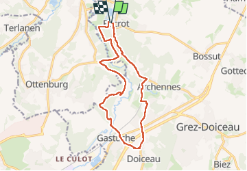
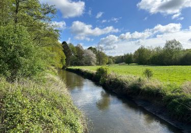
Trail Walking of 14.7 km to be discovered at Wallonia, Walloon Brabant, Grez-Doiceau. This trail is proposed by jeangulu.
Description
Point de départ : Térrain de football de Pécrot.
Organisateur : BBW 017 _ AMICALE MARCHEURS INDÉPENDANTS..
Carte IGN : 32/6.
Thème : Marche de la Saint Georges.
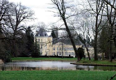
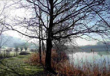
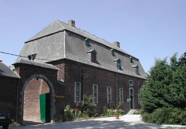
Très beau parcours.
Positioning
Country:
Belgium
Region :
Wallonia
Department/Province :
Walloon Brabant
Municipality :
Grez-Doiceau
Location:
Unknown
Start:(Dec)
Start:(UTM)
616214 ; 5625749 (31U) N.
Comments
Trails nearby
![Trail Walking Grez-Doiceau - GG-Bw-01_Archennes - Wavre - Photo](https://media.geolcdn.com/t/375/260/290bb459-f7c0-458a-900e-424f97fa157f.jpg&format=jpg&maxdim=2)
![Walking Walking](https://static1.geolcdn.com/sitytour/trail-icons/101.png)
GG-Bw-01_Archennes - Wavre
Walking
Very difficult
(7)
Grez-Doiceau,
Wallonia,
Walloon Brabant,
Belgium
![](/images/other/stat-length.png)
23 km | 28 km-effort
5h 59min
![](https://static1.geolcdn.com/siteimages/upload/files/16400158638029165_repeat_loop_refresh_sync_direction_icon.png)
No
![Trail Walking Grez-Doiceau - RB-BW-06-raccourci 2 - De rivières en collines, au nord de Wavre - Photo](https://media.geolcdn.com/t/375/260/ext.jpg?maxdim=2&url=https%3A%2F%2Fservices.sitytrail.com%2FGeolivesWS%2FDownloadMedia.ashx%3FTrailID%3D219721%26Media%3D21b977c1-3cb7-4170-9cd8-fae609cd623c.jpg)
![Walking Walking](https://static1.geolcdn.com/sitytour/trail-icons/101.png)
RB-BW-06-raccourci 2 - De rivières en collines, au nord de Wavre
Walking
Easy
(5)
Grez-Doiceau,
Wallonia,
Walloon Brabant,
Belgium
![](/images/other/stat-length.png)
7 km | 8.4 km-effort
1h 49min
![](https://static1.geolcdn.com/siteimages/upload/files/16400158638029165_repeat_loop_refresh_sync_direction_icon.png)
Yes
![Trail Walking Grez-Doiceau - RB-BW-06-raccourci 1 - De rivières en collines, au nord de Wavre - Photo](https://media.geolcdn.com/t/375/260/ext.jpg?maxdim=2&url=https%3A%2F%2Fservices.sitytrail.com%2FGeolivesWS%2FDownloadMedia.ashx%3FTrailID%3D219602%26Media%3D265c6b21-1802-4143-b5b1-44460e289445.jpg)
![Walking Walking](https://static1.geolcdn.com/sitytour/trail-icons/101.png)
RB-BW-06-raccourci 1 - De rivières en collines, au nord de Wavre
Walking
Easy
(10)
Grez-Doiceau,
Wallonia,
Walloon Brabant,
Belgium
![](/images/other/stat-length.png)
14.6 km | 17.1 km-effort
3h 52min
![](https://static1.geolcdn.com/siteimages/upload/files/16400158638029165_repeat_loop_refresh_sync_direction_icon.png)
Yes
![Trail Walking Grez-Doiceau - RB-BW-06 - De rivières en collines, au nord de Wavre - Photo](https://media.geolcdn.com/t/375/260/ext.jpg?maxdim=2&url=https%3A%2F%2Fservices.sitytrail.com%2FGeolivesWS%2FDownloadMedia.ashx%3FTrailID%3D179581%26Media%3D21b977c1-3cb7-4170-9cd8-fae609cd623c.jpg)
![Walking Walking](https://static1.geolcdn.com/sitytour/trail-icons/101.png)
RB-BW-06 - De rivières en collines, au nord de Wavre
Walking
Easy
(9)
Grez-Doiceau,
Wallonia,
Walloon Brabant,
Belgium
![](/images/other/stat-length.png)
24 km | 28 km-effort
5h 29min
![](https://static1.geolcdn.com/siteimages/upload/files/16400158638029165_repeat_loop_refresh_sync_direction_icon.png)
Yes
![Trail Walking Grez-Doiceau - RB-BW-04 - À la rencontre du Train et de ses affluents - Photo](https://media.geolcdn.com/t/375/260/ext.jpg?maxdim=2&url=https%3A%2F%2Fservices.sitytrail.com%2FGeolivesWS%2FDownloadMedia.ashx%3FTrailID%3D179579%26Media%3D90329f99-636a-44e0-b5b4-fdd385982abd.jpg)
![Walking Walking](https://static1.geolcdn.com/sitytour/trail-icons/101.png)
RB-BW-04 - À la rencontre du Train et de ses affluents
Walking
Easy
(9)
Grez-Doiceau,
Wallonia,
Walloon Brabant,
Belgium
![](/images/other/stat-length.png)
24 km | 29 km-effort
6h 10min
![](https://static1.geolcdn.com/siteimages/upload/files/16400158638029165_repeat_loop_refresh_sync_direction_icon.png)
Yes
![Trail Walking Grez-Doiceau - RB-BW-04 - raccourci - À la rencontre du Train et de ses affluents - Photo](https://media.geolcdn.com/t/375/260/ext.jpg?maxdim=2&url=https%3A%2F%2Fservices.sitytrail.com%2FGeolivesWS%2FDownloadMedia.ashx%3FTrailID%3D219237%26Media%3D1db4b8b8-6f6c-4aeb-8f88-f3a2cc3907ce.jpg)
![Walking Walking](https://static1.geolcdn.com/sitytour/trail-icons/101.png)
RB-BW-04 - raccourci - À la rencontre du Train et de ses affluents
Walking
Easy
(9)
Grez-Doiceau,
Wallonia,
Walloon Brabant,
Belgium
![](/images/other/stat-length.png)
16.3 km | 19.2 km-effort
4h 10min
![](https://static1.geolcdn.com/siteimages/upload/files/16400158638029165_repeat_loop_refresh_sync_direction_icon.png)
Yes
![Walking Walking](https://static1.geolcdn.com/sitytour/trail-icons/101.png)
GG2-Bw-21_Pécrot-Genval_2021-11-04
Walking
Very difficult
(3)
Grez-Doiceau,
Wallonia,
Walloon Brabant,
Belgium
![](/images/other/stat-length.png)
26 km | 31 km-effort
7h 7min
![](https://static1.geolcdn.com/siteimages/upload/files/16400158638029165_repeat_loop_refresh_sync_direction_icon.png)
No
![Walking Walking](https://static1.geolcdn.com/sitytour/trail-icons/101.png)
#240524b - Forêt de Meerdael, drève et étang de Warande
Walking
Medium
(1)
Beauvechain,
Wallonia,
Walloon Brabant,
Belgium
![](/images/other/stat-length.png)
6.9 km | 8.2 km-effort
1h 51min
![](https://static1.geolcdn.com/siteimages/upload/files/16400158638029165_repeat_loop_refresh_sync_direction_icon.png)
Yes
![Walking Walking](https://static1.geolcdn.com/sitytour/trail-icons/101.png)
#230220 - Terlanen, Schaatbroekbos, GR579
Walking
Medium
(2)
Overijse,
Flanders,
Flemish Brabant,
Belgium
![](/images/other/stat-length.png)
7.2 km | 8.4 km-effort
1h 55min
![](https://static1.geolcdn.com/siteimages/upload/files/16400158638029165_repeat_loop_refresh_sync_direction_icon.png)
Yes