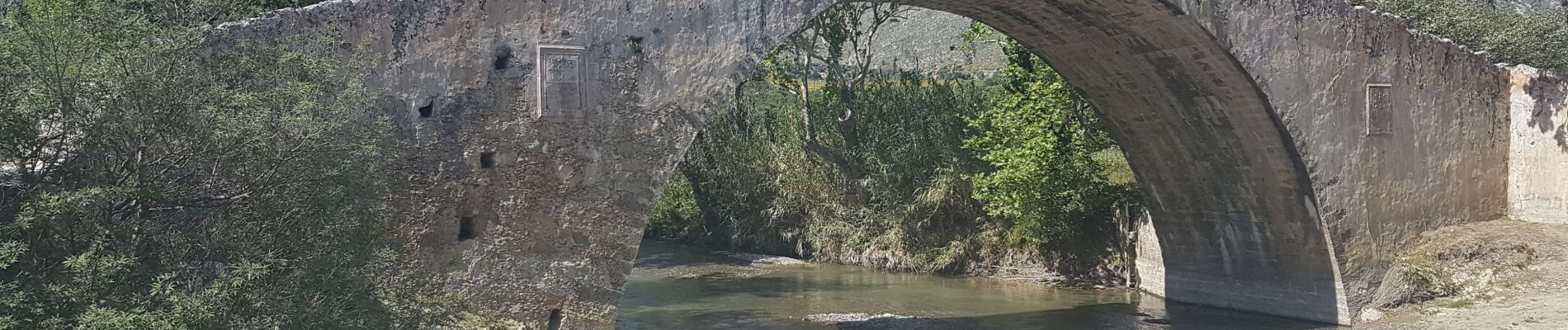
![](/images/other/stat-length.png)
![Trail Walking Unknown - La plage de Préveli depuis le pont Vénitien (taverne Gefyra) (Rother n°38) - Photo](https://media.geolcdn.com/t/1900/400/62715269-8c95-41bb-b7d1-b652001716ab.jpg&format=pjpeg&maxdim=2)
La plage de Préveli depuis le pont Vénitien (taverne Gefyra) (Rother n°38)
Bart2015
User
![Length](/images/other/stat-length.png)
Length
8 km
![Max alt](https://static1.geolcdn.com/siteimages/upload/files/1508320355ic_sort_altitude_max_24dp.png)
Max alt
124 m
![Uphill gradient](https://static1.geolcdn.com/siteimages/upload/files/1508320355ic_sort_den_pos_24dp.png)
Uphill gradient
280 m
![Km-Effort](/images/other/stat-length.png)
Km-Effort
11.8 km
![Min alt](https://static1.geolcdn.com/siteimages/upload/files/1508320355ic_sort_altitude_min_24dp.png)
Min alt
2 m
![Downhill gradient](https://static1.geolcdn.com/siteimages/upload/files/1508320355ic_sort_den_neg_24dp.png)
Downhill gradient
285 m
![Boucle](https://static1.geolcdn.com/siteimages/upload/files/16400158638029165_repeat_loop_refresh_sync_direction_icon.png)
Boucle
Yes
Creation date :
2023-04-29 07:57:47.704
Updated on :
2023-05-03 18:38:27.244
![Walking](https://static1.geolcdn.com/sitytour/trail-icons/101.png)
2h40
Difficulty : Medium
![Scan this QR Code to open this trail in the SityTrail application](https://capi.geolives.com/qq0zvz2zws4bq2lad0pu/sitytour/trails/3640374/qr.png?size=200)
FREE GPS app for hiking
About
Trail Walking of 8 km to be discovered at Region of Crete, Rethymno Regional Unit. This trail is proposed by Bart2015.
Description
Cette randonnée permet de rejoindre la belle plage de sable fin inaccessible en voiture. Une taverne est installée à proximité et permet de se restaurer, accès en traversant le petit cours d'eau se jetant à la mer.
Bonne rando et baignade ...
Positioning
Country:
Greece
Region :
Region of Crete
Department/Province :
Rethymno Regional Unit
Municipality :
Unknown
Location:
Unknown
Start:(Dec)
Start:(UTM)
269311 ; 3895229 (35S) N.
Comments
Trails nearby
![Trail Walking - Crète-Préveli 2-4-2018 - Photo](https://media.geolcdn.com/t/375/260/ext.jpg?maxdim=2&url=https%3A%2F%2Fstatic1.geolcdn.com%2Fsiteimages%2Fupload%2Ffiles%2F1553511878bg_sport_marche.png)
![Walking Walking](https://static1.geolcdn.com/sitytour/trail-icons/101.png)
Crète-Préveli 2-4-2018
Walking
Easy
,
Region of Crete,
Rethymno Regional Unit,
Greece
![](/images/other/stat-length.png)
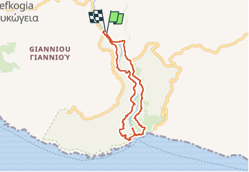
9.1 km | 14.3 km-effort
2h 53min
![](https://static1.geolcdn.com/siteimages/upload/files/16400158638029165_repeat_loop_refresh_sync_direction_icon.png)
Yes
![Trail Walking - prevali - Photo](https://media.geolcdn.com/t/375/260/ext.jpg?maxdim=2&url=https%3A%2F%2Fstatic1.geolcdn.com%2Fsiteimages%2Fupload%2Ffiles%2F1553511878bg_sport_marche.png)
![Walking Walking](https://static1.geolcdn.com/sitytour/trail-icons/101.png)
prevali
Walking
Easy
,
Region of Crete,
Rethymno Regional Unit,
Greece
![](/images/other/stat-length.png)
577 m | 1.6 km-effort
19min
![](https://static1.geolcdn.com/siteimages/upload/files/16400158638029165_repeat_loop_refresh_sync_direction_icon.png)
No