![](/images/other/stat-length.png)
![Trail Walking Waremme - WAREMME _ Marche Fédérale _ LG _ 29/04/2023 - Photo](https://media.geolcdn.com/t/1900/400/5f155266-fac2-4ae1-b976-114cbadef2b5.jpg&format=pjpeg&maxdim=2)
WAREMME _ Marche Fédérale _ LG _ 29/04/2023
jeangulu
User
![Length](/images/other/stat-length.png)
Length
21 km
![Max alt](https://static1.geolcdn.com/siteimages/upload/files/1508320355ic_sort_altitude_max_24dp.png)
Max alt
137 m
![Uphill gradient](https://static1.geolcdn.com/siteimages/upload/files/1508320355ic_sort_den_pos_24dp.png)
Uphill gradient
165 m
![Km-Effort](/images/other/stat-length.png)
Km-Effort
24 km
![Min alt](https://static1.geolcdn.com/siteimages/upload/files/1508320355ic_sort_altitude_min_24dp.png)
Min alt
89 m
![Downhill gradient](https://static1.geolcdn.com/siteimages/upload/files/1508320355ic_sort_den_neg_24dp.png)
Downhill gradient
165 m
![Boucle](https://static1.geolcdn.com/siteimages/upload/files/16400158638029165_repeat_loop_refresh_sync_direction_icon.png)
Boucle
Yes
Creation date :
2023-04-29 08:30:24.808
Updated on :
2023-04-29 13:38:12.179
![Walking](https://static1.geolcdn.com/sitytour/trail-icons/101.png)
5h07
Difficulty : Medium
![Scan this QR Code to open this trail in the SityTrail application](https://capi.geolives.com/qq0zvz2zws4bq2lad0pu/sitytour/trails/3639979/qr.png?size=200)
FREE GPS app for hiking
About
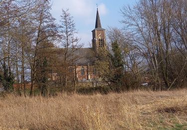
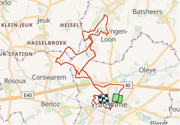
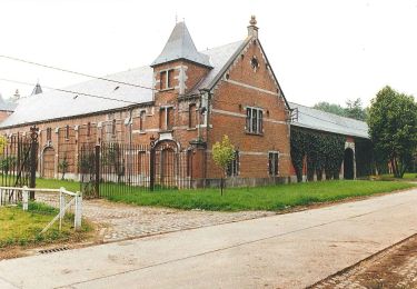
Trail Walking of 21 km to be discovered at Wallonia, Liège, Waremme. This trail is proposed by jeangulu.
Description
Point de départ : Athénée Royal (Secondaire) _ Rue du Casino, 4 _ 4300 _ WAREMME.
Organisateur : LG 138 _ LES AMIS DU TUMULUS.
Carte IGN : 41/3.
44e Marche Internationale de Waremme.
Positioning
Country:
Belgium
Region :
Wallonia
Department/Province :
Liège
Municipality :
Waremme
Location:
Unknown
Start:(Dec)
Start:(UTM)
659307 ; 5618365 (31U) N.
Comments
Trails nearby
![Trail Walking Waremme - WACHNET WAREMME - Photo](https://media.geolcdn.com/t/375/260/9402a055-337f-4143-8a11-4cda7b0783be.png&format=jpg&maxdim=2)
![Walking Walking](https://static1.geolcdn.com/sitytour/trail-icons/101.png)
![Trail Walking Waremme - Cirkwi-Waremme_-_Autour_de_la_Vallée_du_Geer_-_7,1km - Photo](https://media.geolcdn.com/t/375/260/ext.jpg?maxdim=2&url=https%3A%2F%2Fstatic1.geolcdn.com%2Fsiteimages%2Fupload%2Ffiles%2F1553511878bg_sport_marche.png)
![Walking Walking](https://static1.geolcdn.com/sitytour/trail-icons/101.png)
Cirkwi-Waremme_-_Autour_de_la_Vallée_du_Geer_-_7,1km
Walking
Medium
(2)
Waremme,
Wallonia,
Liège,
Belgium
![](/images/other/stat-length.png)
7.1 km | 7.6 km-effort
1h 43min
![](https://static1.geolcdn.com/siteimages/upload/files/16400158638029165_repeat_loop_refresh_sync_direction_icon.png)
Yes
![Trail On foot Heers - Hornbos Groen - Photo](https://media.geolcdn.com/t/375/260/504e6508-a890-4ba4-87e9-eb16d6acfb97.jpeg&format=jpg&maxdim=2)
![On foot On foot](https://static1.geolcdn.com/sitytour/trail-icons/100.png)
![Trail Bicycle tourism Waremme - 2024-05-13_13h13m22_24 05 06 39 Km W-HsG-L-V-W-Fal-Av-L St R-Om-W - Photo](https://media.geolcdn.com/t/375/260/ext.jpg?maxdim=2&url=https%3A%2F%2Fstatic1.geolcdn.com%2Fsiteimages%2Fupload%2Ffiles%2F1524743154velo.jpg)
![Bicycle tourism Bicycle tourism](https://static1.geolcdn.com/sitytour/trail-icons/204.png)
2024-05-13_13h13m22_24 05 06 39 Km W-HsG-L-V-W-Fal-Av-L St R-Om-W
Bicycle tourism
Very easy
(1)
Waremme,
Wallonia,
Liège,
Belgium
![](/images/other/stat-length.png)
39 km | 43 km-effort
Unknown
![](https://static1.geolcdn.com/siteimages/upload/files/16400158638029165_repeat_loop_refresh_sync_direction_icon.png)
Yes
![Trail Walking Waremme - Waremme ( autour de la vallée du Geer) - Photo](https://media.geolcdn.com/t/375/260/e56e87e8-dda3-4c10-9253-9701ae5a37ab.jpg&format=jpg&maxdim=2)
![Walking Walking](https://static1.geolcdn.com/sitytour/trail-icons/101.png)
Waremme ( autour de la vallée du Geer)
Walking
Medium
Waremme,
Wallonia,
Liège,
Belgium
![](/images/other/stat-length.png)
7.6 km | 8.2 km-effort
2h 4min
![](https://static1.geolcdn.com/siteimages/upload/files/16400158638029165_repeat_loop_refresh_sync_direction_icon.png)
Yes
![Trail Walking Waremme - Oleye - bous de Horne - Photo](https://media.geolcdn.com/t/375/260/1a016a95-1857-49e8-88fe-ed16c9189e3e.jpg&format=jpg&maxdim=2)
![Walking Walking](https://static1.geolcdn.com/sitytour/trail-icons/101.png)
Oleye - bous de Horne
Walking
Very easy
Waremme,
Wallonia,
Liège,
Belgium
![](/images/other/stat-length.png)
8.9 km | 9.8 km-effort
2h 12min
![](https://static1.geolcdn.com/siteimages/upload/files/16400158638029165_repeat_loop_refresh_sync_direction_icon.png)
Yes
![Trail Walking Heers - Wikiloc Hornebos (PVDB) - Photo](https://media.geolcdn.com/t/375/260/cd541fb1-7cbb-4bd3-9617-80218f294c48.jpg&format=jpg&maxdim=2)
![Walking Walking](https://static1.geolcdn.com/sitytour/trail-icons/101.png)
Wikiloc Hornebos (PVDB)
Walking
Easy
Heers,
Flanders,
Limburg,
Belgium
![](/images/other/stat-length.png)
8.6 km | 9.8 km-effort
2h 1min
![](https://static1.geolcdn.com/siteimages/upload/files/16400158638029165_repeat_loop_refresh_sync_direction_icon.png)
Yes
![Trail Walking Berloz - Corswarem - Photo](https://media.geolcdn.com/t/375/260/d6b93252-b6ff-4ae4-bd02-4ed611d3318b.jpg&format=jpg&maxdim=2)
![Walking Walking](https://static1.geolcdn.com/sitytour/trail-icons/101.png)
![Trail On foot Berloz - La Kulterkêne - Photo](https://media.geolcdn.com/t/375/260/ext.jpg?maxdim=2&url=https%3A%2F%2Fpivotmedia.tourismewallonie.be%2FANX-0F-00ZU-000H%2FANX-0F-00ZU-000H.jpg)
![On foot On foot](https://static1.geolcdn.com/sitytour/trail-icons/100.png)