


Retour Pavliani Park

boris_pomirol
User
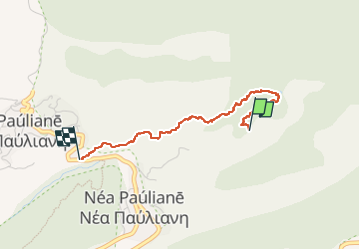

Length
2.8 km

Max alt
936 m

Uphill gradient
180 m
Km-Effort
4.9 km

Min alt
752 m

Downhill gradient
84 m
Boucle
No
Creation date :
2023-04-27 14:01:35.0
Updated on :
2023-04-27 15:31:24.815
1h29
Difficulty : Easy

FREE GPS app for hiking
 SityTrail
IGN / Geographical institutes
SityTrail World
The world is yours!
About
Trail Walking of 2.8 km to be discovered at Thessaly and Central Greece, Phthiotis Regional Unit. This trail is proposed by boris_pomirol.
Positioning
Country:
Greece
Region :
Thessaly and Central Greece
Department/Province :
Phthiotis Regional Unit
Municipality :
Unknown
Location:
Unknown
Start:(Dec)
Start:(UTM)
617832 ; 4288834 (34S) N.
Comments
Trails nearby