Trail  Reuilly - Reuilly 27/04/23 - Photo
 avit46
avit46

User

© OpenStreetMap contributors
Length
Length
16.8 km
Max alt
Max alt
155 m
Uphill gradient
Uphill gradient
157 m
Km-Effort
Km-Effort  
18.9 km
Min alt
Min alt
104 m
Downhill gradient
Downhill gradient
157 m
Boucle
Boucle
Yes
Creation date :
2023-04-27 10:00:04.0
Updated on :
2023-04-27 10:00:05.167

(1 Reviews)


Scan this QR Code to open this trail in the SityTrail application

FREE GPS app for hiking

Logo SityTrail SityTrail

IGN / Geographical institutes

Download SityTrail from the App Store Download SityTrail from Google Play

Logo SityTrail SityTrail World

The world is yours!

Download SityTrail from the App Store Download SityTrail from Google Play Download SityTrail on Huawei AppGallery

About

Trail of 16.8 km to be discovered at Centre-Loire Valley, Indre, Reuilly. This trail is proposed by avit46.

Description

Ça va être lourd

Elevation profile

Positioning

Country:
France
Region :
Centre-Loire Valley
Department/Province :
Indre
Municipality :
Reuilly
Location:
Unknown
Start:(UTM)
427471 ; 5214669 (31T) N.

Comments

Please log in to post a review or rate the element


Trails nearby

Trail sport Reuilly -  - Photo
sport
avit46

sport

Very easy
Reuilly, Centre-Loire Valley, Indre, France
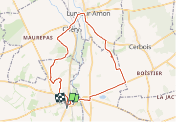
16.2 km | 18.3 km-effort
Unknown
Yes
Trail Mountain bike Reuilly - Reuilly20220501 - Photo
Mountain bike
didier20

Mountain bike

Medium
Reuilly, Centre-Loire Valley, Indre, France
23 km | 26 km-effort
1h 31min
Yes
Trail Walking Reuilly - Reuilly - Photo
Walking
fouetillou

Walking

Medium
Reuilly, Centre-Loire Valley, Indre, France
8.7 km | 10 km-effort
1h 33min
Yes


Close
My subscriptions