![](/images/other/stat-length.png)
![Trail Walking Blegny - 20230427 - Balade ornithologique Saive - 5.3 Km - Photo](https://media.geolcdn.com/t/1900/400/36f113ee-aa2b-4397-aee2-55c35bbd671c.jpeg&format=pjpeg&maxdim=2)
20230427 - Balade ornithologique Saive - 5.3 Km
pierreh01
User GUIDE
![Length](/images/other/stat-length.png)
![Max alt](https://static1.geolcdn.com/siteimages/upload/files/1508320355ic_sort_altitude_max_24dp.png)
![Uphill gradient](https://static1.geolcdn.com/siteimages/upload/files/1508320355ic_sort_den_pos_24dp.png)
![Km-Effort](/images/other/stat-length.png)
![Min alt](https://static1.geolcdn.com/siteimages/upload/files/1508320355ic_sort_altitude_min_24dp.png)
![Downhill gradient](https://static1.geolcdn.com/siteimages/upload/files/1508320355ic_sort_den_neg_24dp.png)
![Boucle](https://static1.geolcdn.com/siteimages/upload/files/16400158638029165_repeat_loop_refresh_sync_direction_icon.png)
![Walking](https://static1.geolcdn.com/sitytour/trail-icons/101.png)
2h29
Difficulty : Medium
![Scan this QR Code to open this trail in the SityTrail application](https://capi.geolives.com/qq0zvz2zws4bq2lad0pu/sitytour/trails/3637140/qr.png?size=200)
FREE GPS app for hiking
About
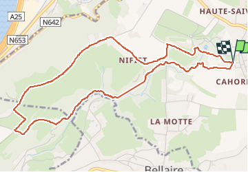
Trail Walking of 5.3 km to be discovered at Wallonia, Liège, Blegny. This trail is proposed by pierreh01.
Description
Jeudi 27 avril 2023 : Balade mensuelle ornithologique.
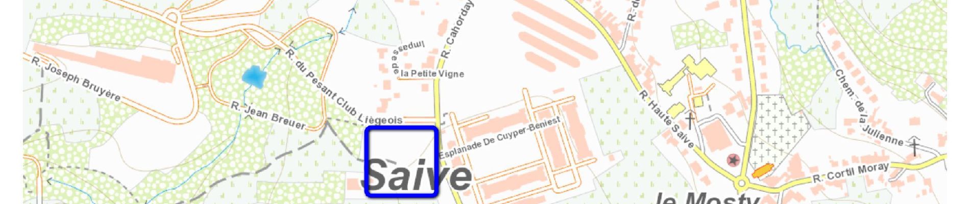
Sous la conduite de notre Roger traditionnel, balade ornithologique de l'UCTL Plateau de Herve au départ du parking de l'ancienne caserne de Saive.
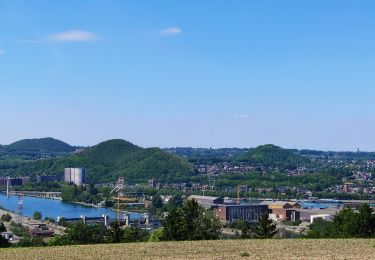
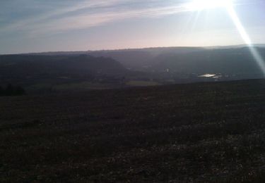
Balade à l'écoute de toutes sortes d'oiseaux, avec parfois la chance de les apercevoir.
Distance mesurée avec Sity Trail, semblant plus proche de la réalité.
Positioning
Comments
Trails nearby
![Trail Walking Fléron - 2024-06-16_18h18m53_1402.gpx.xml - Photo](https://media.geolcdn.com/t/375/260/65875cd7-f353-4090-b6ef-a8656311fae6.jpg&format=jpg&maxdim=2)
![Walking Walking](https://static1.geolcdn.com/sitytour/trail-icons/101.png)
Walking
![](/images/other/stat-length.png)
![](https://static1.geolcdn.com/siteimages/upload/files/16400158638029165_repeat_loop_refresh_sync_direction_icon.png)
![Trail Walking Blegny - 2023-07-28_14h00m33_1702.gpx.xml - Photo](https://media.geolcdn.com/t/375/260/08e717c2-a47c-47f0-9a4e-fb7b564b3f18.jpg&format=jpg&maxdim=2)
![Walking Walking](https://static1.geolcdn.com/sitytour/trail-icons/101.png)
Walking
![](/images/other/stat-length.png)
![](https://static1.geolcdn.com/siteimages/upload/files/16400158638029165_repeat_loop_refresh_sync_direction_icon.png)
![Trail Walking Blegny - 20230703 - Blegny-Mine 6.8 Km - Photo](https://media.geolcdn.com/t/375/260/840a4c96-62cb-4388-9c6c-d720f9bd1cc9.jpeg&format=jpg&maxdim=2)
![Walking Walking](https://static1.geolcdn.com/sitytour/trail-icons/101.png)
Walking
![](/images/other/stat-length.png)
![](https://static1.geolcdn.com/siteimages/upload/files/16400158638029165_repeat_loop_refresh_sync_direction_icon.png)
![Trail Walking Soumagne - 2021-10-28_12h59m26_1395 - Photo](https://media.geolcdn.com/t/375/260/a90bb153-f7f9-4ccc-abe3-d0c8ad0a64f0.jpg&format=jpg&maxdim=2)
![Walking Walking](https://static1.geolcdn.com/sitytour/trail-icons/101.png)
Walking
![](/images/other/stat-length.png)
![](https://static1.geolcdn.com/siteimages/upload/files/16400158638029165_repeat_loop_refresh_sync_direction_icon.png)
![Trail Walking Blegny - Mortier - Photo](https://media.geolcdn.com/t/375/260/8ae971b0-94ee-4292-831a-4bed9649b36e.jpg&format=jpg&maxdim=2)
![Walking Walking](https://static1.geolcdn.com/sitytour/trail-icons/101.png)
![Trail Walking Fléron - F15 Fléron Fond du Pucet - Photo](https://media.geolcdn.com/t/375/260/52059866-a3d8-42bb-ace6-902ab69a25c9.jpg&format=jpg&maxdim=2)
![Walking Walking](https://static1.geolcdn.com/sitytour/trail-icons/101.png)
Walking
![](/images/other/stat-length.png)
![](https://static1.geolcdn.com/siteimages/upload/files/16400158638029165_repeat_loop_refresh_sync_direction_icon.png)
![Trail Electric bike Blegny - Par les Houlpais - Photo](https://media.geolcdn.com/t/375/260/91501caf-acdf-43bf-a952-638e9aed87aa.jpg&format=jpg&maxdim=2)
![Electric bike Electric bike](https://static1.geolcdn.com/sitytour/trail-icons/205.png)
Electric bike
![](/images/other/stat-length.png)
![](https://static1.geolcdn.com/siteimages/upload/files/16400158638029165_repeat_loop_refresh_sync_direction_icon.png)
![Trail Walking Beyne-Heusay - Beyne-Heusay - Grivegnée par la Chapelle Sainte-Anne - Photo](https://media.geolcdn.com/t/375/260/ext.jpg?maxdim=2&url=https%3A%2F%2Fservices.sitytrail.com%2FGeolivesWS%2FDownloadMedia.ashx%3FTrailID%3D229568%26Media%3D20120115145851.jpg)
![Walking Walking](https://static1.geolcdn.com/sitytour/trail-icons/101.png)
Walking
![](/images/other/stat-length.png)
![](https://static1.geolcdn.com/siteimages/upload/files/16400158638029165_repeat_loop_refresh_sync_direction_icon.png)
![Trail Walking Soumagne - RF-Lg-03_Wégimont_Grande-boucle_QR2_2022-03-20 - Photo](https://media.geolcdn.com/t/375/260/ext.jpg?maxdim=2&url=https%3A%2F%2Fstatic1.geolcdn.com%2Fsiteimages%2Fupload%2Ffiles%2F1553511878bg_sport_marche.png)
![Walking Walking](https://static1.geolcdn.com/sitytour/trail-icons/101.png)
Walking
![](/images/other/stat-length.png)
![](https://static1.geolcdn.com/siteimages/upload/files/16400158638029165_repeat_loop_refresh_sync_direction_icon.png)