![](/images/other/stat-length.png)
![Trail Walking Mogán - Tauro - La Candelaria - LLanos de Balita - Barranco del Cura - Photo](https://media.geolcdn.com/t/1900/400/ext.pjpeg?maxdim=2&url=https%3A%2F%2Fstatic1.geolcdn.com%2Fsiteimages%2Fupload%2Ffiles%2F1553511878bg_sport_marche.png)
Tauro - La Candelaria - LLanos de Balita - Barranco del Cura
tonymeyer
User
![Length](/images/other/stat-length.png)
![Max alt](https://static1.geolcdn.com/siteimages/upload/files/1508320355ic_sort_altitude_max_24dp.png)
![Uphill gradient](https://static1.geolcdn.com/siteimages/upload/files/1508320355ic_sort_den_pos_24dp.png)
![Km-Effort](/images/other/stat-length.png)
![Min alt](https://static1.geolcdn.com/siteimages/upload/files/1508320355ic_sort_altitude_min_24dp.png)
![Downhill gradient](https://static1.geolcdn.com/siteimages/upload/files/1508320355ic_sort_den_neg_24dp.png)
![Boucle](https://static1.geolcdn.com/siteimages/upload/files/16400158638029165_repeat_loop_refresh_sync_direction_icon.png)
![Walking](https://static1.geolcdn.com/sitytour/trail-icons/101.png)
2h30
Difficulty : Easy
![Scan this QR Code to open this trail in the SityTrail application](https://capi.geolives.com/qq0zvz2zws4bq2lad0pu/sitytour/trails/363708/qr.png?size=200)
FREE GPS app for hiking
About
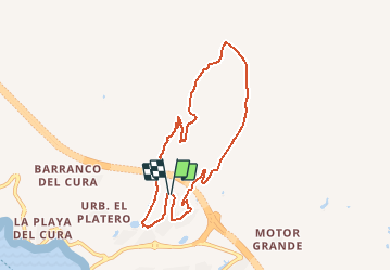
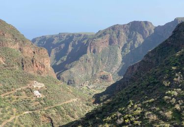
Trail Walking of 9.8 km to be discovered at Canary Islands, Las Palmas, Mogán. This trail is proposed by tonymeyer.
Description
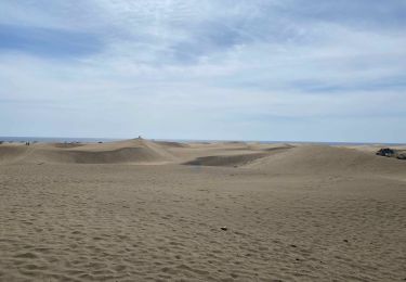
Départ au terrain de pétanque de Tauro. Descendre dans l'agglomération (la route devient une allée) puis tourner à gauche pour commencer à monter le bras droite de "l'urbanisation". La route tourne à gauche, puis à droite, puis prendre une piste en terre battue qui monte d'abord à gauche, puis à droite. suivre ce sentier qui a des cairns jusqu'à la gravière. Continuer devant en montant pour suivre les cairns jusqu'au prochain plateau (457m altitude).
Quitter le sentier pour rejoindre une piste qui traverse en tournant à gauche. Descendre le barranco jusqu'au Golf. Sortir du Golf en tournant à gauche puis reprendre la route qui monte au terrain de pétanque.
Positioning
Comments
Trails nearby
![Trail On foot San Bartolomé de Tirajana - SLCC Chira - Cruz Grande - Photo](https://media.geolcdn.com/t/375/260/3067de9c-a0e0-4d99-ac43-40c01f10e3cd.jpeg&format=jpg&maxdim=2)
![On foot On foot](https://static1.geolcdn.com/sitytour/trail-icons/100.png)
On foot
![](/images/other/stat-length.png)
![](https://static1.geolcdn.com/siteimages/upload/files/16400158638029165_repeat_loop_refresh_sync_direction_icon.png)
![Trail Walking San Bartolomé de Tirajana - Gran Canaria-San Bartolome 04-05-2017 - Photo](https://media.geolcdn.com/t/375/260/ext.jpg?maxdim=2&url=https%3A%2F%2Fstatic1.geolcdn.com%2Fsiteimages%2Fupload%2Ffiles%2F1553511878bg_sport_marche.png)
![Walking Walking](https://static1.geolcdn.com/sitytour/trail-icons/101.png)
Walking
![](/images/other/stat-length.png)
![](https://static1.geolcdn.com/siteimages/upload/files/16400158638029165_repeat_loop_refresh_sync_direction_icon.png)
![Trail Walking Tejeda - Roque Nublo (Gran Canaria) - Photo](https://media.geolcdn.com/t/375/260/1b9ffdcd-5b17-4fe3-8fab-f075c0d4fd91.jpeg&format=jpg&maxdim=2)
![Walking Walking](https://static1.geolcdn.com/sitytour/trail-icons/101.png)
Walking
![](/images/other/stat-length.png)
![](https://static1.geolcdn.com/siteimages/upload/files/16400158638029165_repeat_loop_refresh_sync_direction_icon.png)
![Trail Walking Tejeda - Pico de las Nieves (Gran Canaria) - Photo](https://media.geolcdn.com/t/375/260/8dd77f34-f9e0-4210-a8bf-aeffb88a20d1.jpeg&format=jpg&maxdim=2)
![Walking Walking](https://static1.geolcdn.com/sitytour/trail-icons/101.png)
Walking
![](/images/other/stat-length.png)
![](https://static1.geolcdn.com/siteimages/upload/files/16400158638029165_repeat_loop_refresh_sync_direction_icon.png)
![Trail Walking Ingenio - Barranco de Guayadeque (Gran Canaria) - Photo](https://media.geolcdn.com/t/375/260/0ae8eaae-9d0c-41c2-aaed-1d8d51004d0c.jpeg&format=jpg&maxdim=2)
![Walking Walking](https://static1.geolcdn.com/sitytour/trail-icons/101.png)
Walking
![](/images/other/stat-length.png)
![](https://static1.geolcdn.com/siteimages/upload/files/16400158638029165_repeat_loop_refresh_sync_direction_icon.png)
![Trail Walking San Bartolomé de Tirajana - Les dunes de Maspalomas (Gran Canaria) - Photo](https://media.geolcdn.com/t/375/260/48960093-93ab-47a7-9967-fb29d928079d.jpeg&format=jpg&maxdim=2)
![Walking Walking](https://static1.geolcdn.com/sitytour/trail-icons/101.png)
Walking
![](/images/other/stat-length.png)
![](https://static1.geolcdn.com/siteimages/upload/files/16400158638029165_repeat_loop_refresh_sync_direction_icon.png)
![Trail On foot Mogán - Circular Venguera - Photo](https://media.geolcdn.com/t/375/260/1668a46a-b3b7-4321-a883-3c8a42337dae.jpeg&format=jpg&maxdim=2)
![On foot On foot](https://static1.geolcdn.com/sitytour/trail-icons/100.png)
On foot
![](/images/other/stat-length.png)
![](https://static1.geolcdn.com/siteimages/upload/files/16400158638029165_repeat_loop_refresh_sync_direction_icon.png)
![Trail Walking San Bartolomé de Tirajana - phare de maspalomas - Photo](https://media.geolcdn.com/t/375/260/ff459a44-b678-4a4a-a9ec-994dc3492faf.jpg&format=jpg&maxdim=2)
![Walking Walking](https://static1.geolcdn.com/sitytour/trail-icons/101.png)
Walking
![](/images/other/stat-length.png)
![](https://static1.geolcdn.com/siteimages/upload/files/16400158638029165_repeat_loop_refresh_sync_direction_icon.png)
![Trail Walking Tejeda - Roque mublo - Photo](https://media.geolcdn.com/t/375/260/39fb82ac-b00e-457f-b922-27428aa1fc7c.jpg&format=jpg&maxdim=2)
![Walking Walking](https://static1.geolcdn.com/sitytour/trail-icons/101.png)
Walking
![](/images/other/stat-length.png)
![](https://static1.geolcdn.com/siteimages/upload/files/16400158638029165_repeat_loop_refresh_sync_direction_icon.png)