![](/images/other/stat-length.png)
![Trail Walking Namur - NANINNE _ Marche Fédérale _ NA _ 22/04/2023 - Photo](https://media.geolcdn.com/t/1900/400/47c73dd2-0ce0-4a41-8e57-0cfd7d1c0801.jpg&format=pjpeg&maxdim=2)
NANINNE _ Marche Fédérale _ NA _ 22/04/2023
jeangulu
User
![Length](/images/other/stat-length.png)
Length
21 km
![Max alt](https://static1.geolcdn.com/siteimages/upload/files/1508320355ic_sort_altitude_max_24dp.png)
Max alt
250 m
![Uphill gradient](https://static1.geolcdn.com/siteimages/upload/files/1508320355ic_sort_den_pos_24dp.png)
Uphill gradient
366 m
![Km-Effort](/images/other/stat-length.png)
Km-Effort
26 km
![Min alt](https://static1.geolcdn.com/siteimages/upload/files/1508320355ic_sort_altitude_min_24dp.png)
Min alt
131 m
![Downhill gradient](https://static1.geolcdn.com/siteimages/upload/files/1508320355ic_sort_den_neg_24dp.png)
Downhill gradient
367 m
![Boucle](https://static1.geolcdn.com/siteimages/upload/files/16400158638029165_repeat_loop_refresh_sync_direction_icon.png)
Boucle
Yes
Creation date :
2023-04-22 08:08:12.975
Updated on :
2023-04-22 13:17:32.331
![Walking](https://static1.geolcdn.com/sitytour/trail-icons/101.png)
5h08
Difficulty : Medium
![Scan this QR Code to open this trail in the SityTrail application](https://capi.geolives.com/qq0zvz2zws4bq2lad0pu/sitytour/trails/3631061/qr.png?size=200)
FREE GPS app for hiking
About
Trail Walking of 21 km to be discovered at Wallonia, Namur, Namur. This trail is proposed by jeangulu.
Description
Point de départ : Salle Pierre Collard _ Rue de la Gare de Naninne _ 114 _ 5100 - NANINNE.
Organisateur : WALLONIA- NAMUR a.s.b.l. Club de marche.
Carte IGN : 47/8.
La Marche des Forts
Positioning
Country:
Belgium
Region :
Wallonia
Department/Province :
Namur
Municipality :
Namur
Location:
Unknown
Start:(Dec)
Start:(UTM)
637056 ; 5587008 (31U) N.
Comments
Trails nearby
![Walking Walking](https://static1.geolcdn.com/sitytour/trail-icons/101.png)
RB-Na-20-Raccourci-2_Paysages_entre_Meuse_et_Burnot
Walking
Very difficult
(11)
Profondeville,
Wallonia,
Namur,
Belgium
![](/images/other/stat-length.png)
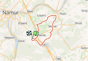
14.6 km | 22 km-effort
4h 53min
![](https://static1.geolcdn.com/siteimages/upload/files/16400158638029165_repeat_loop_refresh_sync_direction_icon.png)
Yes
![Walking Walking](https://static1.geolcdn.com/sitytour/trail-icons/101.png)
RB-Na-20-Paysages_entre_Meuse_et_Burnot
Walking
Very difficult
(16)
Profondeville,
Wallonia,
Namur,
Belgium
![](/images/other/stat-length.png)
18.5 km | 26 km-effort
5h 55min
![](https://static1.geolcdn.com/siteimages/upload/files/16400158638029165_repeat_loop_refresh_sync_direction_icon.png)
Yes
![Trail Walking Gesves - GESVES -Mozet- N°06- Biodiversité - Photo](https://media.geolcdn.com/t/375/260/ext.jpg?maxdim=2&url=https%3A%2F%2Fservices.sitytrail.com%2FGeolivesWS%2FDownloadMedia.ashx%3FTrailID%3D121400%26Media%3D865b88e1-90ed-4454-a365-7e82ed8502df.JPG)
![Walking Walking](https://static1.geolcdn.com/sitytour/trail-icons/101.png)
GESVES -Mozet- N°06- Biodiversité
Walking
Easy
(10)
Gesves,
Wallonia,
Namur,
Belgium
![](/images/other/stat-length.png)
6.3 km | 7.8 km-effort
1h 41min
![](https://static1.geolcdn.com/siteimages/upload/files/16400158638029165_repeat_loop_refresh_sync_direction_icon.png)
Yes
![Trail Walking Namur - Balade dans le bois de la Vecquée - Photo](https://media.geolcdn.com/t/375/260/ext.jpg?maxdim=2&url=https%3A%2F%2Fservices.sitytrail.com%2FGeolivesWS%2FDownloadMedia.ashx%3FTrailID%3D116970%26Media%3D93b7e593-adca-4c1d-a47c-e05bb1cf45a1.JPG)
![Walking Walking](https://static1.geolcdn.com/sitytour/trail-icons/101.png)
Balade dans le bois de la Vecquée
Walking
Medium
(6)
Namur,
Wallonia,
Namur,
Belgium
![](/images/other/stat-length.png)
13.2 km | 18.4 km-effort
3h 20min
![](https://static1.geolcdn.com/siteimages/upload/files/16400158638029165_repeat_loop_refresh_sync_direction_icon.png)
Yes
![Trail Walking Namur - Nuit du scoutisme - Namur - Photo](https://media.geolcdn.com/t/375/260/59c09917-a863-4933-801b-fff702066ffd.jpg&format=jpg&maxdim=2)
![Walking Walking](https://static1.geolcdn.com/sitytour/trail-icons/101.png)
Nuit du scoutisme - Namur
Walking
Medium
(7)
Namur,
Wallonia,
Namur,
Belgium
![](/images/other/stat-length.png)
5.5 km | 6.1 km-effort
1h 32min
![](https://static1.geolcdn.com/siteimages/upload/files/16400158638029165_repeat_loop_refresh_sync_direction_icon.png)
Yes
![Trail Walking Andenne - La Vadrouille des Castors - Photo](https://media.geolcdn.com/t/375/260/ext.jpg?maxdim=2&url=https%3A%2F%2Fservices.sitytrail.com%2FGeolivesWS%2FDownloadMedia.ashx%3FTrailID%3D272035%26Media%3D1f2a432f-27e3-4b07-a115-5648fc3f71b1.jpg)
![Walking Walking](https://static1.geolcdn.com/sitytour/trail-icons/101.png)
La Vadrouille des Castors
Walking
Easy
(5)
Andenne,
Wallonia,
Namur,
Belgium
![](/images/other/stat-length.png)
3.6 km | 4.8 km-effort
1h 0min
![](https://static1.geolcdn.com/siteimages/upload/files/16400158638029165_repeat_loop_refresh_sync_direction_icon.png)
Yes
![Trail Walking Namur - De Naninne vers Dave par les Fonds de Lustin et les Bois d'Acremont - Photo](https://media.geolcdn.com/t/375/260/ext.jpg?maxdim=2&url=https%3A%2F%2Fstatic1.geolcdn.com%2Fsiteimages%2Fupload%2Ffiles%2F1553511878bg_sport_marche.png)
![Walking Walking](https://static1.geolcdn.com/sitytour/trail-icons/101.png)
De Naninne vers Dave par les Fonds de Lustin et les Bois d'Acremont
Walking
Medium
(5)
Namur,
Wallonia,
Namur,
Belgium
![](/images/other/stat-length.png)
19 km | 25 km-effort
5h 0min
![](https://static1.geolcdn.com/siteimages/upload/files/16400158638029165_repeat_loop_refresh_sync_direction_icon.png)
Yes
![Trail Walking Profondeville - Profondeville - Photo](https://media.geolcdn.com/t/375/260/f2691757-ffd7-4f68-a5e0-1d2bff857008.jpg&format=jpg&maxdim=2)
![Walking Walking](https://static1.geolcdn.com/sitytour/trail-icons/101.png)
Profondeville
Walking
Medium
(1)
Profondeville,
Wallonia,
Namur,
Belgium
![](/images/other/stat-length.png)
16.7 km | 25 km-effort
3h 49min
![](https://static1.geolcdn.com/siteimages/upload/files/16400158638029165_repeat_loop_refresh_sync_direction_icon.png)
Yes
![Trail Walking Namur - La Plante 16 Km - Photo](https://media.geolcdn.com/t/375/260/d14bf9b4-85d7-458d-beb2-079d8e396b5c.jpeg&format=jpg&maxdim=2)
![Walking Walking](https://static1.geolcdn.com/sitytour/trail-icons/101.png)
La Plante 16 Km
Walking
Easy
(1)
Namur,
Wallonia,
Namur,
Belgium
![](/images/other/stat-length.png)
15.9 km | 21 km-effort
5h 34min
![](https://static1.geolcdn.com/siteimages/upload/files/16400158638029165_repeat_loop_refresh_sync_direction_icon.png)
Yes