


Hayman Island

David Bull
User
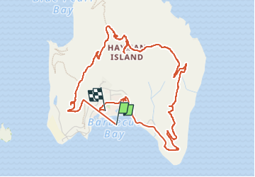

Length
8.4 km

Max alt
239 m

Uphill gradient
276 m
Km-Effort
12.1 km

Min alt
0 m

Downhill gradient
265 m
Boucle
No
Creation date :
2023-04-20 04:32:23.521
Updated on :
2023-04-20 07:03:11.318
2h29
Difficulty : Medium

FREE GPS app for hiking
 SityTrail
IGN / Geographical institutes
SityTrail World
The world is yours!
About
Trail Walking of 8.4 km to be discovered at Queensland, Whitsunday Regional. This trail is proposed by David Bull.
Description
Island loop
Positioning
Country:
Australia
Region :
Queensland
Department/Province :
Whitsunday Regional
Municipality :
Unknown
Location:
Unknown
Start:(Dec)
Start:(UTM)
697359 ; 7780927 (55K) S.
Comments
Trails nearby