![](/images/other/stat-length.png)
![Trail Walking Saint-Julien-en-Vercors - Valchevrière - Photo](https://media.geolcdn.com/t/1900/400/ext.pjpeg?maxdim=2&url=https%3A%2F%2Fstatic1.geolcdn.com%2Fsiteimages%2Fupload%2Ffiles%2F1553511878bg_sport_marche.png)
Valchevrière
hugo26
User
![Length](/images/other/stat-length.png)
Length
14.5 km
![Max alt](https://static1.geolcdn.com/siteimages/upload/files/1508320355ic_sort_altitude_max_24dp.png)
Max alt
1460 m
![Uphill gradient](https://static1.geolcdn.com/siteimages/upload/files/1508320355ic_sort_den_pos_24dp.png)
Uphill gradient
1018 m
![Km-Effort](/images/other/stat-length.png)
Km-Effort
28 km
![Min alt](https://static1.geolcdn.com/siteimages/upload/files/1508320355ic_sort_altitude_min_24dp.png)
Min alt
914 m
![Downhill gradient](https://static1.geolcdn.com/siteimages/upload/files/1508320355ic_sort_den_neg_24dp.png)
Downhill gradient
1020 m
![Boucle](https://static1.geolcdn.com/siteimages/upload/files/16400158638029165_repeat_loop_refresh_sync_direction_icon.png)
Boucle
Yes
Creation date :
2023-04-18 06:19:57.086
Updated on :
2023-04-18 06:26:06.614
![Walking](https://static1.geolcdn.com/sitytour/trail-icons/101.png)
6h23
Difficulty : Very difficult
![Scan this QR Code to open this trail in the SityTrail application](https://capi.geolives.com/qq0zvz2zws4bq2lad0pu/sitytour/trails/3625704/qr.png?size=200)
FREE GPS app for hiking
About
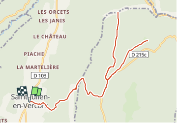
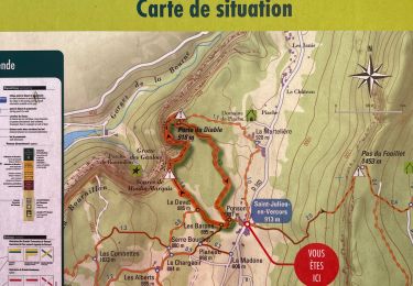
Trail Walking of 14.5 km to be discovered at Auvergne-Rhône-Alpes, Drôme, Saint-Julien-en-Vercors. This trail is proposed by hugo26.
Description
Depuis saint julien en Vercors montez aux ruines de Valchevrière puis au retour aller voir la brêche de Chalimon .Rando en aller retour.
Positioning
Country:
France
Region :
Auvergne-Rhône-Alpes
Department/Province :
Drôme
Municipality :
Saint-Julien-en-Vercors
Location:
Unknown
Start:(Dec)
Start:(UTM)
692865 ; 4991414 (31T) N.
Comments
Trails nearby
![Trail On foot Rencurel - La Balme Noire par la vire de Haute Valette - Photo](https://media.geolcdn.com/t/375/260/ext.jpg?maxdim=2&url=https%3A%2F%2Fstatic1.geolcdn.com%2Fsiteimages%2Fupload%2Ffiles%2F1545311037marcheuse_200dpi.jpg)
![On foot On foot](https://static1.geolcdn.com/sitytour/trail-icons/100.png)
La Balme Noire par la vire de Haute Valette
On foot
Difficult
(1)
Rencurel,
Auvergne-Rhône-Alpes,
Isère,
France
![](/images/other/stat-length.png)
10.5 km | 21 km-effort
Unknown
![](https://static1.geolcdn.com/siteimages/upload/files/16400158638029165_repeat_loop_refresh_sync_direction_icon.png)
Yes
![Trail Other activity Saint-Martin-en-Vercors - Cournouses pas de l'allier - Photo](https://media.geolcdn.com/t/375/260/ext.jpg?maxdim=2&url=https%3A%2F%2Fstatic1.geolcdn.com%2Fsiteimages%2Fupload%2Ffiles%2F1545311037marcheuse_200dpi.jpg)
![Other activity Other activity](https://static1.geolcdn.com/sitytour/trail-icons/900.png)
Cournouses pas de l'allier
Other activity
Medium
(1)
Saint-Martin-en-Vercors,
Auvergne-Rhône-Alpes,
Drôme,
France
![](/images/other/stat-length.png)
11 km | 21 km-effort
5h 0min
![](https://static1.geolcdn.com/siteimages/upload/files/16400158638029165_repeat_loop_refresh_sync_direction_icon.png)
Yes
![Trail Walking Choranche - La Grotte de Choranche - Photo](https://media.geolcdn.com/t/375/260/ext.jpg?maxdim=2&url=https%3A%2F%2Fstatic1.geolcdn.com%2Fsiteimages%2Fupload%2Ffiles%2F1553511878bg_sport_marche.png)
![Walking Walking](https://static1.geolcdn.com/sitytour/trail-icons/101.png)
La Grotte de Choranche
Walking
Difficult
(1)
Choranche,
Auvergne-Rhône-Alpes,
Isère,
France
![](/images/other/stat-length.png)
17.8 km | 33 km-effort
7h 6min
![](https://static1.geolcdn.com/siteimages/upload/files/16400158638029165_repeat_loop_refresh_sync_direction_icon.png)
Yes
![Trail Walking Presles - la Balme Riendre - Photo](https://media.geolcdn.com/t/375/260/ext.jpg?maxdim=2&url=https%3A%2F%2Fmedia.geolcdn.com%2Ff%2F08ad1426-8258-4d3d-9efa-c77b826ebb7c.jpg)
![Walking Walking](https://static1.geolcdn.com/sitytour/trail-icons/101.png)
la Balme Riendre
Walking
Medium
Presles,
Auvergne-Rhône-Alpes,
Isère,
France
![](/images/other/stat-length.png)
7.1 km | 11.4 km-effort
2h 5min
![](https://static1.geolcdn.com/siteimages/upload/files/16400158638029165_repeat_loop_refresh_sync_direction_icon.png)
No
![Trail Walking Choranche - reco tunnel Arbois - Photo](https://media.geolcdn.com/t/375/260/ext.jpg?maxdim=2&url=https%3A%2F%2Fmedia.geolcdn.com%2Ff%2F6e493fa5-48dc-4708-85a1-41ae650a4aac.jpg)
![Walking Walking](https://static1.geolcdn.com/sitytour/trail-icons/101.png)
reco tunnel Arbois
Walking
Medium
Choranche,
Auvergne-Rhône-Alpes,
Isère,
France
![](/images/other/stat-length.png)
4.4 km | 8.8 km-effort
1h 54min
![](https://static1.geolcdn.com/siteimages/upload/files/16400158638029165_repeat_loop_refresh_sync_direction_icon.png)
Yes
![Trail Walking Rencurel - 38 vire bourne goule noire - Photo](https://media.geolcdn.com/t/375/260/ext.jpg?maxdim=2&url=https%3A%2F%2Fmedia.geolcdn.com%2Ff%2F62b6a30b-af4a-4e09-9d99-ed85f47fb4ae.jpg)
![Walking Walking](https://static1.geolcdn.com/sitytour/trail-icons/101.png)
38 vire bourne goule noire
Walking
Medium
Rencurel,
Auvergne-Rhône-Alpes,
Isère,
France
![](/images/other/stat-length.png)
11.9 km | 24 km-effort
6h 44min
![](https://static1.geolcdn.com/siteimages/upload/files/16400158638029165_repeat_loop_refresh_sync_direction_icon.png)
Yes
![Trail Walking Saint-Martin-en-Vercors - La Sambue et le belvedere de Chateau Julien - Photo](https://media.geolcdn.com/t/375/260/ext.jpg?maxdim=2&url=https%3A%2F%2Fmedia.geolcdn.com%2Ff%2F72b8b951-6e8a-477e-b604-67d7f42508d9.jpg)
![Walking Walking](https://static1.geolcdn.com/sitytour/trail-icons/101.png)
La Sambue et le belvedere de Chateau Julien
Walking
Very difficult
Saint-Martin-en-Vercors,
Auvergne-Rhône-Alpes,
Drôme,
France
![](/images/other/stat-length.png)
15.7 km | 24 km-effort
5h 27min
![](https://static1.geolcdn.com/siteimages/upload/files/16400158638029165_repeat_loop_refresh_sync_direction_icon.png)
Yes
![Trail Walking Saint-Martin-en-Vercors - Pas st Martin - Photo](https://media.geolcdn.com/t/375/260/ext.jpg?maxdim=2&url=https%3A%2F%2Fmedia.geolcdn.com%2Ff%2Feec31db7-0b0a-433a-a520-6069113e445d.jpg)
![Walking Walking](https://static1.geolcdn.com/sitytour/trail-icons/101.png)
Pas st Martin
Walking
Very easy
Saint-Martin-en-Vercors,
Auvergne-Rhône-Alpes,
Drôme,
France
![](/images/other/stat-length.png)
4.9 km | 6.9 km-effort
2h 34min
![](https://static1.geolcdn.com/siteimages/upload/files/16400158638029165_repeat_loop_refresh_sync_direction_icon.png)
Yes
![Trail Walking Rencurel - Pas de la Chêvre pas des rages vire de la Ferrière - Photo](https://media.geolcdn.com/t/375/260/ext.jpg?maxdim=2&url=https%3A%2F%2Fmedia.geolcdn.com%2Ff%2Fcf615a20-ce70-42ae-bd66-563a4135e704.jpg)
![Walking Walking](https://static1.geolcdn.com/sitytour/trail-icons/101.png)
Pas de la Chêvre pas des rages vire de la Ferrière
Walking
Very difficult
Rencurel,
Auvergne-Rhône-Alpes,
Isère,
France
![](/images/other/stat-length.png)
21 km | 37 km-effort
8h 23min
![](https://static1.geolcdn.com/siteimages/upload/files/16400158638029165_repeat_loop_refresh_sync_direction_icon.png)
Yes