![](/images/other/stat-length.png)
![Trail Walking Caussols - Sommet de Calern + Bories-17-04-23 - Photo](https://media.geolcdn.com/t/1900/400/3dc9997f-0b30-478a-9e7b-62a115fa8b92.jpg&format=pjpeg&maxdim=2)
Sommet de Calern + Bories-17-04-23
Christiancordin
User
![Length](/images/other/stat-length.png)
Length
14.2 km
![Max alt](https://static1.geolcdn.com/siteimages/upload/files/1508320355ic_sort_altitude_max_24dp.png)
Max alt
1452 m
![Uphill gradient](https://static1.geolcdn.com/siteimages/upload/files/1508320355ic_sort_den_pos_24dp.png)
Uphill gradient
449 m
![Km-Effort](/images/other/stat-length.png)
Km-Effort
20 km
![Min alt](https://static1.geolcdn.com/siteimages/upload/files/1508320355ic_sort_altitude_min_24dp.png)
Min alt
1100 m
![Downhill gradient](https://static1.geolcdn.com/siteimages/upload/files/1508320355ic_sort_den_neg_24dp.png)
Downhill gradient
448 m
![Boucle](https://static1.geolcdn.com/siteimages/upload/files/16400158638029165_repeat_loop_refresh_sync_direction_icon.png)
Boucle
Yes
Creation date :
2023-04-17 08:09:50.427
Updated on :
2023-04-22 16:51:35.915
![Walking](https://static1.geolcdn.com/sitytour/trail-icons/101.png)
3h42
Difficulty : Medium
![Scan this QR Code to open this trail in the SityTrail application](https://capi.geolives.com/qq0zvz2zws4bq2lad0pu/sitytour/trails/3624885/qr.png?size=200)
FREE GPS app for hiking
About
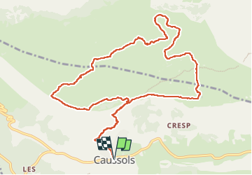
Trail Walking of 14.2 km to be discovered at Provence-Alpes-Côte d'Azur, Maritime Alps, Caussols. This trail is proposed by Christiancordin.
Description
PK mairie de Caussols-ND de Calern-sommet de Calern 1458m-les Baumes-les bories-les dolines-observatoire de la Côte-d'Azur.
Positioning
Country:
France
Region :
Provence-Alpes-Côte d'Azur
Department/Province :
Maritime Alps
Municipality :
Caussols
Location:
Unknown
Start:(Dec)
Start:(UTM)
330912 ; 4845292 (32T) N.
Comments
Trails nearby
![Trail Walking Caussols - Traversée du Gros Pounch 1270 m, depuis le Col de la Sine - Photo](https://media.geolcdn.com/t/375/260/ext.jpg?maxdim=2&url=https%3A%2F%2Fservices.sitytrail.com%2FGeolivesWS%2FDownloadMedia.ashx%3FTrailID%3D317964%26Media%3D17404_1.jpg)
![Walking Walking](https://static1.geolcdn.com/sitytour/trail-icons/101.png)
Traversée du Gros Pounch 1270 m, depuis le Col de la Sine
Walking
Easy
(2)
Caussols,
Provence-Alpes-Côte d'Azur,
Maritime Alps,
France
![](/images/other/stat-length.png)
14.7 km | 19.9 km-effort
4h 15min
![](https://static1.geolcdn.com/siteimages/upload/files/16400158638029165_repeat_loop_refresh_sync_direction_icon.png)
Yes
![Trail Walking Caussols - Le Haut Montet 1335m, Plateau de Caussols - Photo](https://media.geolcdn.com/t/375/260/ext.jpg?maxdim=2&url=https%3A%2F%2Fservices.sitytrail.com%2FGeolivesWS%2FDownloadMedia.ashx%3FTrailID%3D214865%26Media%3D15407_1.jpg)
![Walking Walking](https://static1.geolcdn.com/sitytour/trail-icons/101.png)
Le Haut Montet 1335m, Plateau de Caussols
Walking
Easy
(1)
Caussols,
Provence-Alpes-Côte d'Azur,
Maritime Alps,
France
![](/images/other/stat-length.png)
13.5 km | 18.6 km-effort
4h 0min
![](https://static1.geolcdn.com/siteimages/upload/files/16400158638029165_repeat_loop_refresh_sync_direction_icon.png)
Yes
![Trail Walking Andon - Canaux Audibergue Montagne de Thiey depuis Canaux trace réelle - Photo](https://media.geolcdn.com/t/375/260/051e1c19-173e-486c-8510-4484d711db7f.jpg&format=jpg&maxdim=2)
![Walking Walking](https://static1.geolcdn.com/sitytour/trail-icons/101.png)
Canaux Audibergue Montagne de Thiey depuis Canaux trace réelle
Walking
Very difficult
Andon,
Provence-Alpes-Côte d'Azur,
Maritime Alps,
France
![](/images/other/stat-length.png)
20 km | 33 km-effort
7h 23min
![](https://static1.geolcdn.com/siteimages/upload/files/16400158638029165_repeat_loop_refresh_sync_direction_icon.png)
Yes
![Trail Walking Cipières - Cipières Sommet de Calern - Grotte de ND de Calern - Photo](https://media.geolcdn.com/t/375/260/dcc22407-202f-49e5-a220-25d384f38a74.jpg&format=jpg&maxdim=2)
![Walking Walking](https://static1.geolcdn.com/sitytour/trail-icons/101.png)
Cipières Sommet de Calern - Grotte de ND de Calern
Walking
Very difficult
Cipières,
Provence-Alpes-Côte d'Azur,
Maritime Alps,
France
![](/images/other/stat-length.png)
21 km | 31 km-effort
7h 20min
![](https://static1.geolcdn.com/siteimages/upload/files/16400158638029165_repeat_loop_refresh_sync_direction_icon.png)
No
![Trail Walking Saint-Vallier-de-Thiey - canau - Photo](https://media.geolcdn.com/t/375/260/ca899ab5-eb13-42e5-a84d-3c58455096f9.jpg&format=jpg&maxdim=2)
![Walking Walking](https://static1.geolcdn.com/sitytour/trail-icons/101.png)
canau
Walking
Very difficult
Saint-Vallier-de-Thiey,
Provence-Alpes-Côte d'Azur,
Maritime Alps,
France
![](/images/other/stat-length.png)
15.3 km | 23 km-effort
6h 33min
![](https://static1.geolcdn.com/siteimages/upload/files/16400158638029165_repeat_loop_refresh_sync_direction_icon.png)
Yes
![Trail Walking Le Bar-sur-Loup - rando - Photo](https://media.geolcdn.com/t/375/260/fa0ef731-2bd1-40ee-a714-99f05472c6fe.jpg&format=jpg&maxdim=2)
![Walking Walking](https://static1.geolcdn.com/sitytour/trail-icons/101.png)
rando
Walking
Very difficult
Le Bar-sur-Loup,
Provence-Alpes-Côte d'Azur,
Maritime Alps,
France
![](/images/other/stat-length.png)
12.1 km | 21 km-effort
6h 9min
![](https://static1.geolcdn.com/siteimages/upload/files/16400158638029165_repeat_loop_refresh_sync_direction_icon.png)
No
![Trail On foot Caussols - Plateau de Caussols - Photo](https://media.geolcdn.com/t/375/260/598f9742-6bcf-489a-8a9a-6409dd2e2888.jpeg&format=jpg&maxdim=2)
![On foot On foot](https://static1.geolcdn.com/sitytour/trail-icons/100.png)
Plateau de Caussols
On foot
Easy
Caussols,
Provence-Alpes-Côte d'Azur,
Maritime Alps,
France
![](/images/other/stat-length.png)
13.9 km | 19.1 km-effort
4h 20min
![](https://static1.geolcdn.com/siteimages/upload/files/16400158638029165_repeat_loop_refresh_sync_direction_icon.png)
Yes
![Trail On foot Cipières - Traversée de l'Estéron - Etape 2 - Photo](https://media.geolcdn.com/t/375/260/ebd4d990-1504-43f1-96fb-3c8749b403dd.jpeg&format=jpg&maxdim=2)
![On foot On foot](https://static1.geolcdn.com/sitytour/trail-icons/100.png)
Traversée de l'Estéron - Etape 2
On foot
Difficult
Cipières,
Provence-Alpes-Côte d'Azur,
Maritime Alps,
France
![](/images/other/stat-length.png)
21 km | 41 km-effort
9h 18min
![](https://static1.geolcdn.com/siteimages/upload/files/16400158638029165_repeat_loop_refresh_sync_direction_icon.png)
No
![Trail On foot Cipières - Traversée de l'Estéron - Etape 1 - Photo](https://media.geolcdn.com/t/375/260/0e49d622-3c08-45d7-a080-59d63fc9110b.jpeg&format=jpg&maxdim=2)
![On foot On foot](https://static1.geolcdn.com/sitytour/trail-icons/100.png)
Traversée de l'Estéron - Etape 1
On foot
Medium
Cipières,
Provence-Alpes-Côte d'Azur,
Maritime Alps,
France
![](/images/other/stat-length.png)
18.4 km | 29 km-effort
6h 28min
![](https://static1.geolcdn.com/siteimages/upload/files/16400158638029165_repeat_loop_refresh_sync_direction_icon.png)
No