Trail Walking Saint-Guiraud - Rabieux canyon rocher des vierges - Photo

Rabieux canyon rocher des vierges

 grageot
grageot

User

© OpenStreetMap contributors
Length
Length
19.2 km
Max alt
Max alt
522 m
Uphill gradient
Uphill gradient
732 m
Km-Effort
Km-Effort  
29 km
Min alt
Min alt
80 m
Downhill gradient
Downhill gradient
729 m
Boucle
Boucle
Yes
Creation date :
2014-12-10 00:00:00.0
Updated on :
2014-12-10 00:00:00.0

(0 Reviews)

Walking
Walking
7h34
Difficulty : Difficult

Scan this QR Code to open this trail in the SityTrail application

FREE GPS app for hiking

Logo SityTrail SityTrail

IGN / Geographical institutes

Download SityTrail from the App Store Download SityTrail from Google Play

Logo SityTrail SityTrail World

The world is yours!

Download SityTrail from the App Store Download SityTrail from Google Play Download SityTrail on Huawei AppGallery

About

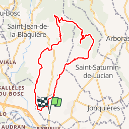
Trail Walking of 19.2 km to be discovered at Occitania, Hérault, Saint-Guiraud. This trail is proposed by grageot.

Description

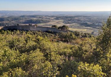
sportive dans le canyon,bartasse  après les rochers des vierges suivre le GR 653 plutôt que la crête

Elevation profile

Points of interest

Point of interest Saint-Saturnin-de-Lucian - prendre le GR 653 - Photo
grageot
SAINT-SATURNIN-DE-LUCIAN 
Point of interest Saint-Saturnin-de-Lucian - sortie canyon - Photo
grageot
SAINT-SATURNIN-DE-LUCIAN 
Point of interest Le Bosc - montée à la Grèbe - Photo
grageot
Point of interest Saint-Guiraud - progression dans le canyon - Photo
grageot
Point of interest Saint-Jean-de-la-Blaquière - Arrivée du GR 653 - Photo
grageot
SAINT-JEAN-DE-LA-BLAQUIÈRE 
Point of interest Saint-Guiraud - parking - Photo
grageot
SAINT-GUIRAUD 
Point of interest Saint-Jean-de-la-Blaquière - suivre le GR653 - Photo
grageot
SAINT-JEAN-DE-LA-BLAQUIÈRE 

Positioning

Country:
France
Region :
Occitania
Department/Province :
Hérault
Municipality :
Saint-Guiraud
Location:
Unknown
Start:(UTM)
535363 ; 4835747 (31T) N.

Trails nearby

Trail Walking Le Bosc - Saint-Alban - Célis - La Roque  - Photo
Walking
mdauzat

Walking

Medium
(1)
Le Bosc, Occitania, Hérault, France
5.7 km | 7.9 km-effort
1h 47min
Yes
Trail Walking Saint-Saturnin-de-Lucian - Le Rocher des vierges - Photo
Walking
daniel34

Walking

Medium
(2)
Saint-Saturnin-de-Lucian, Occitania, Hérault, France
12.1 km | 17.4 km-effort
5h 1min
Yes
Trail Walking Le Bosc - Le Bosc - prieuré de Grandmont - Le Brédou - Soumont - Photo
Walking
vertygo

Walking

Medium
(2)
Le Bosc, Occitania, Hérault, France
19.1 km | 28 km-effort
5h 46min
Yes
Trail Walking Lacoste - lacoste vers le lac - Photo
Walking
kiki34

Walking

Medium
(2)
Lacoste, Occitania, Hérault, France
12.2 km | 15.4 km-effort
3h 11min
Yes
Trail Mountain bike Clermont-l'Hérault - Espace VTT FFC Salagou - Circuit n° 2 - Les Balcons du Salagou - Photo
Mountain bike
tracegps

Mountain bike

Medium
(1)
Clermont-l'Hérault, Occitania, Hérault, France
12.3 km | 15.6 km-effort
1h 10min
Yes
Trail Mountain bike Clermont-l'Hérault - Espace VTT FFC Salagou - Circuit n° 1 - Le Lac du Salagou - Photo
Mountain bike
tracegps

Mountain bike

Difficult
(4)
Clermont-l'Hérault, Occitania, Hérault, France
27 km | 32 km-effort
2h 0min
Yes
Trail Walking Saint-Jean-de-la-Blaquière - Les Bois de Homs et de Latude - Photo
Walking
gerardhenr

Walking

Easy
(1)
Saint-Jean-de-la-Blaquière, Occitania, Hérault, France
9.3 km | 13.1 km-effort
2h 27min
Yes
Trail Walking Clermont-l'Hérault - les vailhes - Photo
Walking
dpop34

Walking

Very easy
(1)
Clermont-l'Hérault, Occitania, Hérault, France
15.2 km | 20 km-effort
3h 17min
Yes
Trail Walking Montpeyroux - Le Castellas de Montpeyroux - Photo
Walking
Indi34

Walking

Medium
Montpeyroux, Occitania, Hérault, France
6.6 km | 9.5 km-effort
2h 2min
Yes


Close
My subscriptions