![](/images/other/stat-length.png)
![Trail Walking La Chapelle-Gonaguet - La Chapelle-Gonaguet Brunies 10km - Photo](https://media.geolcdn.com/t/1900/400/ext.pjpeg?maxdim=2&url=https%3A%2F%2Fstatic1.geolcdn.com%2Fsiteimages%2Fupload%2Ffiles%2F1553511878bg_sport_marche.png)
La Chapelle-Gonaguet Brunies 10km
YV24
User
![Length](/images/other/stat-length.png)
Length
9.8 km
![Max alt](https://static1.geolcdn.com/siteimages/upload/files/1508320355ic_sort_altitude_max_24dp.png)
Max alt
199 m
![Uphill gradient](https://static1.geolcdn.com/siteimages/upload/files/1508320355ic_sort_den_pos_24dp.png)
Uphill gradient
177 m
![Km-Effort](/images/other/stat-length.png)
Km-Effort
12.2 km
![Min alt](https://static1.geolcdn.com/siteimages/upload/files/1508320355ic_sort_altitude_min_24dp.png)
Min alt
121 m
![Downhill gradient](https://static1.geolcdn.com/siteimages/upload/files/1508320355ic_sort_den_neg_24dp.png)
Downhill gradient
177 m
![Boucle](https://static1.geolcdn.com/siteimages/upload/files/16400158638029165_repeat_loop_refresh_sync_direction_icon.png)
Boucle
Yes
Creation date :
2014-12-10 00:00:00.0
Updated on :
2014-12-10 00:00:00.0
![Walking](https://static1.geolcdn.com/sitytour/trail-icons/101.png)
2h42
Difficulty : Easy
![Scan this QR Code to open this trail in the SityTrail application](https://capi.geolives.com/qq0zvz2zws4bq2lad0pu/sitytour/trails/362011/qr.png?size=200)
FREE GPS app for hiking
About
Trail Walking of 9.8 km to be discovered at New Aquitaine, Dordogne, La Chapelle-Gonaguet. This trail is proposed by YV24.
Description
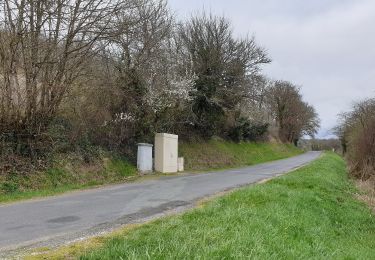
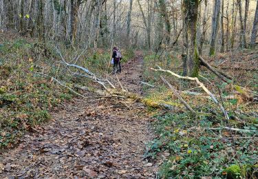
Selon PDIPR n°21 carte Communauté Agglomération Périgueux. Rando variée, un peu de petits reliefs. ATTENTION novembre 2014 balisage perfectible : qqfois confus, induisant en erreur, absent, ... Praticable en tout temps.
Positioning
Country:
France
Region :
New Aquitaine
Department/Province :
Dordogne
Municipality :
La Chapelle-Gonaguet
Location:
Unknown
Start:(Dec)
Start:(UTM)
312563 ; 5011283 (31T) N.
Comments
Trails nearby
![Trail On foot Bussac - Boucle de Bussac - Photo](https://media.geolcdn.com/t/375/260/5fccc024-9483-4e9e-aafa-fb24ea2402de.jpeg&format=jpg&maxdim=2)
![On foot On foot](https://static1.geolcdn.com/sitytour/trail-icons/100.png)
Boucle de Bussac
On foot
Easy
Bussac,
New Aquitaine,
Dordogne,
France
![](/images/other/stat-length.png)
3.7 km | 4.8 km-effort
1h 5min
![](https://static1.geolcdn.com/siteimages/upload/files/16400158638029165_repeat_loop_refresh_sync_direction_icon.png)
Yes
![Trail Walking La Chapelle-Gonaguet - La Chapelle Gonaguet 9 km - Photo](https://media.geolcdn.com/t/375/260/2419184c-9d78-41af-8bf7-802b3e84ff48.jpg&format=jpg&maxdim=2)
![Walking Walking](https://static1.geolcdn.com/sitytour/trail-icons/101.png)
La Chapelle Gonaguet 9 km
Walking
Medium
La Chapelle-Gonaguet,
New Aquitaine,
Dordogne,
France
![](/images/other/stat-length.png)
9 km | 10.7 km-effort
2h 26min
![](https://static1.geolcdn.com/siteimages/upload/files/16400158638029165_repeat_loop_refresh_sync_direction_icon.png)
Yes
![Trail Walking Chancelade - Circuit de l'Abbaye de Chancelade - Photo](https://media.geolcdn.com/t/375/260/16bcd257-155c-4b42-a479-9684c98ab4d4.jpg&format=jpg&maxdim=2)
![Walking Walking](https://static1.geolcdn.com/sitytour/trail-icons/101.png)
Circuit de l'Abbaye de Chancelade
Walking
Difficult
Chancelade,
New Aquitaine,
Dordogne,
France
![](/images/other/stat-length.png)
12.8 km | 18.3 km-effort
4h 9min
![](https://static1.geolcdn.com/siteimages/upload/files/16400158638029165_repeat_loop_refresh_sync_direction_icon.png)
Yes
![Trail Walking Chancelade - Boucle des Andrivaux - Photo](https://media.geolcdn.com/t/375/260/3a7f865a-dc4d-41a4-a258-9294003c8232.jpg&format=jpg&maxdim=2)
![Walking Walking](https://static1.geolcdn.com/sitytour/trail-icons/101.png)
Boucle des Andrivaux
Walking
Very difficult
Chancelade,
New Aquitaine,
Dordogne,
France
![](/images/other/stat-length.png)
14.8 km | 19.3 km-effort
4h 23min
![](https://static1.geolcdn.com/siteimages/upload/files/16400158638029165_repeat_loop_refresh_sync_direction_icon.png)
Yes
![Trail Walking Chancelade - Boucle de la Terrassonnie - Photo](https://media.geolcdn.com/t/375/260/ext.jpg?maxdim=2&url=https%3A%2F%2Fservices.sitytrail.com%2FGeolivesWS%2FDownloadMedia.ashx%3FTrailID%3D1093073%26Media%3Dfix__20190106115620.jpg)
![Walking Walking](https://static1.geolcdn.com/sitytour/trail-icons/101.png)
Boucle de la Terrassonnie
Walking
Easy
Chancelade,
New Aquitaine,
Dordogne,
France
![](/images/other/stat-length.png)
11.2 km | 14.7 km-effort
3h 37min
![](https://static1.geolcdn.com/siteimages/upload/files/16400158638029165_repeat_loop_refresh_sync_direction_icon.png)
Yes
![Trail Walking Mensignac - randogps24-658 - Photo](https://media.geolcdn.com/t/375/260/ext.jpg?maxdim=2&url=https%3A%2F%2Fstatic1.geolcdn.com%2Fsiteimages%2Fupload%2Ffiles%2F1553511878bg_sport_marche.png)
![Walking Walking](https://static1.geolcdn.com/sitytour/trail-icons/101.png)
randogps24-658
Walking
Difficult
Mensignac,
New Aquitaine,
Dordogne,
France
![](/images/other/stat-length.png)
12.4 km | 15.7 km-effort
3h 33min
![](https://static1.geolcdn.com/siteimages/upload/files/16400158638029165_repeat_loop_refresh_sync_direction_icon.png)
Yes
![Trail Walking Marsac-sur-l'Isle - Marsac - Photo](https://media.geolcdn.com/t/375/260/ext.jpg?maxdim=2&url=https%3A%2F%2Fstatic1.geolcdn.com%2Fsiteimages%2Fupload%2Ffiles%2F1553511878bg_sport_marche.png)
![Walking Walking](https://static1.geolcdn.com/sitytour/trail-icons/101.png)
Marsac
Walking
Easy
Marsac-sur-l'Isle,
New Aquitaine,
Dordogne,
France
![](/images/other/stat-length.png)
9.2 km | 11 km-effort
2h 29min
![](https://static1.geolcdn.com/siteimages/upload/files/16400158638029165_repeat_loop_refresh_sync_direction_icon.png)
Yes
![Trail Walking Annesse-et-Beaulieu - Boucle gare de Beaulieu - Photo](https://media.geolcdn.com/t/375/260/c3112417-d636-4aee-9cea-765d1675244f.jpg&format=jpg&maxdim=2)
![Walking Walking](https://static1.geolcdn.com/sitytour/trail-icons/101.png)
Boucle gare de Beaulieu
Walking
Difficult
Annesse-et-Beaulieu,
New Aquitaine,
Dordogne,
France
![](/images/other/stat-length.png)
13.9 km | 17.5 km-effort
3h 58min
![](https://static1.geolcdn.com/siteimages/upload/files/16400158638029165_repeat_loop_refresh_sync_direction_icon.png)
Yes
![Trail Walking Chancelade - Chancelade - Photo](https://media.geolcdn.com/t/375/260/f516afca-a53a-45cf-8602-c47268c2e555.jpg&format=jpg&maxdim=2)
![Walking Walking](https://static1.geolcdn.com/sitytour/trail-icons/101.png)
Chancelade
Walking
Difficult
Chancelade,
New Aquitaine,
Dordogne,
France
![](/images/other/stat-length.png)
13.7 km | 18.4 km-effort
4h 11min
![](https://static1.geolcdn.com/siteimages/upload/files/16400158638029165_repeat_loop_refresh_sync_direction_icon.png)
Yes