![](/images/other/stat-length.png)
![Trail Walking Écrouves - Ecrouves - Photo](https://media.geolcdn.com/t/1900/400/ext.pjpeg?maxdim=2&url=https%3A%2F%2Fstatic1.geolcdn.com%2Fsiteimages%2Fupload%2Ffiles%2F1553511878bg_sport_marche.png)
Ecrouves
DanielROLLET
User
![Length](/images/other/stat-length.png)
Length
12.1 km
![Max alt](https://static1.geolcdn.com/siteimages/upload/files/1508320355ic_sort_altitude_max_24dp.png)
Max alt
382 m
![Uphill gradient](https://static1.geolcdn.com/siteimages/upload/files/1508320355ic_sort_den_pos_24dp.png)
Uphill gradient
283 m
![Km-Effort](/images/other/stat-length.png)
Km-Effort
15.9 km
![Min alt](https://static1.geolcdn.com/siteimages/upload/files/1508320355ic_sort_altitude_min_24dp.png)
Min alt
262 m
![Downhill gradient](https://static1.geolcdn.com/siteimages/upload/files/1508320355ic_sort_den_neg_24dp.png)
Downhill gradient
284 m
![Boucle](https://static1.geolcdn.com/siteimages/upload/files/16400158638029165_repeat_loop_refresh_sync_direction_icon.png)
Boucle
Yes
Creation date :
2016-12-28 00:00:00.0
Updated on :
2016-12-28 00:00:00.0
![Walking](https://static1.geolcdn.com/sitytour/trail-icons/101.png)
3h23
Difficulty : Easy
![Scan this QR Code to open this trail in the SityTrail application](https://capi.geolives.com/qq0zvz2zws4bq2lad0pu/sitytour/trails/361844/qr.png?size=200)
FREE GPS app for hiking
About
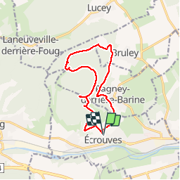
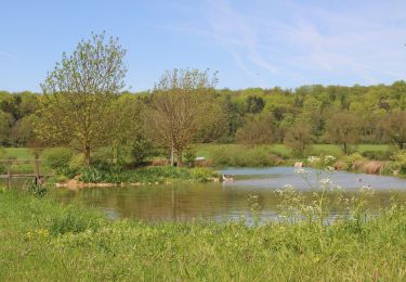
Trail Walking of 12.1 km to be discovered at Grand Est, Meurthe-et-Moselle, Écrouves. This trail is proposed by DanielROLLET.
Description
11.11.2014
Départ et retour à l'église d'Ecrouves.
Boucle par le fort de Lucey, le Val des Nonnes, Bruley et Pagney derrière Barine
Positioning
Country:
France
Region :
Grand Est
Department/Province :
Meurthe-et-Moselle
Municipality :
Écrouves
Location:
Unknown
Start:(Dec)
Start:(UTM)
709061 ; 5395889 (31U) N.
Comments
Trails nearby
![Trail On foot Bruley - Circuit de la Petite Linotte - Photo](https://media.geolcdn.com/t/375/260/c8d38300-38c0-4b90-af2c-ff730d2ffb15.jpeg&format=jpg&maxdim=2)
![On foot On foot](https://static1.geolcdn.com/sitytour/trail-icons/100.png)
Circuit de la Petite Linotte
On foot
Easy
Bruley,
Grand Est,
Meurthe-et-Moselle,
France
![](/images/other/stat-length.png)
9.2 km | 12 km-effort
2h 43min
![](https://static1.geolcdn.com/siteimages/upload/files/16400158638029165_repeat_loop_refresh_sync_direction_icon.png)
No
![Trail Mountain bike Toul - Côtes de Toul 50k 2012 - Photo](https://media.geolcdn.com/t/375/260/ext.jpg?maxdim=2&url=https%3A%2F%2Fstatic1.geolcdn.com%2Fsiteimages%2Fupload%2Ffiles%2F1524743154velo.jpg)
![Mountain bike Mountain bike](https://static1.geolcdn.com/sitytour/trail-icons/202.png)
Côtes de Toul 50k 2012
Mountain bike
Difficult
(2)
Toul,
Grand Est,
Meurthe-et-Moselle,
France
![](/images/other/stat-length.png)
59 km | 75 km-effort
5h 15min
![](https://static1.geolcdn.com/siteimages/upload/files/16400158638029165_repeat_loop_refresh_sync_direction_icon.png)
Yes
![Trail Mountain bike Écrouves - 1 ère rando VTT - Photo](https://media.geolcdn.com/t/375/260/ext.jpg?maxdim=2&url=https%3A%2F%2Fstatic1.geolcdn.com%2Fsiteimages%2Fupload%2Ffiles%2F1524743154velo.jpg)
![Mountain bike Mountain bike](https://static1.geolcdn.com/sitytour/trail-icons/202.png)
1 ère rando VTT
Mountain bike
Very easy
(1)
Écrouves,
Grand Est,
Meurthe-et-Moselle,
France
![](/images/other/stat-length.png)
7.5 km | 9.5 km-effort
Unknown
![](https://static1.geolcdn.com/siteimages/upload/files/16400158638029165_repeat_loop_refresh_sync_direction_icon.png)
Yes
![Trail On foot Laneuveville-derrière-Foug - Circuit de Domfontaine - Photo](https://media.geolcdn.com/t/375/260/93f65dee-64e5-4ca3-9bc3-5701a8dbad57.jpeg&format=jpg&maxdim=2)
![On foot On foot](https://static1.geolcdn.com/sitytour/trail-icons/100.png)
Circuit de Domfontaine
On foot
Easy
Laneuveville-derrière-Foug,
Grand Est,
Meurthe-et-Moselle,
France
![](/images/other/stat-length.png)
9.5 km | 12.6 km-effort
2h 51min
![](https://static1.geolcdn.com/siteimages/upload/files/16400158638029165_repeat_loop_refresh_sync_direction_icon.png)
Yes
![Trail On foot Trondes - Circuit du Romont - Photo](https://media.geolcdn.com/t/375/260/07a99b10-d59a-4513-b094-c282117c9672.jpeg&format=jpg&maxdim=2)
![On foot On foot](https://static1.geolcdn.com/sitytour/trail-icons/100.png)
Circuit du Romont
On foot
Easy
Trondes,
Grand Est,
Meurthe-et-Moselle,
France
![](/images/other/stat-length.png)
6.8 km | 8.1 km-effort
1h 50min
![](https://static1.geolcdn.com/siteimages/upload/files/16400158638029165_repeat_loop_refresh_sync_direction_icon.png)
Yes
![Trail On foot Foug - Circuit de Grammont - Photo](https://media.geolcdn.com/t/375/260/d7a9625f-1b4f-4d64-86f5-7a590416d8ca.jpeg&format=jpg&maxdim=2)
![On foot On foot](https://static1.geolcdn.com/sitytour/trail-icons/100.png)
Circuit de Grammont
On foot
Easy
Foug,
Grand Est,
Meurthe-et-Moselle,
France
![](/images/other/stat-length.png)
15.6 km | 19.3 km-effort
4h 23min
![](https://static1.geolcdn.com/siteimages/upload/files/16400158638029165_repeat_loop_refresh_sync_direction_icon.png)
No
![Trail On foot Choloy-Ménillot - Boucle des Sources - Photo](https://media.geolcdn.com/t/375/260/ac86fb3f-3e84-4c34-b460-6a4b9dab63b7.jpeg&format=jpg&maxdim=2)
![On foot On foot](https://static1.geolcdn.com/sitytour/trail-icons/100.png)
Boucle des Sources
On foot
Easy
Choloy-Ménillot,
Grand Est,
Meurthe-et-Moselle,
France
![](/images/other/stat-length.png)
10.4 km | 11.9 km-effort
2h 42min
![](https://static1.geolcdn.com/siteimages/upload/files/16400158638029165_repeat_loop_refresh_sync_direction_icon.png)
No
![Trail On foot Lucey - Circuit des Vignes - Photo](https://media.geolcdn.com/t/375/260/e81c5232-ac1b-4f67-955e-d25a321053a6.jpeg&format=jpg&maxdim=2)
![On foot On foot](https://static1.geolcdn.com/sitytour/trail-icons/100.png)
Circuit des Vignes
On foot
Easy
Lucey,
Grand Est,
Meurthe-et-Moselle,
France
![](/images/other/stat-length.png)
4.2 km | 5.2 km-effort
1h 11min
![](https://static1.geolcdn.com/siteimages/upload/files/16400158638029165_repeat_loop_refresh_sync_direction_icon.png)
Yes
![Trail On foot Laneuveville-derrière-Foug - Circuit du Point du Jour - Photo](https://media.geolcdn.com/t/375/260/b1cded44-ffa4-4904-97ef-f463ee03586b.jpeg&format=jpg&maxdim=2)
![On foot On foot](https://static1.geolcdn.com/sitytour/trail-icons/100.png)
Circuit du Point du Jour
On foot
Easy
Laneuveville-derrière-Foug,
Grand Est,
Meurthe-et-Moselle,
France
![](/images/other/stat-length.png)
6.8 km | 8 km-effort
1h 49min
![](https://static1.geolcdn.com/siteimages/upload/files/16400158638029165_repeat_loop_refresh_sync_direction_icon.png)
No