


Chemin Portugais 18 Albarrol Ansiao

berlage
User
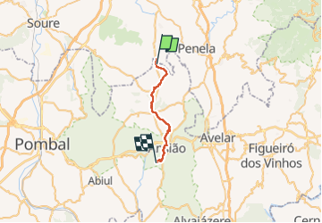

Length
21 km

Max alt
302 m

Uphill gradient
412 m
Km-Effort
26 km

Min alt
188 m

Downhill gradient
375 m
Boucle
No
Creation date :
2023-04-10 08:59:42.017
Updated on :
2023-04-10 21:20:17.02
5h38
Difficulty : Medium

FREE GPS app for hiking
 SityTrail
IGN / Geographical institutes
SityTrail World
The world is yours!
About
Trail Walking of 21 km to be discovered at Centro, Leiria, Alvorge. This trail is proposed by berlage.
Positioning
Country:
Portugal
Region :
Centro
Department/Province :
Leiria
Municipality :
Alvorge
Location:
Unknown
Start:(Dec)
Start:(UTM)
546813 ; 4429109 (29T) N.
Comments
Trails nearby