Trail Walking Vagney - Vagney 22 150m +791m - Photo

Vagney 22 150m +791m

© OpenStreetMap contributors
Length
Length
22 km
Max alt
Max alt
854 m
Uphill gradient
Uphill gradient
791 m
Km-Effort
Km-Effort  
33 km
Min alt
Min alt
401 m
Downhill gradient
Downhill gradient
791 m
Boucle
Boucle
Yes
Creation date :
2023-04-10 07:52:54.945
Updated on :
2023-04-10 18:47:01.892

(0 Reviews)

Walking
Walking
7h25
Difficulty : Very difficult

Scan this QR Code to open this trail in the SityTrail application

FREE GPS app for hiking

Logo SityTrail SityTrail

IGN / Geographical institutes

Download SityTrail from the App Store Download SityTrail from Google Play

Logo SityTrail SityTrail World

The world is yours!

Download SityTrail from the App Store Download SityTrail from Google Play Download SityTrail on Huawei AppGallery

About

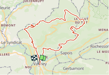
Trail Walking of 22 km to be discovered at Grand Est, Vosges, Vagney. This trail is proposed by DanielROLLET.

Description

2023 04 10 - 10h05 à 17h25 - Beau temps mais frais
Avec Marie
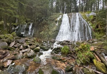
Pause au saut de la Bourrique, pas recommandé : beaucoup de monde, très froid, pas d'endroit ensoleillé pour pique-niquer.
Départ mairie de Vagney - Chèvre-Roche - saut de la Bourrique - Haut du tôt - Moyemont - Balcon de la Hazelle - retour mairie Vagney.
Perdu la carte! Téléphone déconne!
Nombreux malaises entre le Haut du Tôt et Moyemont.

Elevation profile

Positioning

Country:
France
Region :
Grand Est
Department/Province :
Vosges
Municipality :
Vagney
Location:
Unknown
Start:(UTM)
329632 ; 5319787 (32U) N.

Trails nearby

Trail Walking Sapois - La Cascade de la Pissoire - Photo
Walking
tracegps

Walking

Medium
(2)
Sapois, Grand Est, Vosges, France
6.3 km | 8.9 km-effort
2h 0min
Yes
Trail Walking Saint-Amé - carrière de Saint Amé - Photo
Walking
EricMathieu

Walking

Medium
(1)
Saint-Amé, Grand Est, Vosges, France
8.6 km | 12.6 km-effort
2h 13min
Yes
Trail Walking Le Syndicat - Balcon du Solem - Photo
Walking
tracegps

Walking

Medium
(1)
Le Syndicat, Grand Est, Vosges, France
4.3 km | 7.4 km-effort
2h 0min
Yes
Trail Walking Sapois - La Cascade de la Pissoire - Photo
Walking
GUIDE
Desrumaux

Walking

Easy
(3)
Sapois, Grand Est, Vosges, France
6.3 km | 8.9 km-effort
1h 40min
Yes
Trail Walking Vecoux - Chaudefontaine -grand lac- Chaudefontaine  - Photo
Walking
nicolasdresse

Walking

Difficult
Vecoux, Grand Est, Vosges, France
8.6 km | 13.4 km-effort
3h 2min
Yes
Trail Walking Thiéfosse - tiens vagbey gorge de croqery - Photo
Walking
ghislaine61

Walking

Medium
Thiéfosse, Grand Est, Vosges, France
8.9 km | 12 km-effort
2h 47min
Yes
Trail Walking Vecoux - Chalet avuxon / La Vrille / Col de Xiard variante - Photo
Walking
Emmanuel Remy

Walking

Difficult
(1)
Vecoux, Grand Est, Vosges, France
12.3 km | 19.1 km-effort
4h 20min
Yes
Trail Walking Gerbamont - cascadu bouchot vosges - Photo
Walking
ghislaine61

Walking

Medium
(1)
Gerbamont, Grand Est, Vosges, France
7.9 km | 10.5 km-effort
2h 23min
Yes
Trail Walking Thiéfosse - Randonnée du 23/08/2022 à 17:17 - Photo
Walking
nfranche

Walking

Very difficult
Thiéfosse, Grand Est, Vosges, France
18.5 km | 28 km-effort
6h 19min
Yes


Close
My subscriptions