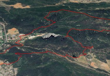
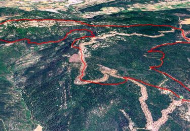
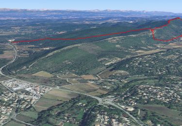
![](/images/other/stat-length.png)
![Trail Walking Brignoles - l'Amarron - Photo](https://media.geolcdn.com/t/1900/400/9224daff-cf2d-4732-bd80-bafe4a1696c0.jpg&format=pjpeg&maxdim=2)
l'Amarron
FSantoni
User
![Length](/images/other/stat-length.png)
![Max alt](https://static1.geolcdn.com/siteimages/upload/files/1508320355ic_sort_altitude_max_24dp.png)
![Uphill gradient](https://static1.geolcdn.com/siteimages/upload/files/1508320355ic_sort_den_pos_24dp.png)
![Km-Effort](/images/other/stat-length.png)
![Min alt](https://static1.geolcdn.com/siteimages/upload/files/1508320355ic_sort_altitude_min_24dp.png)
![Downhill gradient](https://static1.geolcdn.com/siteimages/upload/files/1508320355ic_sort_den_neg_24dp.png)
![Boucle](https://static1.geolcdn.com/siteimages/upload/files/16400158638029165_repeat_loop_refresh_sync_direction_icon.png)
![Walking](https://static1.geolcdn.com/sitytour/trail-icons/101.png)
6h38
Difficulty : Difficult
![Scan this QR Code to open this trail in the SityTrail application](https://capi.geolives.com/qq0zvz2zws4bq2lad0pu/sitytour/trails/3616159/qr.png?size=200)
FREE GPS app for hiking
About
Trail Walking of 8.7 km to be discovered at Provence-Alpes-Côte d'Azur, Var, Brignoles. This trail is proposed by FSantoni.
Description
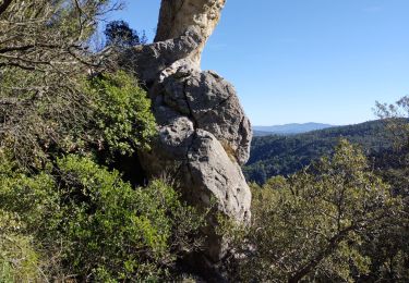
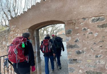
Montée plutôt pentue, mais globalement agréable, avec au sommet un magnifique point de vue.
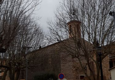
La descente est moins sympa car visiblement le chemin est peu usité, donc pas toujours visible (on s'est dailleurs égarés 2 fois !), et assez dangereux par la nature du sol et les nombreux ravinements, avec cependant de très beaux paysages minéraux.
Positioning
Comments
Trails nearby
![Trail Walking La Celle - Trace_La_Celle - Photo](https://media.geolcdn.com/t/375/260/367c307f-f133-49ff-990b-24c0026569ab.jpg&format=jpg&maxdim=2)
![Walking Walking](https://static1.geolcdn.com/sitytour/trail-icons/101.png)
Walking
![](/images/other/stat-length.png)
![](https://static1.geolcdn.com/siteimages/upload/files/16400158638029165_repeat_loop_refresh_sync_direction_icon.png)
![Trail Walking La Celle - L'Escarelle 1 - Photo](https://media.geolcdn.com/t/375/260/ext.jpg?maxdim=2&url=https%3A%2F%2Fstatic1.geolcdn.com%2Fsiteimages%2Fupload%2Ffiles%2F1553511878bg_sport_marche.png)
![Walking Walking](https://static1.geolcdn.com/sitytour/trail-icons/101.png)
Walking
![](/images/other/stat-length.png)
![](https://static1.geolcdn.com/siteimages/upload/files/16400158638029165_repeat_loop_refresh_sync_direction_icon.png)
![Trail Walking Camps-la-Source - Rocher du Gueit- Camps la Source-06-11-2024 - Photo](https://media.geolcdn.com/t/375/260/e92a19e7-d25b-4cc7-a41e-f3e4999745e6.jpg&format=jpg&maxdim=2)
![Walking Walking](https://static1.geolcdn.com/sitytour/trail-icons/101.png)
Walking
![](/images/other/stat-length.png)
![](https://static1.geolcdn.com/siteimages/upload/files/16400158638029165_repeat_loop_refresh_sync_direction_icon.png)
![Trail Walking La Celle - Roc de Candelon - Photo](https://media.geolcdn.com/t/375/260/a9cfb2ad-a53d-4040-a9b9-a70f08f9f434.jpg&format=jpg&maxdim=2)
![Walking Walking](https://static1.geolcdn.com/sitytour/trail-icons/101.png)
Walking
![](/images/other/stat-length.png)
![](https://static1.geolcdn.com/siteimages/upload/files/16400158638029165_repeat_loop_refresh_sync_direction_icon.png)
![Trail Walking La Roquebrussanne - chapelle St André et grotte des irris - Photo](https://media.geolcdn.com/t/375/260/c17b726b-2dcc-44be-a87c-f260edf4e94a.jpg&format=jpg&maxdim=2)
![Walking Walking](https://static1.geolcdn.com/sitytour/trail-icons/101.png)
Walking
![](/images/other/stat-length.png)
![](https://static1.geolcdn.com/siteimages/upload/files/16400158638029165_repeat_loop_refresh_sync_direction_icon.png)
![Trail Walking Garéoult - L'Amarron depuis Garéoult - Photo](https://media.geolcdn.com/t/375/260/47c5c3b8-59ea-460f-b034-de18890572e7.jpg&format=jpg&maxdim=2)
![Walking Walking](https://static1.geolcdn.com/sitytour/trail-icons/101.png)
Walking
![](/images/other/stat-length.png)
![](https://static1.geolcdn.com/siteimages/upload/files/16400158638029165_repeat_loop_refresh_sync_direction_icon.png)
![Trail Walking Camps-la-Source - Barres de St Quinis par Camps la Source - Photo](https://media.geolcdn.com/t/375/260/350601e3-1f72-40c6-8d5a-a3df47012346.jpg&format=jpg&maxdim=2)
![Walking Walking](https://static1.geolcdn.com/sitytour/trail-icons/101.png)
Walking
![](/images/other/stat-length.png)
![](https://static1.geolcdn.com/siteimages/upload/files/16400158638029165_repeat_loop_refresh_sync_direction_icon.png)
![Trail Walking La Celle - Celle : la Loube et l'Amarron - Photo](https://media.geolcdn.com/t/375/260/c913ba8d-bcb8-4648-a445-1dd1f4815812.jpg&format=jpg&maxdim=2)
![Walking Walking](https://static1.geolcdn.com/sitytour/trail-icons/101.png)
Walking
![](/images/other/stat-length.png)
![](https://static1.geolcdn.com/siteimages/upload/files/16400158638029165_repeat_loop_refresh_sync_direction_icon.png)
![Trail Walking La Celle - La Celle-19-02-21 - Photo](https://media.geolcdn.com/t/375/260/8fcb5456-c13d-4ae0-a903-c2fb80e2afa9.jpg&format=jpg&maxdim=2)
![Walking Walking](https://static1.geolcdn.com/sitytour/trail-icons/101.png)
Walking
![](/images/other/stat-length.png)
![](https://static1.geolcdn.com/siteimages/upload/files/16400158638029165_repeat_loop_refresh_sync_direction_icon.png)