Trail Walking Portet-d'Aspet - Crête de Cournudère - Photo
 toutankhcarton
toutankhcarton

User GUIDE

© OpenStreetMap contributors
Length
Length
12.8 km
Max alt
Max alt
1575 m
Uphill gradient
Uphill gradient
680 m
Km-Effort
Km-Effort  
22 km
Min alt
Min alt
1069 m
Downhill gradient
Downhill gradient
679 m
Boucle
Boucle
Yes
Creation date :
2023-04-10 07:45:22.756
Updated on :
2023-04-10 15:24:51.31

(0 Reviews)

Walking
Walking
4h58
Difficulty : Easy

Scan this QR Code to open this trail in the SityTrail application

FREE GPS app for hiking

Logo SityTrail SityTrail

IGN / Geographical institutes

Download SityTrail from the App Store Download SityTrail from Google Play

Logo SityTrail SityTrail World

The world is yours!

Download SityTrail from the App Store Download SityTrail from Google Play Download SityTrail on Huawei AppGallery

About

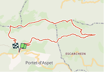
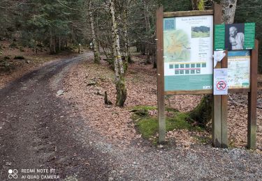
Trail Walking of 12.8 km to be discovered at Occitania, Haute-Garonne, Portet-d'Aspet. This trail is proposed by toutankhcarton.

Description

Départ du col du Portet d'Aspet. Passage par col de Saraoute, crête du Cap des Teches.
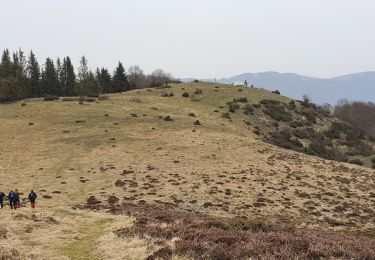
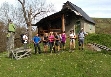
Descente par le Pas de l'âne (1509m) pour remonter le Tuc de Tucol et redescendre à gauche de la cabane de Cournudère.
Retour au parking par la piste forestière.

Elevation profile

Positioning

Country:
France
Region :
Occitania
Department/Province :
Haute-Garonne
Municipality :
Portet-d'Aspet
Location:
Unknown
Start:(UTM)
324936 ; 4756951 (31T) N.

Trails nearby

Trail Mountain bike Milhas - Espace VTT FFC Pyrénées Comminges - n° 29 Le balcon du Cagire - Photo
Mountain bike
tracegps

Mountain bike

Difficult
(2)
Milhas, Occitania, Haute-Garonne, France
11.8 km | 18.7 km-effort
1h 45min
Yes
Trail Walking Portet-d'Aspet - 2023 09 21 CHEMIN du PIÉMONT PYRÉNÉEN - 14ème étape : Portet-d’Aspet - le Col - Juzet-d’Izaut - St  Pet-d’Ardet - Barbazan - Valcabrère - st Bertrand de Comminges - Photo
Walking
LEGUE

Walking

Very difficult
Portet-d'Aspet, Occitania, Haute-Garonne, France
46 km | 67 km-effort
8h 46min
No
Trail Walking Herran - 2020-08-20 Arbas -  cabane de roqué pic -  de paloumère - sommet de cornudère. - Photo
Walking
jacq58

Walking

Medium
Herran, Occitania, Haute-Garonne, France
13.2 km | 23 km-effort
4h 14min
Yes
Trail Walking Herran - Balade Coume Paloumere - Photo
Walking
Timax31

Walking

Very difficult
Herran, Occitania, Haute-Garonne, France
11.1 km | 19.5 km-effort
5h 6min
Yes
Trail Walking Portet-d'Aspet - Le Puech et cabane de Piejeau en boucle - Photo
Walking
chrisgps

Walking

Easy
Portet-d'Aspet, Occitania, Haute-Garonne, France
12.4 km | 22 km-effort
5h 43min
Yes
Trail Walking Boutx - Cap de Gauch (2148m) depuis Coulédoux - Photo
Walking
Rouzier

Walking

Medium
Boutx, Occitania, Haute-Garonne, France
15 km | 32 km-effort
5h 54min
Yes
Trail Mountain bike Herran - Espace VTT FFC Pyrénées Comminges - n° 33 La croix de Guéret  - Photo
Mountain bike
tracegps

Mountain bike

Very difficult
Herran, Occitania, Haute-Garonne, France
12.2 km | 21 km-effort
1h 45min
Yes
Trail Mountain bike Galey - Galey Puech Galey - Photo
Mountain bike
Yonl

Mountain bike

Very difficult
Galey, Occitania, Ariège, France
32 km | 52 km-effort
6h 40min
Yes
Trail Mountain bike Galey - Galey VTT électrique - Photo
Mountain bike
Yonl

Mountain bike

Difficult
Galey, Occitania, Ariège, France
13.7 km | 19.8 km-effort
2h 10min
Yes


Close
My subscriptions