![](/images/other/stat-length.png)
![Trail Bicycle tourism Malestroit - Eurovélo : de Malestroit à Josselin - Photo](https://media.geolcdn.com/t/1900/400/29ff9d02-fe3d-42ab-b964-bae8a1fe7eb4.jpg&format=pjpeg&maxdim=2)
Eurovélo : de Malestroit à Josselin
ilur56
User
![Length](/images/other/stat-length.png)
Length
51 km
![Max alt](https://static1.geolcdn.com/siteimages/upload/files/1508320355ic_sort_altitude_max_24dp.png)
Max alt
47 m
![Uphill gradient](https://static1.geolcdn.com/siteimages/upload/files/1508320355ic_sort_den_pos_24dp.png)
Uphill gradient
383 m
![Km-Effort](/images/other/stat-length.png)
Km-Effort
57 km
![Min alt](https://static1.geolcdn.com/siteimages/upload/files/1508320355ic_sort_altitude_min_24dp.png)
Min alt
11 m
![Downhill gradient](https://static1.geolcdn.com/siteimages/upload/files/1508320355ic_sort_den_neg_24dp.png)
Downhill gradient
384 m
![Boucle](https://static1.geolcdn.com/siteimages/upload/files/16400158638029165_repeat_loop_refresh_sync_direction_icon.png)
Boucle
Yes
Creation date :
2023-04-07 08:47:14.333
Updated on :
2023-04-09 13:22:50.337
![Bicycle tourism](https://static1.geolcdn.com/sitytour/trail-icons/204.png)
--
Difficulty : Very difficult
![Scan this QR Code to open this trail in the SityTrail application](https://capi.geolives.com/qq0zvz2zws4bq2lad0pu/sitytour/trails/3612680/qr.png?size=200)
FREE GPS app for hiking
About
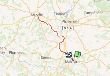
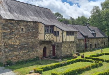
Trail Bicycle tourism of 51 km to be discovered at Brittany, Morbihan, Malestroit. This trail is proposed by ilur56.
Description
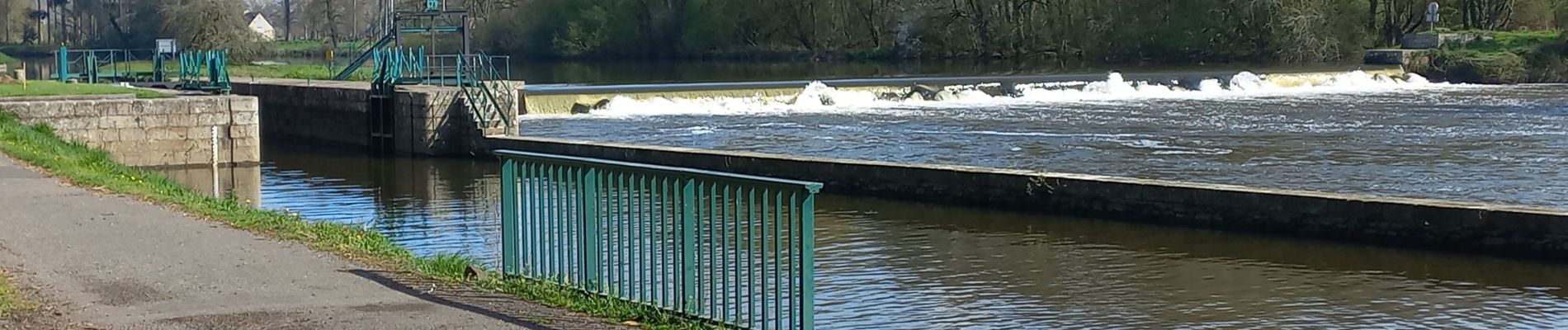
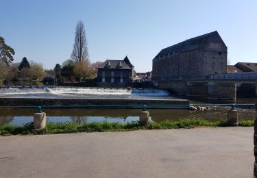
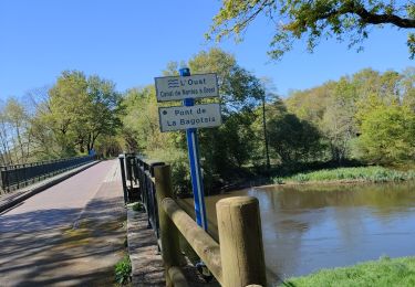
Le long du canal de Nantes à Brest, un aller-retour entre les villes de Malestroit et de Josselin sur le chemin de halage à vélo.
Positioning
Country:
France
Region :
Brittany
Department/Province :
Morbihan
Municipality :
Malestroit
Location:
Unknown
Start:(Dec)
Start:(UTM)
546153 ; 5295513 (30T) N.
Comments
Trails nearby
![Trail Walking Saint-Laurent-sur-Oust - Gr-347_03_St-Laurent-Sur-Oust_La-Ville-André _20190332 - Photo](https://media.geolcdn.com/t/375/260/16c87b33-7868-4a56-a383-13a739f11a40.jpg&format=jpg&maxdim=2)
![Walking Walking](https://static1.geolcdn.com/sitytour/trail-icons/101.png)
Gr-347_03_St-Laurent-Sur-Oust_La-Ville-André _20190332
Walking
Easy
Saint-Laurent-sur-Oust,
Brittany,
Morbihan,
France
![](/images/other/stat-length.png)
19.1 km | 23 km-effort
4h 20min
![](https://static1.geolcdn.com/siteimages/upload/files/16400158638029165_repeat_loop_refresh_sync_direction_icon.png)
No
![Trail Nordic walking Malestroit - grand tour de l' Oust au canal Malestroit - Photo](https://media.geolcdn.com/t/375/260/fafcc30b-cf9e-40cc-8662-4a0a98e2b5cf.jpg&format=jpg&maxdim=2)
![Nordic walking Nordic walking](https://static1.geolcdn.com/sitytour/trail-icons/102.png)
grand tour de l' Oust au canal Malestroit
Nordic walking
Medium
Malestroit,
Brittany,
Morbihan,
France
![](/images/other/stat-length.png)
10.9 km | 11.8 km-effort
2h 48min
![](https://static1.geolcdn.com/siteimages/upload/files/16400158638029165_repeat_loop_refresh_sync_direction_icon.png)
No
![Trail Nordic walking Saint-Marcel - voie. verte Malestroit - Photo](https://media.geolcdn.com/t/375/260/ext.jpg?maxdim=2&url=https%3A%2F%2Fservices.sitytrail.com%2FGeolivesWS%2FDownloadMedia.ashx%3FTrailID%3D178725%26Media%3D20130308190622.jpg)
![Nordic walking Nordic walking](https://static1.geolcdn.com/sitytour/trail-icons/102.png)
voie. verte Malestroit
Nordic walking
Very easy
Saint-Marcel,
Brittany,
Morbihan,
France
![](/images/other/stat-length.png)
10 km | 11.3 km-effort
1h 47min
![](https://static1.geolcdn.com/siteimages/upload/files/16400158638029165_repeat_loop_refresh_sync_direction_icon.png)
Yes
![Trail Walking Malestroit - Malestroit CA 4 05 2023 - Photo](https://media.geolcdn.com/t/375/260/d94dc8a5-4f86-4c28-a219-08a198ddf1d3.jpg&format=jpg&maxdim=2)
![Walking Walking](https://static1.geolcdn.com/sitytour/trail-icons/101.png)
Malestroit CA 4 05 2023
Walking
Medium
Malestroit,
Brittany,
Morbihan,
France
![](/images/other/stat-length.png)
19 km | 22 km-effort
4h 20min
![](https://static1.geolcdn.com/siteimages/upload/files/16400158638029165_repeat_loop_refresh_sync_direction_icon.png)
Yes
![Trail Walking Malestroit - Boucle de L'Oust au canal de Nantes à Brest à partir de Malestroit - Photo](https://media.geolcdn.com/t/375/260/ext.jpg?maxdim=2&url=https%3A%2F%2Fstatic1.geolcdn.com%2Fsiteimages%2Fupload%2Ffiles%2F1553511878bg_sport_marche.png)
![Walking Walking](https://static1.geolcdn.com/sitytour/trail-icons/101.png)
Boucle de L'Oust au canal de Nantes à Brest à partir de Malestroit
Walking
Easy
Malestroit,
Brittany,
Morbihan,
France
![](/images/other/stat-length.png)
16.7 km | 18.1 km-effort
4h 1min
![](https://static1.geolcdn.com/siteimages/upload/files/16400158638029165_repeat_loop_refresh_sync_direction_icon.png)
Yes
![Trail Walking Malestroit - Canal Nantes à Brest Jour 6 - Photo](https://media.geolcdn.com/t/375/260/ext.jpg?maxdim=2&url=https%3A%2F%2Fstatic1.geolcdn.com%2Fsiteimages%2Fupload%2Ffiles%2F1553511878bg_sport_marche.png)
![Walking Walking](https://static1.geolcdn.com/sitytour/trail-icons/101.png)
Canal Nantes à Brest Jour 6
Walking
Medium
Malestroit,
Brittany,
Morbihan,
France
![](/images/other/stat-length.png)
26 km | 29 km-effort
6h 18min
![](https://static1.geolcdn.com/siteimages/upload/files/16400158638029165_repeat_loop_refresh_sync_direction_icon.png)
No
![Trail Walking Bohal - bohl - Photo](https://media.geolcdn.com/t/375/260/ext.jpg?maxdim=2&url=https%3A%2F%2Fstatic1.geolcdn.com%2Fsiteimages%2Fupload%2Ffiles%2F1553511878bg_sport_marche.png)
![Walking Walking](https://static1.geolcdn.com/sitytour/trail-icons/101.png)
![Trail Nordic walking Malestroit - MALESTROIR 18 06 13 - Photo](https://media.geolcdn.com/t/375/260/ext.jpg?maxdim=2&url=https%3A%2F%2Fstatic1.geolcdn.com%2Fsiteimages%2Fupload%2Ffiles%2F1545311037marcheuse_200dpi.jpg)
![Nordic walking Nordic walking](https://static1.geolcdn.com/sitytour/trail-icons/102.png)
MALESTROIR 18 06 13
Nordic walking
Very easy
Malestroit,
Brittany,
Morbihan,
France
![](/images/other/stat-length.png)
11.4 km | 12.7 km-effort
2h 10min
![](https://static1.geolcdn.com/siteimages/upload/files/16400158638029165_repeat_loop_refresh_sync_direction_icon.png)
Yes
![Trail Walking Malestroit - Sentier de la rivière - Malestroit - Photo](https://media.geolcdn.com/t/375/260/ext.jpg?maxdim=2&url=https%3A%2F%2Fstatic1.geolcdn.com%2Fsiteimages%2Fupload%2Ffiles%2F1553511878bg_sport_marche.png)
![Walking Walking](https://static1.geolcdn.com/sitytour/trail-icons/101.png)
Sentier de la rivière - Malestroit
Walking
Medium
Malestroit,
Brittany,
Morbihan,
France
![](/images/other/stat-length.png)
14.1 km | 15.4 km-effort
4h 0min
![](https://static1.geolcdn.com/siteimages/upload/files/16400158638029165_repeat_loop_refresh_sync_direction_icon.png)
Yes