Trail Horseback riding Saint-Augustin - stacy - Photo
© OpenStreetMap contributors
Length
Length
2.1 km
Max alt
Max alt
132 m
Uphill gradient
Uphill gradient
28 m
Km-Effort
Km-Effort  
2.4 km
Min alt
Min alt
109 m
Downhill gradient
Downhill gradient
11 m
Boucle
Boucle
No
Creation date :
2023-04-03 09:34:14.405
Updated on :
2023-04-03 11:24:29.78

(0 Reviews)

Horseback riding
Horseback riding
1h48
Difficulty : Easy

Scan this QR Code to open this trail in the SityTrail application

FREE GPS app for hiking

Logo SityTrail SityTrail

IGN / Geographical institutes

Download SityTrail from the App Store Download SityTrail from Google Play

Logo SityTrail SityTrail World

The world is yours!

Download SityTrail from the App Store Download SityTrail from Google Play Download SityTrail on Huawei AppGallery

About

Trail Horseback riding of 2.1 km to be discovered at Ile-de-France, Seine-et-Marne, Saint-Augustin. This trail is proposed by samanthavoutier@gmail.com .

Description

St aubuerge

Elevation profile

Positioning

Country:
France
Region :
Ile-de-France
Department/Province :
Seine-et-Marne
Municipality :
Saint-Augustin
Location:
Unknown
Start:(UTM)
501512 ; 5401485 (31U) N.

Trails nearby

Trail Mountain bike Saint-Augustin - Espace VTT FFC - Les Coteaux du Morin et de l'Aubetin - Circuit n° 15 - Saint Augustin - Photo
Mountain bike
tracegps

Mountain bike

Medium
(1)
Saint-Augustin, Ile-de-France, Seine-et-Marne, France
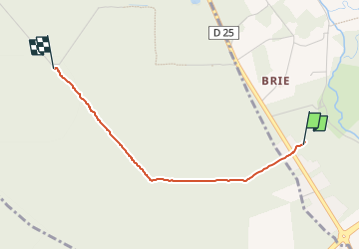
12 km | 14.4 km-effort
1h 0min
Yes
Trail On foot Pommeuse - Les lavoirs de Pommeuse - Photo
On foot
GUIDE
chessyca

On foot

Medium
Pommeuse, Ile-de-France, Seine-et-Marne, France
22 km | 26 km-effort
5h 57min
Yes
Trail Walking Coulommiers - COULOMMIERS > FAREMOUTIERS 18 KM - Photo
Walking
gemau77

Walking

Very easy
(1)
Coulommiers, Ile-de-France, Seine-et-Marne, France
18.2 km | 22 km-effort
4h 40min
No
Trail sport Hautefeuille - 2019-08-10_23h17m35_parcours_Hautefeuille - Photo
sport
mouma_77

sport

Very easy
(1)
Hautefeuille, Ile-de-France, Seine-et-Marne, France
15.3 km | 17.2 km-effort
Unknown
Yes
Trail Walking Faremoutiers - Faremoutiers - Photo
Walking
PatRando

Walking

Easy
Faremoutiers, Ile-de-France, Seine-et-Marne, France
22 km | 25 km-effort
5h 26min
Yes
Trail Walking Beautheil-Saints - Saints - Photo
Walking
Bernardroland

Walking

Easy
Beautheil-Saints, Ile-de-France, Seine-et-Marne, France
18.4 km | 21 km-effort
5h 10min
Yes
Trail Walking La Celle-sur-Morin - M&R-121026 - LaCelle-ValléeMorin - Photo
Walking
randodan

Walking

Very easy
La Celle-sur-Morin, Ile-de-France, Seine-et-Marne, France
18.6 km | 22 km-effort
4h 48min
Yes
Trail Walking Touquin - Touquin - Photo
Walking
Bernardroland

Walking

Very easy
Touquin, Ile-de-France, Seine-et-Marne, France
17.7 km | 20 km-effort
4h 10min
Yes
Trail Walking Beautheil-Saints - Saint  - Photo
Walking
pikibangi

Walking

Very difficult
Beautheil-Saints, Ile-de-France, Seine-et-Marne, France
23 km | 26 km-effort
4h 48min
Yes


Close
My subscriptions