Trail On foot Sainte-Croix - The gorges of Covatannaz - Photo
 famiski
famiski

User

© OpenStreetMap contributors
Length
Length
5.5 km
Max alt
Max alt
1073 m
Uphill gradient
Uphill gradient
19 m
Km-Effort
Km-Effort  
7.4 km
Min alt
Min alt
587 m
Downhill gradient
Downhill gradient
501 m
Boucle
Boucle
No
Creation date :
2023-03-25 06:33:51.01
Updated on :
2023-03-25 06:34:14.971

(0 Reviews)

On foot
On foot
1h40
Difficulty : Easy

Scan this QR Code to open this trail in the SityTrail application

FREE GPS app for hiking

Logo SityTrail SityTrail

IGN / Geographical institutes

Download SityTrail from the App Store Download SityTrail from Google Play

Logo SityTrail SityTrail World

The world is yours!

Download SityTrail from the App Store Download SityTrail from Google Play Download SityTrail on Huawei AppGallery

About

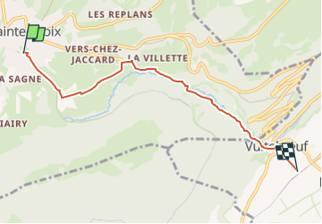
Trail On foot of 5.5 km to be discovered at Vaud, District du Jura-Nord vaudois, Sainte-Croix. This trail is proposed by famiski.

Description

Leaving from the station of Sainte-Croix, the hike starts by following the marked route alongside the railway line. The hike continues across open pastures before leading into the midst of the forest running alongside the river Arnon. Over the course of time, this river that shaped the gorges of Covatannaz and its impressive cliffs. The trail then leads downward, keeping pace with large and sets of rapids and cascades before arriving at the site of Fontanet with its vast clearing, an ideal place to appreciate while having a picnic.

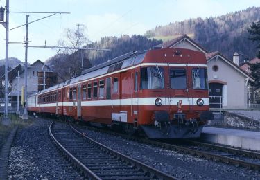
A few metres higher up, walkers will come to a road junction giving access to Baulmes after an extra 2 km, or follow the signs to Vuiteboeuf. From there, the panoramic train ‘Travys’ takes the hikers back to Sainte-Croix via Baulmes, or Yverdon-les-Bains.

Elevation profile

Points of interest

Point of interest Sainte-Croix - Tourist Office Sainte-Croix / Les Rasses - Photo
famiski
Point of interest Sainte-Croix - The gorges of Covatannaz - Photo
famiski

Positioning

Country:
Switzerland
Region :
Vaud
Department/Province :
District du Jura-Nord vaudois
Municipality :
Sainte-Croix
Location:
Unknown
Start:(UTM)
309362 ; 5188140 (32T) N.

Trails nearby

Trail On foot La Côte-aux-Fées - La Côte-aux-Fées - Buttes - Photo
On foot
GUIDE+

On foot

Easy
La Côte-aux-Fées, Neuchâtel, Unknown, Switzerland
6.7 km | 8.5 km-effort
1h 55min
No
Trail On foot Sainte-Croix - La Gittaz-Col de l'Aigullon - Photo
On foot
GUIDE+

On foot

Easy
Sainte-Croix, Vaud, District du Jura-Nord vaudois, Switzerland
4.1 km | 6.4 km-effort
1h 26min
No
Trail On foot Sainte-Croix - Sainte Croix-La Gittaz - Photo
On foot
GUIDE+

On foot

Easy
Sainte-Croix, Vaud, District du Jura-Nord vaudois, Switzerland
5.7 km | 8.3 km-effort
1h 53min
No
Trail On foot Sainte-Croix - Chemin de la Gare - Photo
On foot
GUIDE+

On foot

Easy
Sainte-Croix, Vaud, District du Jura-Nord vaudois, Switzerland
6.5 km | 8.6 km-effort
1h 57min
No
Trail Walking Jougne - Aiguilles de Baulmes - Suisse - Photo
Walking
albert39

Walking

Difficult
(1)
Jougne, Bourgogne-Franche-Comté, Doubs, France
16.4 km | 26 km-effort
5h 33min
Yes
Trail Walking Sainte-Croix - le Chasseron par les avattes - Photo
Walking
viam19

Walking

Medium
Sainte-Croix, Vaud, District du Jura-Nord vaudois, Switzerland
13.3 km | 20 km-effort
4h 18min
Yes
Trail Walking Jougne - aiguilles de Baulmes et retour  Suchet  - Photo
Walking
BM25

Walking

Very easy
Jougne, Bourgogne-Franche-Comté, Doubs, France
23 km | 37 km-effort
6h 31min
Yes
Trail Snowshoes Sainte-Croix - Col des Etroits Le Chasseron CAF - Photo
Snowshoes
TRIMAILLE

Snowshoes

Difficult
Sainte-Croix, Vaud, District du Jura-Nord vaudois, Switzerland
12.2 km | 19.9 km-effort
Unknown
Yes
Trail Walking Sainte-Croix - Sentier des bornes sud  - Photo
Walking
mallovon

Walking

Very easy
Sainte-Croix, Vaud, District du Jura-Nord vaudois, Switzerland
6.7 km | 8.7 km-effort
2h 46min
Yes


Close
My subscriptions