Trail On foot Romainmôtier-Envy - Sentier du patrimoine de Romainmôtier - Photo

Sentier du patrimoine de Romainmôtier

 famiski
famiski

User

© OpenStreetMap contributors
Length
Length
13.2 km
Max alt
Max alt
712 m
Uphill gradient
Uphill gradient
319 m
Km-Effort
Km-Effort  
17.4 km
Min alt
Min alt
551 m
Downhill gradient
Downhill gradient
319 m
Boucle
Boucle
Yes
Creation date :
2023-03-25 06:31:09.334
Updated on :
2023-03-25 06:44:57.29

(0 Reviews)

On foot
On foot
3h57
Difficulty : Easy

Scan this QR Code to open this trail in the SityTrail application

FREE GPS app for hiking

Logo SityTrail SityTrail

IGN / Geographical institutes

Download SityTrail from the App Store Download SityTrail from Google Play

Logo SityTrail SityTrail World

The world is yours!

Download SityTrail from the App Store Download SityTrail from Google Play Download SityTrail on Huawei AppGallery

About

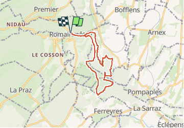
Trail On foot of 13.2 km to be discovered at Vaud, District du Jura-Nord vaudois, Romainmôtier-Envy. This trail is proposed by famiski.

Description

You will discover varied biotopes along your way. Depending on the season, you will see the river banks covered with spring snowflakes or with bear's garlic. Bunches of box trees and lean oak trees grow on the rocks above the cliffs, conferring a Mediterranean look to the landscape.

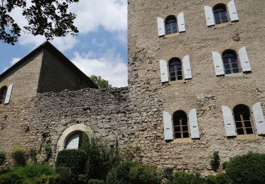
Humans have left their mark in these wild forests throughout history: prehistoric stones with strange signs, ovens to reduce iron ore, limekilns, quarries to exploit ashlars or to make the magnificent fountain basins featured in the villages of the Lake Geneva Region.

Along the way you will discover a quarry where many basins of our region were made. You will also see vestiges of iron ovens and limekilns, as well as an engraved stone in a place called Les Gottettes. Back in Croy, don't miss the ancient public wash houses and fountains.

Elevation profile

Points of interest

Point of interest Romainmôtier-Envy - Romainmôtier Abbey Church - Photo
famiski
ROMAINMÔTIER-ENVY 

Positioning

Country:
Switzerland
Region :
Vaud
Department/Province :
District du Jura-Nord vaudois
Municipality :
Romainmôtier-Envy
Location:
Unknown
Start:(UTM)
305876 ; 5174262 (32T) N.

Trails nearby

Trail On foot Les Clées - fixme - fixme - Photo
On foot
GUIDE+

On foot

Easy
Les Clées, Vaud, District du Jura-Nord vaudois, Switzerland
4.1 km | 5.9 km-effort
1h 20min
No
Trail On foot Les Clées - Tourisme pédestre - Photo
On foot
GUIDE+

On foot

Easy
Les Clées, Vaud, District du Jura-Nord vaudois, Switzerland
3.5 km | 4.5 km-effort
1h 0min
No
Trail On foot Ballaigues - Ballaigues-Vallorbe - Photo
On foot
GUIDE+

On foot

Easy
Ballaigues, Vaud, District du Jura-Nord vaudois, Switzerland
5.1 km | 6.3 km-effort
1h 25min
No
Trail On foot Juriens - TP Mollendruz - Romainmôtie - Photo
On foot
GUIDE+

On foot

Easy
Juriens, Vaud, District du Jura-Nord vaudois, Switzerland
7.8 km | 11.6 km-effort
2h 38min
No
Trail On foot Montcherand - Chemin nature pour tous - Photo
On foot
GUIDE+

On foot

Easy
Montcherand, Vaud, District du Jura-Nord vaudois, Switzerland
3.8 km | 5.3 km-effort
1h 11min
No
Trail Other activity Romainmôtier-Envy - y10_Cascade du Dard - Photo
Other activity
GUIDE+

Other activity

Very easy
Romainmôtier-Envy, Vaud, District du Jura-Nord vaudois, Switzerland
7.4 km | 8.7 km-effort
2h 7min
No
Trail Other activity Romainmôtier-Envy - y10_brunnen_romainmoitier - Photo
Other activity
GUIDE+

Other activity

Very easy
Romainmôtier-Envy, Vaud, District du Jura-Nord vaudois, Switzerland
10.3 km | 13.1 km-effort
3h 17min
Yes
Trail Other activity Vallorbe - Le Day - Le Pont - Photo
Other activity
pierrepraz

Other activity

Very easy
Vallorbe, Vaud, District du Jura-Nord vaudois, Switzerland
11.2 km | 20 km-effort
Unknown
No
Trail Other activity La Praz - juriens - marchairuz - Photo
Other activity
bertrandrimaz

Other activity

Very easy
La Praz, Vaud, District du Jura-Nord vaudois, Switzerland
10.3 km | 15.4 km-effort
Unknown
No


Close
My subscriptions