![](/images/other/stat-length.png)
![Trail On foot Lausanne - La Grande Traversée - Photo](https://media.geolcdn.com/t/1900/400/ext.pjpeg?maxdim=2&url=https%3A%2F%2Fstatic1.geolcdn.com%2Fsiteimages%2Fupload%2Ffiles%2F1545311037marcheuse_200dpi.jpg)
La Grande Traversée
famiski
User
![Length](/images/other/stat-length.png)
![Max alt](https://static1.geolcdn.com/siteimages/upload/files/1508320355ic_sort_altitude_max_24dp.png)
![Uphill gradient](https://static1.geolcdn.com/siteimages/upload/files/1508320355ic_sort_den_pos_24dp.png)
![Km-Effort](/images/other/stat-length.png)
![Min alt](https://static1.geolcdn.com/siteimages/upload/files/1508320355ic_sort_altitude_min_24dp.png)
![Downhill gradient](https://static1.geolcdn.com/siteimages/upload/files/1508320355ic_sort_den_neg_24dp.png)
![Boucle](https://static1.geolcdn.com/siteimages/upload/files/16400158638029165_repeat_loop_refresh_sync_direction_icon.png)
![On foot](https://static1.geolcdn.com/sitytour/trail-icons/100.png)
11h04
Difficulty : Very difficult
![Scan this QR Code to open this trail in the SityTrail application](https://capi.geolives.com/qq0zvz2zws4bq2lad0pu/sitytour/trails/3595796/qr.png?size=200)
FREE GPS app for hiking
About
Trail On foot of 36 km to be discovered at Vaud, District de Lausanne, Lausanne. This trail is proposed by famiski.
Description
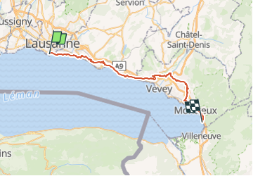
Cette grande traversée conduit du prestigieux Château de Chillon à Lausanne en passant par Montreux, Vevey et Lavaux. Le point de départ est idéalement le Château de Chillon. Ce monument historique, construit sur les rives du lac Léman, représente l'un des plus beaux châteaux de l'Europe médiévale .
Depuis le monument, marcher le long du lac sur les quais fleuris jusqu'à Territet. Monter en traversant le tunnel (passage sous les voies de chemin de fer) et continuer sur le sentier de Collonges. Depuis ce point jusqu'à la fin de la balade, toujours suivre les panneaux bleus du sentier viticole (grappe de raisin avec une tête souriante en forme de soleil).
Monter en direction de la vieille ville en passant par l'Avenue de Collonges, la Rue du Temple, passer devant la charmante Eglise St. Vincent. Continuer à suivre le sentier viticole. Puis, monter sur le sentier des Ramoneurs, Chemin de la Boriodaz, Chemin de la Caudraz, Chemin des Colondalles, emprunter un pont traversant l'autoroute. Toujours en suivant les panneaux du parcours viticole, rejoindre Planchamp-Dessous.
Suivre Route de la Combe, le chemin des Vignerons et de Forchex en dessus de Chailly. Retraverser l'autoroute direction Crotton, puis direction du Château d'Hauteville, Gilamont, Champ de Ban, et rejoindre les villages de Jongny puis plus loin de Chardonne. Depuis Chardonne descente par le vignoble en direction des villages de St. Saphorin et Rivaz puis balade à travers le Dézaley et arrivée à Epesses puis Riex. Continuer en direction de Lausanne en passant par Grandvaux, Aran, Lutry et Pully. Arrivée au Château d'Ouchy.
Positioning
Comments
Trails nearby
![Trail On foot Epalinges - Sur les traces du renard - Photo](https://media.geolcdn.com/t/375/260/dev_c452641b-df55-479e-9313-125a0058811d.jpeg&format=jpg&maxdim=2)
![On foot On foot](https://static1.geolcdn.com/sitytour/trail-icons/100.png)
On foot
![](/images/other/stat-length.png)
![](https://static1.geolcdn.com/siteimages/upload/files/16400158638029165_repeat_loop_refresh_sync_direction_icon.png)
![Trail Walking Lausanne - Lausanne Art Sud - Photo](https://media.geolcdn.com/t/375/260/45a58a1c-c136-43ba-8d7b-e6431cd41120.png&format=jpg&maxdim=2)
![Walking Walking](https://static1.geolcdn.com/sitytour/trail-icons/101.png)
Walking
![](/images/other/stat-length.png)
![](https://static1.geolcdn.com/siteimages/upload/files/16400158638029165_repeat_loop_refresh_sync_direction_icon.png)
![Trail Mountain bike Lutry - Lausanne (Genferseegebiet) - Photo](https://media.geolcdn.com/t/375/260/ext.jpg?maxdim=2&url=https%3A%2F%2Fstatic1.geolcdn.com%2Fsiteimages%2Fupload%2Ffiles%2F1524743154velo.jpg)
![Mountain bike Mountain bike](https://static1.geolcdn.com/sitytour/trail-icons/202.png)
Mountain bike
![](/images/other/stat-length.png)
![](https://static1.geolcdn.com/siteimages/upload/files/16400158638029165_repeat_loop_refresh_sync_direction_icon.png)
![Trail Walking Lausanne - st_ral_08_3 - Photo](https://media.geolcdn.com/t/375/260/ext.jpg?maxdim=2&url=https%3A%2F%2Fstatic1.geolcdn.com%2Fsiteimages%2Fupload%2Ffiles%2F1553511878bg_sport_marche.png)
![Walking Walking](https://static1.geolcdn.com/sitytour/trail-icons/101.png)
Walking
![](/images/other/stat-length.png)
![](https://static1.geolcdn.com/siteimages/upload/files/16400158638029165_repeat_loop_refresh_sync_direction_icon.png)
![Trail On foot Lausanne - BALADE DES PANORAMAS - Photo](https://media.geolcdn.com/t/375/260/ext.jpg?maxdim=2&url=https%3A%2F%2Fstatic1.geolcdn.com%2Fsiteimages%2Fupload%2Ffiles%2F1545311037marcheuse_200dpi.jpg)
![On foot On foot](https://static1.geolcdn.com/sitytour/trail-icons/100.png)
On foot
![](/images/other/stat-length.png)
![](https://static1.geolcdn.com/siteimages/upload/files/16400158638029165_repeat_loop_refresh_sync_direction_icon.png)
![Trail On foot Lutry - Terrasses de Lavaux Lutry - St-Saphorin - Photo](https://media.geolcdn.com/t/375/260/ext.jpg?maxdim=2&url=https%3A%2F%2Fstatic1.geolcdn.com%2Fsiteimages%2Fupload%2Ffiles%2F1545311037marcheuse_200dpi.jpg)
![On foot On foot](https://static1.geolcdn.com/sitytour/trail-icons/100.png)
On foot
![](/images/other/stat-length.png)
![](https://static1.geolcdn.com/siteimages/upload/files/16400158638029165_repeat_loop_refresh_sync_direction_icon.png)
![Trail On foot Lutry - Lutry - Grandvaux - Lutry - Photo](https://media.geolcdn.com/t/375/260/ext.jpg?maxdim=2&url=https%3A%2F%2Fstatic1.geolcdn.com%2Fsiteimages%2Fupload%2Ffiles%2F1545311037marcheuse_200dpi.jpg)
![On foot On foot](https://static1.geolcdn.com/sitytour/trail-icons/100.png)
On foot
![](/images/other/stat-length.png)
![](https://static1.geolcdn.com/siteimages/upload/files/16400158638029165_repeat_loop_refresh_sync_direction_icon.png)
![Trail Car Lausanne - Tour 25 - Photo](https://media.geolcdn.com/t/375/260/ext.jpg?maxdim=2&url=https%3A%2F%2Fstatic1.geolcdn.com%2Fsiteimages%2Fupload%2Ffiles%2F15247431544x4.jpg)
![Car Car](https://static1.geolcdn.com/sitytour/trail-icons/401.png)
![Trail Walking Lausanne - 19.08.16 LeCloselet Jurigoz Mt-Tendre - Photo](https://media.geolcdn.com/t/375/260/ext.jpg?maxdim=2&url=https%3A%2F%2Fstatic1.geolcdn.com%2Fsiteimages%2Fupload%2Ffiles%2F1553511878bg_sport_marche.png)
![Walking Walking](https://static1.geolcdn.com/sitytour/trail-icons/101.png)
Walking
![](/images/other/stat-length.png)
![](https://static1.geolcdn.com/siteimages/upload/files/16400158638029165_repeat_loop_refresh_sync_direction_icon.png)