![](/images/other/stat-length.png)
![Trail Mountain bike Croutelle - croutelle boisée - Photo](https://media.geolcdn.com/t/1900/400/ext.pjpeg?maxdim=2&url=https%3A%2F%2Fstatic1.geolcdn.com%2Fsiteimages%2Fupload%2Ffiles%2F1524743154velo.jpg)
croutelle boisée
makiavelplus
User
![Length](/images/other/stat-length.png)
![Max alt](https://static1.geolcdn.com/siteimages/upload/files/1508320355ic_sort_altitude_max_24dp.png)
![Uphill gradient](https://static1.geolcdn.com/siteimages/upload/files/1508320355ic_sort_den_pos_24dp.png)
![Km-Effort](/images/other/stat-length.png)
![Min alt](https://static1.geolcdn.com/siteimages/upload/files/1508320355ic_sort_altitude_min_24dp.png)
![Downhill gradient](https://static1.geolcdn.com/siteimages/upload/files/1508320355ic_sort_den_neg_24dp.png)
![Boucle](https://static1.geolcdn.com/siteimages/upload/files/16400158638029165_repeat_loop_refresh_sync_direction_icon.png)
![Mountain bike](https://static1.geolcdn.com/sitytour/trail-icons/202.png)
1h29
Difficulty : Medium
![Scan this QR Code to open this trail in the SityTrail application](https://capi.geolives.com/qq0zvz2zws4bq2lad0pu/sitytour/trails/359469/qr.png?size=200)
FREE GPS app for hiking
About
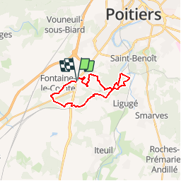
Trail Mountain bike of 18.4 km to be discovered at New Aquitaine, Vienne, Croutelle. This trail is proposed by makiavelplus.
Description
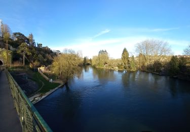
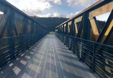
Cette boucle très boisée part de la petite commune du grand poitiers. elle est particulièrement agréable lors des chaudes journées d'été ou à la venu de l'automne. Elle se termine par un apercu de fontaine le compte et de qon abbaye. A noter que cette boucle est aussi intéressante dans un sens que dans l'autre.
Positioning
Comments
Trails nearby
![Trail Walking Poitiers - Poiters St Benoit - Photo](https://media.geolcdn.com/t/375/260/1c049646-5ee2-4f57-842f-e480ac3a3433.jpg&format=jpg&maxdim=2)
![Walking Walking](https://static1.geolcdn.com/sitytour/trail-icons/101.png)
Walking
![](/images/other/stat-length.png)
![](https://static1.geolcdn.com/siteimages/upload/files/16400158638029165_repeat_loop_refresh_sync_direction_icon.png)
![Trail Walking Ligugé - Voie de Tours Ligugé - Lusignan - Photo](https://media.geolcdn.com/t/375/260/d3559b77-50ce-423d-acff-ed52053e525f.jpg&format=jpg&maxdim=2)
![Walking Walking](https://static1.geolcdn.com/sitytour/trail-icons/101.png)
Walking
![](/images/other/stat-length.png)
![](https://static1.geolcdn.com/siteimages/upload/files/16400158638029165_repeat_loop_refresh_sync_direction_icon.png)
![Trail Walking Poitiers - SityTrail - Grottes de la Noree - Photo](https://media.geolcdn.com/t/375/260/bad56a70-0545-4e86-894b-a5e906d8d8a0.jpg&format=jpg&maxdim=2)
![Walking Walking](https://static1.geolcdn.com/sitytour/trail-icons/101.png)
Walking
![](/images/other/stat-length.png)
![](https://static1.geolcdn.com/siteimages/upload/files/16400158638029165_repeat_loop_refresh_sync_direction_icon.png)
![Trail Walking Poitiers - Poitiers intra-muros - Photo](https://media.geolcdn.com/t/375/260/7c65ccee-1131-4d8c-9bc2-4e71491dcdf1.jpg&format=jpg&maxdim=2)
![Walking Walking](https://static1.geolcdn.com/sitytour/trail-icons/101.png)
Walking
![](/images/other/stat-length.png)
![](https://static1.geolcdn.com/siteimages/upload/files/16400158638029165_repeat_loop_refresh_sync_direction_icon.png)
![Trail Walking Poitiers - JFT YB Etape6 02-05-2014 - Photo](https://media.geolcdn.com/t/375/260/ext.jpg?maxdim=2&url=https%3A%2F%2Fservices.sitytrail.com%2FGeolivesWS%2FDownloadMedia.ashx%3FTrailID%3D272974%26Media%3Dfix__20140502143249.jpg)
![Walking Walking](https://static1.geolcdn.com/sitytour/trail-icons/101.png)
Walking
![](/images/other/stat-length.png)
![](https://static1.geolcdn.com/siteimages/upload/files/16400158638029165_repeat_loop_refresh_sync_direction_icon.png)
![Trail On foot Saint-Benoît - SityTrail - st Benoit : la médoquerie - Photo](https://media.geolcdn.com/t/375/260/26fffbe3-65e6-460a-bba7-9335380412b6.jpg&format=jpg&maxdim=2)
![On foot On foot](https://static1.geolcdn.com/sitytour/trail-icons/100.png)
On foot
![](/images/other/stat-length.png)
![](https://static1.geolcdn.com/siteimages/upload/files/16400158638029165_repeat_loop_refresh_sync_direction_icon.png)
![Trail Walking Poitiers - SityTrail - Les Cours / Blossac /Pont Neuf - Photo](https://media.geolcdn.com/t/375/260/1c7cc4e1-06c2-45e0-a1e7-3f4114fb789d.jpg&format=jpg&maxdim=2)
![Walking Walking](https://static1.geolcdn.com/sitytour/trail-icons/101.png)
Walking
![](/images/other/stat-length.png)
![](https://static1.geolcdn.com/siteimages/upload/files/16400158638029165_repeat_loop_refresh_sync_direction_icon.png)
![Trail Walking Saint-Benoît - SityTrail - st Benoît 9km300 - Photo](https://media.geolcdn.com/t/375/260/92027f27-ce59-4743-a947-d073f64c3aee.jpg&format=jpg&maxdim=2)
![Walking Walking](https://static1.geolcdn.com/sitytour/trail-icons/101.png)
Walking
![](/images/other/stat-length.png)
![](https://static1.geolcdn.com/siteimages/upload/files/16400158638029165_repeat_loop_refresh_sync_direction_icon.png)
![Trail Walking Béruges - Beruges - Photo](https://media.geolcdn.com/t/375/260/0d75dfd6-5215-4445-8f37-b144f18ffb5c.jpg&format=jpg&maxdim=2)
![Walking Walking](https://static1.geolcdn.com/sitytour/trail-icons/101.png)