![](/images/other/stat-length.png)
![Trail On foot Saint-Arnoult-en-Yvelines - Topo 42- Sonchamp (St Arnoult) - Photo](https://media.geolcdn.com/t/1900/400/ext.pjpeg?maxdim=2&url=https%3A%2F%2Fstatic1.geolcdn.com%2Fsiteimages%2Fupload%2Ffiles%2F1545311037marcheuse_200dpi.jpg)
Topo 42- Sonchamp (St Arnoult)
ghislainem
User
![Length](/images/other/stat-length.png)
Length
16.5 km
![Max alt](https://static1.geolcdn.com/siteimages/upload/files/1508320355ic_sort_altitude_max_24dp.png)
Max alt
177 m
![Uphill gradient](https://static1.geolcdn.com/siteimages/upload/files/1508320355ic_sort_den_pos_24dp.png)
Uphill gradient
162 m
![Km-Effort](/images/other/stat-length.png)
Km-Effort
18.6 km
![Min alt](https://static1.geolcdn.com/siteimages/upload/files/1508320355ic_sort_altitude_min_24dp.png)
Min alt
115 m
![Downhill gradient](https://static1.geolcdn.com/siteimages/upload/files/1508320355ic_sort_den_neg_24dp.png)
Downhill gradient
164 m
![Boucle](https://static1.geolcdn.com/siteimages/upload/files/16400158638029165_repeat_loop_refresh_sync_direction_icon.png)
Boucle
Yes
Creation date :
2023-03-22 13:26:58.783
Updated on :
2023-03-22 13:29:30.115
![On foot](https://static1.geolcdn.com/sitytour/trail-icons/100.png)
4h14
Difficulty : Easy
![Scan this QR Code to open this trail in the SityTrail application](https://capi.geolives.com/qq0zvz2zws4bq2lad0pu/sitytour/trails/3593699/qr.png?size=200)
FREE GPS app for hiking
About
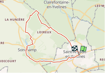
Trail On foot of 16.5 km to be discovered at Ile-de-France, Yvelines, Saint-Arnoult-en-Yvelines. This trail is proposed by ghislainem.
Description
Château de Pinceloup
Sonchamp: église 11ème
Vallée de la Rémarde
Moulin de Villeneuve (maison d'elsa Triolet et Aragon)
St Arnoult: église 11ème, maisons anciennes
Positioning
Country:
France
Region :
Ile-de-France
Department/Province :
Yvelines
Municipality :
Saint-Arnoult-en-Yvelines
Location:
Unknown
Start:(Dec)
Start:(UTM)
421809 ; 5380390 (31U) N.
Comments
Trails nearby
![Trail Walking Longvilliers - _Les Moulins de la Rémarde - Photo](https://media.geolcdn.com/t/375/260/ext.jpg?maxdim=2&url=https%3A%2F%2Fservices.sitytrail.com%2FGeolivesWS%2FDownloadMedia.ashx%3FTrailID%3D172068%26Media%3Db1cdb090-96c0-44bf-89a1-996bab033954.jpg)
![Walking Walking](https://static1.geolcdn.com/sitytour/trail-icons/101.png)
_Les Moulins de la Rémarde
Walking
Easy
(8)
Longvilliers,
Ile-de-France,
Yvelines,
France
![](/images/other/stat-length.png)
9.3 km | 10.4 km-effort
2h 0min
![](https://static1.geolcdn.com/siteimages/upload/files/16400158638029165_repeat_loop_refresh_sync_direction_icon.png)
Yes
![Trail Walking Clairefontaine-en-Yvelines - _Aux sources de la Rabette - Photo](https://media.geolcdn.com/t/375/260/ext.jpg?maxdim=2&url=https%3A%2F%2Fservices.sitytrail.com%2FGeolivesWS%2FDownloadMedia.ashx%3FTrailID%3D172067%26Media%3D8303e7f0-43e7-437e-9972-9962d4dcef0e.jpg)
![Walking Walking](https://static1.geolcdn.com/sitytour/trail-icons/101.png)
_Aux sources de la Rabette
Walking
Easy
(15)
Clairefontaine-en-Yvelines,
Ile-de-France,
Yvelines,
France
![](/images/other/stat-length.png)
7.2 km | 8.3 km-effort
1h 51min
![](https://static1.geolcdn.com/siteimages/upload/files/16400158638029165_repeat_loop_refresh_sync_direction_icon.png)
Yes
![Trail On foot Sainte-Mesme - Boucle en forêt de Dourdan au départ de Sainte Mesme - Photo](https://media.geolcdn.com/t/375/260/991a29e9-cb59-4be9-8562-0b553941774b.jpg&format=jpg&maxdim=2)
![On foot On foot](https://static1.geolcdn.com/sitytour/trail-icons/100.png)
Boucle en forêt de Dourdan au départ de Sainte Mesme
On foot
Easy
Sainte-Mesme,
Ile-de-France,
Yvelines,
France
![](/images/other/stat-length.png)
21 km | 25 km-effort
5h 43min
![](https://static1.geolcdn.com/siteimages/upload/files/16400158638029165_repeat_loop_refresh_sync_direction_icon.png)
Yes
![Trail On foot Dourdan - Promenade de Nemours - Photo](https://media.geolcdn.com/t/375/260/0b265bef-bfde-43df-b5d7-8e18dc6cd16f.jpeg&format=jpg&maxdim=2)
![On foot On foot](https://static1.geolcdn.com/sitytour/trail-icons/100.png)
Promenade de Nemours
On foot
Easy
Dourdan,
Ile-de-France,
Essonne,
France
![](/images/other/stat-length.png)
4.5 km | 4.9 km-effort
1h 6min
![](https://static1.geolcdn.com/siteimages/upload/files/16400158638029165_repeat_loop_refresh_sync_direction_icon.png)
No
![Trail Walking Sonchamp - _Sonchamp, entre ruelles, étang et forêt - Photo](https://media.geolcdn.com/t/375/260/ext.jpg?maxdim=2&url=https%3A%2F%2Fservices.sitytrail.com%2FGeolivesWS%2FDownloadMedia.ashx%3FTrailID%3D793359%26Media%3Da7fdaaed-ef91-44f6-b9b8-e931274307db.JPG)
![Walking Walking](https://static1.geolcdn.com/sitytour/trail-icons/101.png)
_Sonchamp, entre ruelles, étang et forêt
Walking
Medium
Sonchamp,
Ile-de-France,
Yvelines,
France
![](/images/other/stat-length.png)
8.9 km | 10.1 km-effort
2h 30min
![](https://static1.geolcdn.com/siteimages/upload/files/16400158638029165_repeat_loop_refresh_sync_direction_icon.png)
Yes
![Trail Walking Sonchamp - _La marlotterie - Photo](https://media.geolcdn.com/t/375/260/ext.jpg?maxdim=2&url=https%3A%2F%2Fservices.sitytrail.com%2FGeolivesWS%2FDownloadMedia.ashx%3FTrailID%3D780610%26Media%3D9a2ac7f9-d16a-44b5-b35a-b5d44d659c80.jpg)
![Walking Walking](https://static1.geolcdn.com/sitytour/trail-icons/101.png)
_La marlotterie
Walking
Easy
Sonchamp,
Ile-de-France,
Yvelines,
France
![](/images/other/stat-length.png)
5.9 km | 6.8 km-effort
1h 30min
![](https://static1.geolcdn.com/siteimages/upload/files/16400158638029165_repeat_loop_refresh_sync_direction_icon.png)
Yes
![Trail Walking Sonchamp - Sonchamps-Lorieux - Photo](https://media.geolcdn.com/t/375/260/ext.jpg?maxdim=2&url=https%3A%2F%2Fstatic1.geolcdn.com%2Fsiteimages%2Fupload%2Ffiles%2F1553511878bg_sport_marche.png)
![Walking Walking](https://static1.geolcdn.com/sitytour/trail-icons/101.png)
Sonchamps-Lorieux
Walking
Difficult
(1)
Sonchamp,
Ile-de-France,
Yvelines,
France
![](/images/other/stat-length.png)
11 km | 12.5 km-effort
2h 45min
![](https://static1.geolcdn.com/siteimages/upload/files/16400158638029165_repeat_loop_refresh_sync_direction_icon.png)
Yes
![Trail Nordic walking Dourdan - Forêt de Saint Arnoult - Photo](https://media.geolcdn.com/t/375/260/ext.jpg?maxdim=2&url=https%3A%2F%2Fstatic1.geolcdn.com%2Fsiteimages%2Fupload%2Ffiles%2F1545311037marcheuse_200dpi.jpg)
![Nordic walking Nordic walking](https://static1.geolcdn.com/sitytour/trail-icons/102.png)
Forêt de Saint Arnoult
Nordic walking
Easy
(1)
Dourdan,
Ile-de-France,
Essonne,
France
![](/images/other/stat-length.png)
8.6 km | 10.5 km-effort
1h 50min
![](https://static1.geolcdn.com/siteimages/upload/files/16400158638029165_repeat_loop_refresh_sync_direction_icon.png)
Yes
![Trail Walking Dourdan - Ste Mesme St Martin de Brethencourt - Photo](https://media.geolcdn.com/t/375/260/ext.jpg?maxdim=2&url=https%3A%2F%2Fstatic1.geolcdn.com%2Fsiteimages%2Fupload%2Ffiles%2F1553511878bg_sport_marche.png)
![Walking Walking](https://static1.geolcdn.com/sitytour/trail-icons/101.png)
Ste Mesme St Martin de Brethencourt
Walking
Medium
(2)
Dourdan,
Ile-de-France,
Essonne,
France
![](/images/other/stat-length.png)
14.9 km | 17.5 km-effort
5min
![](https://static1.geolcdn.com/siteimages/upload/files/16400158638029165_repeat_loop_refresh_sync_direction_icon.png)
Yes