![](/images/other/stat-length.png)
![Trail Walking Virieu-le-Grand - virieu - Cascades de Dard - Photo](https://media.geolcdn.com/t/1900/400/6cf5f770-e354-4589-b527-8e016bcd4eb8.jpg&format=pjpeg&maxdim=2)
virieu - Cascades de Dard
aurel69
User
![Length](/images/other/stat-length.png)
Length
9.2 km
![Max alt](https://static1.geolcdn.com/siteimages/upload/files/1508320355ic_sort_altitude_max_24dp.png)
Max alt
370 m
![Uphill gradient](https://static1.geolcdn.com/siteimages/upload/files/1508320355ic_sort_den_pos_24dp.png)
Uphill gradient
201 m
![Km-Effort](/images/other/stat-length.png)
Km-Effort
11.9 km
![Min alt](https://static1.geolcdn.com/siteimages/upload/files/1508320355ic_sort_altitude_min_24dp.png)
Min alt
252 m
![Downhill gradient](https://static1.geolcdn.com/siteimages/upload/files/1508320355ic_sort_den_neg_24dp.png)
Downhill gradient
205 m
![Boucle](https://static1.geolcdn.com/siteimages/upload/files/16400158638029165_repeat_loop_refresh_sync_direction_icon.png)
Boucle
Yes
Creation date :
2023-03-19 08:57:34.524
Updated on :
2023-03-19 12:52:41.985
![Walking](https://static1.geolcdn.com/sitytour/trail-icons/101.png)
3h53
Difficulty : Medium
![Scan this QR Code to open this trail in the SityTrail application](https://capi.geolives.com/qq0zvz2zws4bq2lad0pu/sitytour/trails/3590165/qr.png?size=200)
FREE GPS app for hiking
About
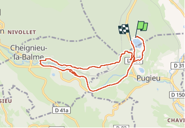
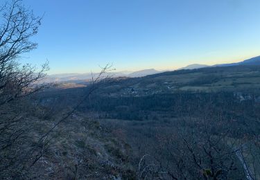
Trail Walking of 9.2 km to be discovered at Auvergne-Rhône-Alpes, Ain, Virieu-le-Grand. This trail is proposed by aurel69.
Description
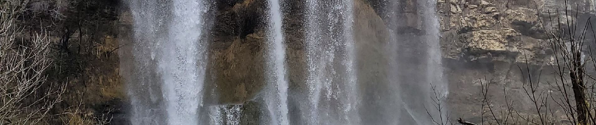
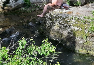
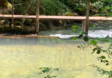
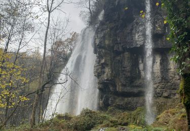
petite rando au départ du lac de Virieu pour découvrir les cascades de Dard.
attention la fin est sur le bord de la route
Positioning
Country:
France
Region :
Auvergne-Rhône-Alpes
Department/Province :
Ain
Municipality :
Virieu-le-Grand
Location:
Unknown
Start:(Dec)
Start:(UTM)
705251 ; 5078545 (31T) N.
Comments
Trails nearby
![Trail Mountain bike Cuzieu - Chazey-Bons/ Vongnes - Photo](https://media.geolcdn.com/t/375/260/ext.jpg?maxdim=2&url=https%3A%2F%2Fstatic1.geolcdn.com%2Fsiteimages%2Fupload%2Ffiles%2F1524743154velo.jpg)
![Mountain bike Mountain bike](https://static1.geolcdn.com/sitytour/trail-icons/202.png)
Chazey-Bons/ Vongnes
Mountain bike
Medium
(1)
Cuzieu,
Auvergne-Rhône-Alpes,
Ain,
France
![](/images/other/stat-length.png)
16.4 km | 21 km-effort
2h 5min
![](https://static1.geolcdn.com/siteimages/upload/files/16400158638029165_repeat_loop_refresh_sync_direction_icon.png)
Yes
![Trail Mountain bike Andert-et-Condon - Boucle sous Gevrin - Photo](https://media.geolcdn.com/t/375/260/ext.jpg?maxdim=2&url=https%3A%2F%2Fstatic1.geolcdn.com%2Fsiteimages%2Fupload%2Ffiles%2F1524743154velo.jpg)
![Mountain bike Mountain bike](https://static1.geolcdn.com/sitytour/trail-icons/202.png)
Boucle sous Gevrin
Mountain bike
Easy
(1)
Andert-et-Condon,
Auvergne-Rhône-Alpes,
Ain,
France
![](/images/other/stat-length.png)
13.1 km | 17.1 km-effort
1h 1min
![](https://static1.geolcdn.com/siteimages/upload/files/16400158638029165_repeat_loop_refresh_sync_direction_icon.png)
Yes
![Trail Walking Artemare - cascade de cerveyrieu - Photo](https://media.geolcdn.com/t/375/260/1fba5c6d-151e-4091-a127-1969b57d4eed.jpg&format=jpg&maxdim=2)
![Walking Walking](https://static1.geolcdn.com/sitytour/trail-icons/101.png)
cascade de cerveyrieu
Walking
Easy
Artemare,
Auvergne-Rhône-Alpes,
Ain,
France
![](/images/other/stat-length.png)
13.4 km | 19.1 km-effort
5h 27min
![](https://static1.geolcdn.com/siteimages/upload/files/16400158638029165_repeat_loop_refresh_sync_direction_icon.png)
Yes
![Trail Mountain bike Armix - armix-hostiaz - Photo](https://media.geolcdn.com/t/375/260/ext.jpg?maxdim=2&url=https%3A%2F%2Fservices.sitytrail.com%2FGeolivesWS%2FDownloadMedia.ashx%3FTrailID%3D814754%26Media%3Dfix__20170821161253.jpg)
![Mountain bike Mountain bike](https://static1.geolcdn.com/sitytour/trail-icons/202.png)
armix-hostiaz
Mountain bike
Difficult
Armix,
Auvergne-Rhône-Alpes,
Ain,
France
![](/images/other/stat-length.png)
31 km | 44 km-effort
2h 45min
![](https://static1.geolcdn.com/siteimages/upload/files/16400158638029165_repeat_loop_refresh_sync_direction_icon.png)
Yes
![Trail Mountain bike Andert-et-Condon - Recherche suite chemin du dimanche vers Gramont - Photo](https://media.geolcdn.com/t/375/260/d41da1d3-b810-4024-b7a2-cd2c7e0101ba.jpg&format=jpg&maxdim=2)
![Mountain bike Mountain bike](https://static1.geolcdn.com/sitytour/trail-icons/202.png)
Recherche suite chemin du dimanche vers Gramont
Mountain bike
Very difficult
Andert-et-Condon,
Auvergne-Rhône-Alpes,
Ain,
France
![](/images/other/stat-length.png)
11.6 km | 16.6 km-effort
1h 7min
![](https://static1.geolcdn.com/siteimages/upload/files/16400158638029165_repeat_loop_refresh_sync_direction_icon.png)
Yes
![Trail Mountain bike Andert-et-Condon - Sous Gevrin et Veript - Photo](https://media.geolcdn.com/t/375/260/4d4e91d3-2188-41e8-88ef-ba46cc370e52.jpg&format=jpg&maxdim=2)
![Mountain bike Mountain bike](https://static1.geolcdn.com/sitytour/trail-icons/202.png)
Sous Gevrin et Veript
Mountain bike
Medium
Andert-et-Condon,
Auvergne-Rhône-Alpes,
Ain,
France
![](/images/other/stat-length.png)
16.7 km | 22 km-effort
1h 28min
![](https://static1.geolcdn.com/siteimages/upload/files/16400158638029165_repeat_loop_refresh_sync_direction_icon.png)
No
![Trail Walking Cheignieu-la-Balme - cascade de DARD - Photo](https://media.geolcdn.com/t/375/260/9ead54f0-e619-48e4-af16-cbea0eb6a317.jpg&format=jpg&maxdim=2)
![Walking Walking](https://static1.geolcdn.com/sitytour/trail-icons/101.png)
cascade de DARD
Walking
Very easy
Cheignieu-la-Balme,
Auvergne-Rhône-Alpes,
Ain,
France
![](/images/other/stat-length.png)
25 km | 34 km-effort
1h 32min
![](https://static1.geolcdn.com/siteimages/upload/files/16400158638029165_repeat_loop_refresh_sync_direction_icon.png)
No
![Trail Mountain bike Andert-et-Condon - Tour 4 - Photo](https://media.geolcdn.com/t/375/260/5962a690-6b6c-4a8d-80ae-f0e2f032ab55.jpg&format=jpg&maxdim=2)
![Mountain bike Mountain bike](https://static1.geolcdn.com/sitytour/trail-icons/202.png)
Tour 4
Mountain bike
Medium
Andert-et-Condon,
Auvergne-Rhône-Alpes,
Ain,
France
![](/images/other/stat-length.png)
12.6 km | 16.4 km-effort
1h 6min
![](https://static1.geolcdn.com/siteimages/upload/files/16400158638029165_repeat_loop_refresh_sync_direction_icon.png)
Yes
![Trail Mountain bike Andert-et-Condon - Petite sortie vers Sainte Anne - Photo](https://media.geolcdn.com/t/375/260/cad95e1b-0d39-479c-90f6-a86e3dc264b0.jpg&format=jpg&maxdim=2)
![Mountain bike Mountain bike](https://static1.geolcdn.com/sitytour/trail-icons/202.png)
Petite sortie vers Sainte Anne
Mountain bike
Difficult
Andert-et-Condon,
Auvergne-Rhône-Alpes,
Ain,
France
![](/images/other/stat-length.png)
19.4 km | 26 km-effort
2h 50min
![](https://static1.geolcdn.com/siteimages/upload/files/16400158638029165_repeat_loop_refresh_sync_direction_icon.png)
Yes
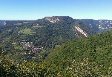
super randonnée...vue d'en haut de la cascade et vue d en bas à couper le souffle..pour finir au lac Virieu pause piknik