![](/images/other/stat-length.png)
![Trail Running Lille - Parcours du Semi-Marathon de Lille - Photo](https://media.geolcdn.com/t/1900/400/ext.pjpeg?maxdim=2&url=https%3A%2F%2Fstatic1.geolcdn.com%2Fsiteimages%2Fupload%2Ffiles%2F1524743154running.jpg)
Parcours du Semi-Marathon de Lille
Greg813
User
![Length](/images/other/stat-length.png)
Length
12.3 km
![Max alt](https://static1.geolcdn.com/siteimages/upload/files/1508320355ic_sort_altitude_max_24dp.png)
Max alt
39 m
![Uphill gradient](https://static1.geolcdn.com/siteimages/upload/files/1508320355ic_sort_den_pos_24dp.png)
Uphill gradient
99 m
![Km-Effort](/images/other/stat-length.png)
Km-Effort
13.6 km
![Min alt](https://static1.geolcdn.com/siteimages/upload/files/1508320355ic_sort_altitude_min_24dp.png)
Min alt
14 m
![Downhill gradient](https://static1.geolcdn.com/siteimages/upload/files/1508320355ic_sort_den_neg_24dp.png)
Downhill gradient
100 m
![Boucle](https://static1.geolcdn.com/siteimages/upload/files/16400158638029165_repeat_loop_refresh_sync_direction_icon.png)
Boucle
Yes
Creation date :
2023-03-19 07:24:56.94
Updated on :
2023-03-19 07:28:49.981
![Running](https://static1.geolcdn.com/sitytour/trail-icons/103.png)
1h00
Difficulty : Medium
![Scan this QR Code to open this trail in the SityTrail application](https://capi.geolives.com/qq0zvz2zws4bq2lad0pu/sitytour/trails/3589703/qr.png?size=200)
FREE GPS app for hiking
About
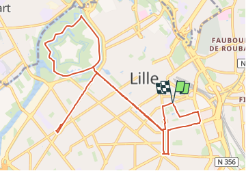
Trail Running of 12.3 km to be discovered at Hauts-de-France, Nord, Lille. This trail is proposed by Greg813.
Description
Boucle de 12 km réalisé sur le parcours du semi-marathon de Lille.
A partir de 07h le matin, les rues sont déjà barrées et il n'y a personne, au top !
Positioning
Country:
France
Region :
Hauts-de-France
Department/Province :
Nord
Municipality :
Lille
Location:
Lille
Start:(Dec)
Start:(UTM)
505010 ; 5608970 (31U) N.
Comments
Trails nearby
![Trail Walking Lille - Autour de la citadelle - Photo](https://media.geolcdn.com/t/375/260/ext.jpg?maxdim=2&url=https%3A%2F%2Fservices.sitytrail.com%2FGeolivesWS%2FDownloadMedia.ashx%3FTrailID%3D202857%26Media%3Dcd62111c-4a73-449f-8a35-c1f82fa269d1.jpg)
![Walking Walking](https://static1.geolcdn.com/sitytour/trail-icons/101.png)
Autour de la citadelle
Walking
Very easy
(2)
Lille,
Hauts-de-France,
Nord,
France
![](/images/other/stat-length.png)
5.5 km | 6.1 km-effort
Unknown
![](https://static1.geolcdn.com/siteimages/upload/files/16400158638029165_repeat_loop_refresh_sync_direction_icon.png)
Yes
![Trail Mountain bike Villeneuve-d'Ascq - Le tour des lacs - Villeneuve d'Ascq. - Photo](https://media.geolcdn.com/t/375/260/ext.jpg?maxdim=2&url=https%3A%2F%2Fservices.sitytrail.com%2FGeolivesWS%2FDownloadMedia.ashx%3FTrailID%3D112626%26Media%3D11224_6.jpg)
![Mountain bike Mountain bike](https://static1.geolcdn.com/sitytour/trail-icons/202.png)
Le tour des lacs - Villeneuve d'Ascq.
Mountain bike
Easy
(1)
Villeneuve-d'Ascq,
Hauts-de-France,
Nord,
France
![](/images/other/stat-length.png)
16.1 km | 17.3 km-effort
1h 30min
![](https://static1.geolcdn.com/siteimages/upload/files/16400158638029165_repeat_loop_refresh_sync_direction_icon.png)
Yes
![Trail Walking Lille - Autour de la citadelle de Lille - Photo](https://media.geolcdn.com/t/375/260/ext.jpg?maxdim=2&url=https%3A%2F%2Fservices.sitytrail.com%2FGeolivesWS%2FDownloadMedia.ashx%3FTrailID%3D109754%26Media%3D4580_6.jpg)
![Walking Walking](https://static1.geolcdn.com/sitytour/trail-icons/101.png)
Autour de la citadelle de Lille
Walking
Easy
(2)
Lille,
Hauts-de-France,
Nord,
France
![](/images/other/stat-length.png)
5.6 km | 6.3 km-effort
1h 30min
![](https://static1.geolcdn.com/siteimages/upload/files/16400158638029165_repeat_loop_refresh_sync_direction_icon.png)
Yes
![Walking Walking](https://static1.geolcdn.com/sitytour/trail-icons/101.png)
20230918 - TOTEMUS Lille - 5.4 Km
Walking
Easy
Lille,
Hauts-de-France,
Nord,
France
![](/images/other/stat-length.png)
5.4 km | 5.8 km-effort
1h 28min
![](https://static1.geolcdn.com/siteimages/upload/files/16400158638029165_repeat_loop_refresh_sync_direction_icon.png)
Yes
![Trail Walking Lille - LILLE (court) - de la gare L. Flandres au Minimes - Photo](https://media.geolcdn.com/t/375/260/ext.jpg?maxdim=2&url=https%3A%2F%2Fstatic1.geolcdn.com%2Fsiteimages%2Fupload%2Ffiles%2F1553511878bg_sport_marche.png)
![Walking Walking](https://static1.geolcdn.com/sitytour/trail-icons/101.png)
LILLE (court) - de la gare L. Flandres au Minimes
Walking
Easy
(1)
Lille,
Hauts-de-France,
Nord,
France
![](/images/other/stat-length.png)
4.1 km | 4.6 km-effort
1h 2min
![](https://static1.geolcdn.com/siteimages/upload/files/16400158638029165_repeat_loop_refresh_sync_direction_icon.png)
Yes
![Trail Walking Lille - Lille rando des remparts 18 km - Photo](https://media.geolcdn.com/t/375/260/47f3105d-7eb3-4eed-9a9d-96927ffd6f80.jpg&format=jpg&maxdim=2)
![Walking Walking](https://static1.geolcdn.com/sitytour/trail-icons/101.png)
Lille rando des remparts 18 km
Walking
Medium
Lille,
Hauts-de-France,
Nord,
France
![](/images/other/stat-length.png)
20 km | 0 m-effort
5h 37min
![](https://static1.geolcdn.com/siteimages/upload/files/16400158638029165_repeat_loop_refresh_sync_direction_icon.png)
Yes
![Trail Mountain bike Lambersart - Deûle et ses campagnes - Photo](https://media.geolcdn.com/t/375/260/ext.jpg?maxdim=2&url=https%3A%2F%2Fstatic1.geolcdn.com%2Fsiteimages%2Fupload%2Ffiles%2F1524743154velo.jpg)
![Mountain bike Mountain bike](https://static1.geolcdn.com/sitytour/trail-icons/202.png)
Deûle et ses campagnes
Mountain bike
Easy
(2)
Lambersart,
Hauts-de-France,
Nord,
France
![](/images/other/stat-length.png)
24 km | 25 km-effort
1h 25min
![](https://static1.geolcdn.com/siteimages/upload/files/16400158638029165_repeat_loop_refresh_sync_direction_icon.png)
Yes
![Trail Walking Lille - Lille Citadelle - Lion bossu 5,4 km - Photo](https://media.geolcdn.com/t/375/260/cac3c5ee-efcd-4c5f-8540-f45174e54dca.jpg&format=jpg&maxdim=2)
![Walking Walking](https://static1.geolcdn.com/sitytour/trail-icons/101.png)
Lille Citadelle - Lion bossu 5,4 km
Walking
Easy
Lille,
Hauts-de-France,
Nord,
France
![](/images/other/stat-length.png)
5.4 km | 6 km-effort
1h 53min
![](https://static1.geolcdn.com/siteimages/upload/files/16400158638029165_repeat_loop_refresh_sync_direction_icon.png)
No
![Trail Walking Lille - Lille 9,5 km - Photo](https://media.geolcdn.com/t/375/260/4613ef8f-7f8a-43c2-950f-fd137ced6f10.jpg&format=jpg&maxdim=2)
![Walking Walking](https://static1.geolcdn.com/sitytour/trail-icons/101.png)
Lille 9,5 km
Walking
Easy
Lille,
Hauts-de-France,
Nord,
France
![](/images/other/stat-length.png)
10.3 km | 11.3 km-effort
4h 24min
![](https://static1.geolcdn.com/siteimages/upload/files/16400158638029165_repeat_loop_refresh_sync_direction_icon.png)
Yes
Quel beau parcours pour le Semi-Marathon de Lille ! En tant que coureur lillois, je suis ravi de découvrir ce tracé qui met en valeur les plus beaux quartiers et monuments de la ville. Le départ Boulevard Louis XIV est idéalement situé, face à la magnifique Maison Georges Lefebvre. C'est une entrée en matière parfaite pour cette course emblématique. J'apprécie particulièrement le passage par la Citadelle entre les km 3 et 5. Courir dans ce vaste parc verdoyant en plein cœur de Lille est toujours un vrai plaisir. Le parcours longe le canal de la Deûle, ce qui promet des paysages bucoliques pour se ressourcer. Il y a tellement de spots géniaux pour courir à Lille : https://athleexplique.fr/ou-courir-a-lille-top-10-des-meilleurs-endroits/