![](/images/other/stat-length.png)
![Trail Mountain bike Sainte-Marie-sur-Ouche - Ste Marie st Jean de Boeuf Antheuil Retour Canal - Photo](https://media.geolcdn.com/t/1900/400/ext.pjpeg?maxdim=2&url=https%3A%2F%2Fstatic1.geolcdn.com%2Fsiteimages%2Fupload%2Ffiles%2F1524743154velo.jpg)
Ste Marie st Jean de Boeuf Antheuil Retour Canal
mricard
User
![Length](/images/other/stat-length.png)
Length
40 km
![Max alt](https://static1.geolcdn.com/siteimages/upload/files/1508320355ic_sort_altitude_max_24dp.png)
Max alt
632 m
![Uphill gradient](https://static1.geolcdn.com/siteimages/upload/files/1508320355ic_sort_den_pos_24dp.png)
Uphill gradient
640 m
![Km-Effort](/images/other/stat-length.png)
Km-Effort
48 km
![Min alt](https://static1.geolcdn.com/siteimages/upload/files/1508320355ic_sort_altitude_min_24dp.png)
Min alt
282 m
![Downhill gradient](https://static1.geolcdn.com/siteimages/upload/files/1508320355ic_sort_den_neg_24dp.png)
Downhill gradient
640 m
![Boucle](https://static1.geolcdn.com/siteimages/upload/files/16400158638029165_repeat_loop_refresh_sync_direction_icon.png)
Boucle
Yes
Creation date :
2023-03-16 13:56:45.919
Updated on :
2023-03-16 13:59:25.941
![Mountain bike](https://static1.geolcdn.com/sitytour/trail-icons/202.png)
3h55
Difficulty : Medium
![Scan this QR Code to open this trail in the SityTrail application](https://capi.geolives.com/qq0zvz2zws4bq2lad0pu/sitytour/trails/3586960/qr.png?size=200)
FREE GPS app for hiking
About
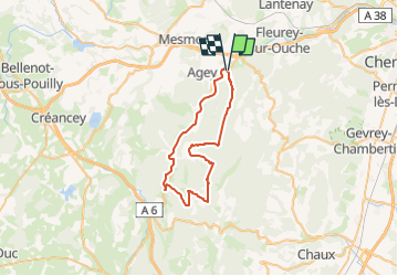
Trail Mountain bike of 40 km to be discovered at Bourgogne-Franche-Comté, Côte-d'Or, Sainte-Marie-sur-Ouche. This trail is proposed by mricard.
Description
Une quarantaine de kilomètres en vélo. Chemins blancs en forêt avec quelques dénivelés, puis un retour tranquille par le chemin de halage.
Positioning
Country:
France
Region :
Bourgogne-Franche-Comté
Department/Province :
Côte-d'Or
Municipality :
Sainte-Marie-sur-Ouche
Location:
Unknown
Start:(Dec)
Start:(UTM)
635732 ; 5238527 (31T) N.
Comments
Trails nearby
![Trail Walking Sainte-Marie-sur-Ouche - Pont de Pany - Photo](https://media.geolcdn.com/t/375/260/880c73c5-f480-4d0e-b6d7-7819f4768403.jpg&format=jpg&maxdim=2)
![Walking Walking](https://static1.geolcdn.com/sitytour/trail-icons/101.png)
Pont de Pany
Walking
Easy
(1)
Sainte-Marie-sur-Ouche,
Bourgogne-Franche-Comté,
Côte-d'Or,
France
![](/images/other/stat-length.png)
11.4 km | 16 km-effort
3h 19min
![](https://static1.geolcdn.com/siteimages/upload/files/16400158638029165_repeat_loop_refresh_sync_direction_icon.png)
Yes
![Trail Walking Urcy - Les environs d'Urcy - Photo](https://media.geolcdn.com/t/375/260/ext.jpg?maxdim=2&url=https%3A%2F%2Fservices.sitytrail.com%2FGeolivesWS%2FDownloadMedia.ashx%3FTrailID%3D104689%26Media%3D8092_1.jpg)
![Walking Walking](https://static1.geolcdn.com/sitytour/trail-icons/101.png)
Les environs d'Urcy
Walking
Difficult
(2)
Urcy,
Bourgogne-Franche-Comté,
Côte-d'Or,
France
![](/images/other/stat-length.png)
18.9 km | 27 km-effort
6h 0min
![](https://static1.geolcdn.com/siteimages/upload/files/16400158638029165_repeat_loop_refresh_sync_direction_icon.png)
No
![Trail Walking Barbirey-sur-Ouche - Le Tour de Barbiriacum - Barbirey sur Ouche - Photo](https://media.geolcdn.com/t/375/260/ext.jpg?maxdim=2&url=https%3A%2F%2Fservices.sitytrail.com%2FGeolivesWS%2FDownloadMedia.ashx%3FTrailID%3D104688%26Media%3D8091_1.jpg)
![Walking Walking](https://static1.geolcdn.com/sitytour/trail-icons/101.png)
Le Tour de Barbiriacum - Barbirey sur Ouche
Walking
Medium
(1)
Barbirey-sur-Ouche,
Bourgogne-Franche-Comté,
Côte-d'Or,
France
![](/images/other/stat-length.png)
10.5 km | 15.9 km-effort
2h 45min
![](https://static1.geolcdn.com/siteimages/upload/files/16400158638029165_repeat_loop_refresh_sync_direction_icon.png)
Yes
![Trail Walking Sainte-Marie-sur-Ouche - Belvédères sur la vallée de l'Ouche - Pont de Pany - Photo](https://media.geolcdn.com/t/375/260/ext.jpg?maxdim=2&url=https%3A%2F%2Fservices.sitytrail.com%2FGeolivesWS%2FDownloadMedia.ashx%3FTrailID%3D104685%26Media%3D8088_1.jpg)
![Walking Walking](https://static1.geolcdn.com/sitytour/trail-icons/101.png)
Belvédères sur la vallée de l'Ouche - Pont de Pany
Walking
Difficult
(1)
Sainte-Marie-sur-Ouche,
Bourgogne-Franche-Comté,
Côte-d'Or,
France
![](/images/other/stat-length.png)
20 km | 28 km-effort
6h 0min
![](https://static1.geolcdn.com/siteimages/upload/files/16400158638029165_repeat_loop_refresh_sync_direction_icon.png)
Yes
![Trail Walking Mâlain - Mâlain - Charmoy - Baulme le Roche - Photo](https://media.geolcdn.com/t/375/260/ext.jpg?maxdim=2&url=https%3A%2F%2Fservices.sitytrail.com%2FGeolivesWS%2FDownloadMedia.ashx%3FTrailID%3D104684%26Media%3D8087_1.jpg)
![Walking Walking](https://static1.geolcdn.com/sitytour/trail-icons/101.png)
Mâlain - Charmoy - Baulme le Roche
Walking
Medium
(3)
Mâlain,
Bourgogne-Franche-Comté,
Côte-d'Or,
France
![](/images/other/stat-length.png)
15.3 km | 21 km-effort
3h 30min
![](https://static1.geolcdn.com/siteimages/upload/files/16400158638029165_repeat_loop_refresh_sync_direction_icon.png)
Yes
![Trail Walking Fleurey-sur-Ouche - Le Marathon de Fleurey sur Ouche - Photo](https://media.geolcdn.com/t/375/260/ext.jpg?maxdim=2&url=https%3A%2F%2Fservices.sitytrail.com%2FGeolivesWS%2FDownloadMedia.ashx%3FTrailID%3D104675%26Media%3D8078_1.jpg)
![Walking Walking](https://static1.geolcdn.com/sitytour/trail-icons/101.png)
Le Marathon de Fleurey sur Ouche
Walking
Very difficult
(1)
Fleurey-sur-Ouche,
Bourgogne-Franche-Comté,
Côte-d'Or,
France
![](/images/other/stat-length.png)
40 km | 54 km-effort
10h 0min
![](https://static1.geolcdn.com/siteimages/upload/files/16400158638029165_repeat_loop_refresh_sync_direction_icon.png)
Yes
![Trail Electric bike Sainte-Marie-sur-Ouche - Canal de Bourgogne_Etape 6 - Photo](https://media.geolcdn.com/t/375/260/ext.jpg?maxdim=2&url=https%3A%2F%2Fstatic1.geolcdn.com%2Fsiteimages%2Fupload%2Ffiles%2F1524743154velo.jpg)
![Electric bike Electric bike](https://static1.geolcdn.com/sitytour/trail-icons/205.png)
Canal de Bourgogne_Etape 6
Electric bike
Very easy
(1)
Sainte-Marie-sur-Ouche,
Bourgogne-Franche-Comté,
Côte-d'Or,
France
![](/images/other/stat-length.png)
22 km | 23 km-effort
Unknown
![](https://static1.geolcdn.com/siteimages/upload/files/16400158638029165_repeat_loop_refresh_sync_direction_icon.png)
No
![Trail On foot Mâlain - Sentier du Mâlain - Photo](https://media.geolcdn.com/t/375/260/ac839600-ec98-4d3e-b54d-0b1e7cde5571.jpeg&format=jpg&maxdim=2)
![On foot On foot](https://static1.geolcdn.com/sitytour/trail-icons/100.png)
Sentier du Mâlain
On foot
Easy
Mâlain,
Bourgogne-Franche-Comté,
Côte-d'Or,
France
![](/images/other/stat-length.png)
6.6 km | 10.5 km-effort
2h 22min
![](https://static1.geolcdn.com/siteimages/upload/files/16400158638029165_repeat_loop_refresh_sync_direction_icon.png)
Yes
![Trail On foot Fleurey-sur-Ouche - Sentier des Roches d'Orgères - Photo](https://media.geolcdn.com/t/375/260/22d3f48c-a3a5-4f31-ac6b-414d68092044.jpeg&format=jpg&maxdim=2)
![On foot On foot](https://static1.geolcdn.com/sitytour/trail-icons/100.png)
Sentier des Roches d'Orgères
On foot
Easy
Fleurey-sur-Ouche,
Bourgogne-Franche-Comté,
Côte-d'Or,
France
![](/images/other/stat-length.png)
4.2 km | 4.8 km-effort
1h 4min
![](https://static1.geolcdn.com/siteimages/upload/files/16400158638029165_repeat_loop_refresh_sync_direction_icon.png)
Yes