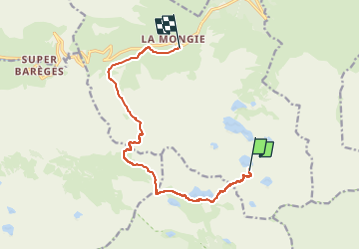
Trail Touring skiing Bagnères-de-Bigorre - Campana la Mongie crabe - Photo
 flau31
flau31

User

© OpenStreetMap contributors
Length
Length
11.8 km
Max alt
Max alt
2484 m
Uphill gradient
Uphill gradient
586 m
Km-Effort
Km-Effort  
21 km
Min alt
Min alt
1738 m
Downhill gradient
Downhill gradient
1115 m
Boucle
Boucle
No
Creation date :
2023-03-16 07:40:48.407
Updated on :
2023-03-16 12:11:46.786

(0 Reviews)

Touring skiing
Touring skiing
4h30
Difficulty : Very easy

Scan this QR Code to open this trail in the SityTrail application

FREE GPS app for hiking

Logo SityTrail SityTrail

IGN / Geographical institutes

Download SityTrail from the App Store Download SityTrail from Google Play

Logo SityTrail SityTrail World

The world is yours!

Download SityTrail from the App Store Download SityTrail from Google Play Download SityTrail on Huawei AppGallery

About

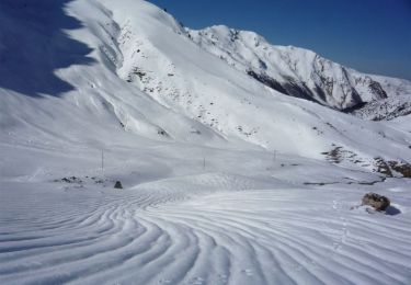
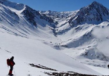
Trail Touring skiing of 11.8 km to be discovered at Occitania, Hautespyrenees, Bagnères-de-Bigorre. This trail is proposed by flau31.

Elevation profile

Positioning

Country:
France
Region :
Occitania
Department/Province :
Hautespyrenees
Municipality :
Bagnères-de-Bigorre
Location:
Unknown
Start:(UTM)
271656 ; 4751151 (31T) N.

Trails nearby

Trail Walking Vielle-Aure - Gourgue de Raba - Photo
Walking
sereton

Walking

Very easy
Vielle-Aure, Occitania, Hautespyrenees, France
4.4 km | 7.9 km-effort
1h 46min
Yes
Trail Walking Bagnères-de-Bigorre - tourmalet G2 heit  - Photo
Walking
LouisROGER

Walking

Very easy
Bagnères-de-Bigorre, Occitania, Hautespyrenees, France
5.5 km | 11.6 km-effort
6h 37min
Yes
Trail Walking Bagnères-de-Bigorre - Le pic du Midi de Bigorre - Photo
Walking
chasle

Walking

Difficult
Bagnères-de-Bigorre, Occitania, Hautespyrenees, France
13.4 km | 24 km-effort
3h 40min
Yes
Trail Walking Vielle-Aure - Madamète  - Photo
Walking
zazibelle

Walking

Medium
Vielle-Aure, Occitania, Hautespyrenees, France
10.3 km | 17.6 km-effort
5h 50min
Yes
Trail Snowshoes Bagnères-de-Bigorre - Le Lac de Caderolles - Artigues - Photo
Snowshoes
tracegps

Snowshoes

Difficult
Bagnères-de-Bigorre, Occitania, Hautespyrenees, France
8.2 km | 17.1 km-effort
6h 30min
Yes
Trail Snowshoes Bagnères-de-Bigorre - Crête des Cots - Artigues-Campan - Photo
Snowshoes
tracegps

Snowshoes

Difficult
Bagnères-de-Bigorre, Occitania, Hautespyrenees, France
6.8 km | 14.3 km-effort
5h 30min
Yes
Trail Walking Bagnères-de-Bigorre - Circuit des Lacs entre la Mongie et Barèges - 3 jours dans le Néouvielle - Photo
Walking
tracegps

Walking

Medium
Bagnères-de-Bigorre, Occitania, Hautespyrenees, France
31 km | 58 km-effort
78h 0min
No
Trail Walking Vielle-Aure - Col de Madamète - Photo
Walking
francois911

Walking

Medium
Vielle-Aure, Occitania, Hautespyrenees, France
11.3 km | 18.2 km-effort
3h 48min
No
Trail Walking Bagnères-de-Bigorre - Le pic du Midi de Bigorre - Photo
Walking
tracegps

Walking

Difficult
(2)
Bagnères-de-Bigorre, Occitania, Hautespyrenees, France
13.4 km | 24 km-effort
3h 40min
Yes


Close
My subscriptions