![](/images/other/stat-length.png)
![Trail Walking Sauvagnon - RS Sauvagnon plaine - Photo](https://media.geolcdn.com/t/1900/400/0353783e-128b-45a6-a961-fc352d3f6f09.jpg&format=pjpeg&maxdim=2)
RS Sauvagnon plaine
cromignon
User
![Length](/images/other/stat-length.png)
![Max alt](https://static1.geolcdn.com/siteimages/upload/files/1508320355ic_sort_altitude_max_24dp.png)
![Uphill gradient](https://static1.geolcdn.com/siteimages/upload/files/1508320355ic_sort_den_pos_24dp.png)
![Km-Effort](/images/other/stat-length.png)
![Min alt](https://static1.geolcdn.com/siteimages/upload/files/1508320355ic_sort_altitude_min_24dp.png)
![Downhill gradient](https://static1.geolcdn.com/siteimages/upload/files/1508320355ic_sort_den_neg_24dp.png)
![Boucle](https://static1.geolcdn.com/siteimages/upload/files/16400158638029165_repeat_loop_refresh_sync_direction_icon.png)
![Walking](https://static1.geolcdn.com/sitytour/trail-icons/101.png)
1h32
Difficulty : Medium
![Scan this QR Code to open this trail in the SityTrail application](https://capi.geolives.com/qq0zvz2zws4bq2lad0pu/sitytour/trails/3582340/qr.png?size=200)
FREE GPS app for hiking
About
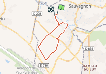
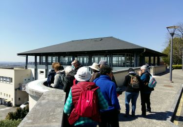
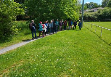
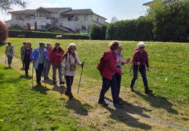
Trail Walking of 6.2 km to be discovered at New Aquitaine, Pyrénées-Atlantiques, Sauvagnon. This trail is proposed by cromignon.
Description
Promenade agréable, facile et campagnarde, mais un kilomètre trop long. Il faut laissé une voiture au borne 4.9km pour ramener certains promeneurs au départ, où se trouve un joli aire de PN. Balade à faire quand le mais n'est pas trop haut. Belle vue sur les Pyrénées et très peu de goudron.
Positioning
Comments
Trails nearby
![Trail Walking Uzein - RS Uzein](https://media.geolcdn.com/t/375/260/da0305da-d09c-49d9-8b52-f3d770fc1b4d.jpg&format=jpg&maxdim=2)
![Walking Walking](https://static1.geolcdn.com/sitytour/trail-icons/101.png)
Walking
![](/images/other/stat-length.png)
![](https://static1.geolcdn.com/siteimages/upload/files/16400158638029165_repeat_loop_refresh_sync_direction_icon.png)
![Trail Walking Montardon - MONTARDON RS Autour du Luy 3255249 - Photo](https://media.geolcdn.com/t/375/260/47e897ef-7a79-49c5-9ea1-c85bc310ec38.jpg&format=jpg&maxdim=2)
![Walking Walking](https://static1.geolcdn.com/sitytour/trail-icons/101.png)
Walking
![](/images/other/stat-length.png)
![](https://static1.geolcdn.com/siteimages/upload/files/16400158638029165_repeat_loop_refresh_sync_direction_icon.png)
![Trail Walking Serres-Castet - SERRES CASTET RS autour du lac - Photo](https://media.geolcdn.com/t/375/260/0287ff47-814b-4979-9fae-639cc528956d.jpg&format=jpg&maxdim=2)
![Walking Walking](https://static1.geolcdn.com/sitytour/trail-icons/101.png)
Walking
![](/images/other/stat-length.png)
![](https://static1.geolcdn.com/siteimages/upload/files/16400158638029165_repeat_loop_refresh_sync_direction_icon.png)
![Trail Walking Serres-Castet - Rs serrés castet 2024 - Photo](https://media.geolcdn.com/t/375/260/b1fe0341-67b4-4330-a058-ff164ab8dc9d.jpg&format=jpg&maxdim=2)
![Walking Walking](https://static1.geolcdn.com/sitytour/trail-icons/101.png)
Walking
![](/images/other/stat-length.png)
![](https://static1.geolcdn.com/siteimages/upload/files/16400158638029165_repeat_loop_refresh_sync_direction_icon.png)
![Trail Walking Serres-Castet - serrescastet RSFait - Photo](https://media.geolcdn.com/t/375/260/13292052-8a0a-4f58-af18-0d36afaca4d0.jpg&format=jpg&maxdim=2)
![Walking Walking](https://static1.geolcdn.com/sitytour/trail-icons/101.png)
Walking
![](/images/other/stat-length.png)
![](https://static1.geolcdn.com/siteimages/upload/files/16400158638029165_repeat_loop_refresh_sync_direction_icon.png)
![Trail Walking Serres-Castet - serres castet RS le lac 2023 - Photo](https://media.geolcdn.com/t/375/260/ext.jpg?maxdim=2&url=https%3A%2F%2Fstatic1.geolcdn.com%2Fsiteimages%2Fupload%2Ffiles%2F1553511878bg_sport_marche.png)
![Walking Walking](https://static1.geolcdn.com/sitytour/trail-icons/101.png)
Walking
![](/images/other/stat-length.png)
![](https://static1.geolcdn.com/siteimages/upload/files/16400158638029165_repeat_loop_refresh_sync_direction_icon.png)
![Trail Walking Caubios-Loos - 2022-06-13_21h45m40_SityTrail - 3181291 - caubios-loosxg4-xboucle--par-le-sanctuaire-de-sainte-quitteriex - Photo](https://media.geolcdn.com/t/375/260/ext.jpg?maxdim=2&url=https%3A%2F%2Fstatic1.geolcdn.com%2Fsiteimages%2Fupload%2Ffiles%2F1553511878bg_sport_marche.png)
![Walking Walking](https://static1.geolcdn.com/sitytour/trail-icons/101.png)
Walking
![](/images/other/stat-length.png)
![](https://static1.geolcdn.com/siteimages/upload/files/16400158638029165_repeat_loop_refresh_sync_direction_icon.png)
![Trail Mountain bike Serres-Castet - Serres Castet 2022 - 44Km - Photo](https://media.geolcdn.com/t/375/260/ext.jpg?maxdim=2&url=https%3A%2F%2Fstatic1.geolcdn.com%2Fsiteimages%2Fupload%2Ffiles%2F1524743154velo.jpg)
![Mountain bike Mountain bike](https://static1.geolcdn.com/sitytour/trail-icons/202.png)
Mountain bike
![](/images/other/stat-length.png)
![](https://static1.geolcdn.com/siteimages/upload/files/16400158638029165_repeat_loop_refresh_sync_direction_icon.png)
![Trail On foot Serres-Castet - SERRES CASTET essai numerisation avec May - Photo](https://media.geolcdn.com/t/375/260/3ed7bc43-76e5-4d50-86db-f06d750a31d9.jpg&format=jpg&maxdim=2)
![On foot On foot](https://static1.geolcdn.com/sitytour/trail-icons/100.png)
On foot
![](/images/other/stat-length.png)
![](https://static1.geolcdn.com/siteimages/upload/files/16400158638029165_repeat_loop_refresh_sync_direction_icon.png)