![](/images/other/stat-length.png)
![Trail Walking Mettet - METTET-PONTAURY _ Marche Fédérale _ NA _12/03/2023 - Photo](https://media.geolcdn.com/t/1900/400/71785a61-8f33-499e-9752-17341cbe4102.jpg&format=pjpeg&maxdim=2)
METTET-PONTAURY _ Marche Fédérale _ NA _12/03/2023
jeangulu
User
![Length](/images/other/stat-length.png)
Length
18 km
![Max alt](https://static1.geolcdn.com/siteimages/upload/files/1508320355ic_sort_altitude_max_24dp.png)
Max alt
287 m
![Uphill gradient](https://static1.geolcdn.com/siteimages/upload/files/1508320355ic_sort_den_pos_24dp.png)
Uphill gradient
243 m
![Km-Effort](/images/other/stat-length.png)
Km-Effort
21 km
![Min alt](https://static1.geolcdn.com/siteimages/upload/files/1508320355ic_sort_altitude_min_24dp.png)
Min alt
213 m
![Downhill gradient](https://static1.geolcdn.com/siteimages/upload/files/1508320355ic_sort_den_neg_24dp.png)
Downhill gradient
243 m
![Boucle](https://static1.geolcdn.com/siteimages/upload/files/16400158638029165_repeat_loop_refresh_sync_direction_icon.png)
Boucle
Yes
Creation date :
2023-03-12 09:21:47.319
Updated on :
2023-03-12 14:03:14.064
![Walking](https://static1.geolcdn.com/sitytour/trail-icons/101.png)
4h39
Difficulty : Medium
![Scan this QR Code to open this trail in the SityTrail application](https://capi.geolives.com/qq0zvz2zws4bq2lad0pu/sitytour/trails/3582104/qr.png?size=200)
FREE GPS app for hiking
About
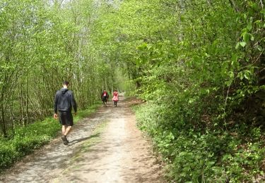
Trail Walking of 18 km to be discovered at Wallonia, Namur, Mettet. This trail is proposed by jeangulu.
Description
Point de départ : Salle G. Massinon _ Rue Félicien Rops. 30 - 5640 - METTET-PONTAURY.
Carte IGN : 53/2
Organisateur : NA 001 _ FOOTING CLUB FOSSES ASBL
Marche des Jonquilles
Positioning
Country:
Belgium
Region :
Wallonia
Department/Province :
Namur
Municipality :
Mettet
Location:
Unknown
Start:(Dec)
Start:(UTM)
618347 ; 5577635 (31U) N.
Comments
Trails nearby
![Walking Walking](https://static1.geolcdn.com/sitytour/trail-icons/101.png)
RB-Na-23-Sur le plateau de l’Entre-Sambre-et-Meuse
Walking
Very difficult
(8)
Mettet,
Wallonia,
Namur,
Belgium
![](/images/other/stat-length.png)
24 km | 29 km-effort
6h 39min
![](https://static1.geolcdn.com/siteimages/upload/files/16400158638029165_repeat_loop_refresh_sync_direction_icon.png)
Yes
![Trail Walking Fosses-la-Ville - Circuit de Belle Eau 2- - Photo](https://media.geolcdn.com/t/375/260/ext.jpg?maxdim=2&url=https%3A%2F%2Fservices.sitytrail.com%2FGeolivesWS%2FDownloadMedia.ashx%3FTrailID%3D402513%26Media%3D8f521a0c-a043-4094-8396-27fd749e1a3d.JPG)
![Walking Walking](https://static1.geolcdn.com/sitytour/trail-icons/101.png)
Circuit de Belle Eau 2-
Walking
Medium
(8)
Fosses-la-Ville,
Wallonia,
Namur,
Belgium
![](/images/other/stat-length.png)
12 km | 14.2 km-effort
3h 4min
![](https://static1.geolcdn.com/siteimages/upload/files/16400158638029165_repeat_loop_refresh_sync_direction_icon.png)
Yes
![Walking Walking](https://static1.geolcdn.com/sitytour/trail-icons/101.png)
RB-Na-23-racc-Sur le plateau de l’Entre-Sambre-et-Meuse
Walking
Difficult
(8)
Mettet,
Wallonia,
Namur,
Belgium
![](/images/other/stat-length.png)
14 km | 16.7 km-effort
3h 47min
![](https://static1.geolcdn.com/siteimages/upload/files/16400158638029165_repeat_loop_refresh_sync_direction_icon.png)
Yes
![Trail Walking Fosses-la-Ville - Balade à Sart-Eustache - Photo](https://media.geolcdn.com/t/375/260/ext.jpg?maxdim=2&url=https%3A%2F%2Fservices.sitytrail.com%2FGeolivesWS%2FDownloadMedia.ashx%3FTrailID%3D745477%26Media%3D0d9905aa-0e68-4255-ba20-1d4f668867f0.JPG)
![Walking Walking](https://static1.geolcdn.com/sitytour/trail-icons/101.png)
Balade à Sart-Eustache
Walking
Easy
(1)
Fosses-la-Ville,
Wallonia,
Namur,
Belgium
![](/images/other/stat-length.png)
11.2 km | 13.9 km-effort
2h 59min
![](https://static1.geolcdn.com/siteimages/upload/files/16400158638029165_repeat_loop_refresh_sync_direction_icon.png)
Yes
![Trail Walking Fosses-la-Ville - Sart eustache - Photo](https://media.geolcdn.com/t/375/260/ext.jpg?maxdim=2&url=https%3A%2F%2Fstatic1.geolcdn.com%2Fsiteimages%2Fupload%2Ffiles%2F1553511878bg_sport_marche.png)
![Walking Walking](https://static1.geolcdn.com/sitytour/trail-icons/101.png)
Sart eustache
Walking
(1)
Fosses-la-Ville,
Wallonia,
Namur,
Belgium
![](/images/other/stat-length.png)
11.8 km | 14.4 km-effort
2h 36min
![](https://static1.geolcdn.com/siteimages/upload/files/16400158638029165_repeat_loop_refresh_sync_direction_icon.png)
Yes
![On foot On foot](https://static1.geolcdn.com/sitytour/trail-icons/100.png)
Promenade_du_diable_10,5km
On foot
Medium
(1)
Fosses-la-Ville,
Wallonia,
Namur,
Belgium
![](/images/other/stat-length.png)
10.4 km | 13 km-effort
Unknown
![](https://static1.geolcdn.com/siteimages/upload/files/16400158638029165_repeat_loop_refresh_sync_direction_icon.png)
Yes
![Trail Cycle Mettet - Art et culture - Photo](https://media.geolcdn.com/t/375/260/ext.jpg?maxdim=2&url=https%3A%2F%2Fstatic1.geolcdn.com%2Fsiteimages%2Fupload%2Ffiles%2F1524743154velo.jpg)
![Cycle Cycle](https://static1.geolcdn.com/sitytour/trail-icons/200.png)
Art et culture
Cycle
Very easy
(3)
Mettet,
Wallonia,
Namur,
Belgium
![](/images/other/stat-length.png)
18.8 km | 22 km-effort
1h 17min
![](https://static1.geolcdn.com/siteimages/upload/files/16400158638029165_repeat_loop_refresh_sync_direction_icon.png)
Yes
![Trail Walking Fosses-la-Ville - RF-Na-06-Bambois_Grande-boucle - Photo](https://media.geolcdn.com/t/375/260/ext.jpg?maxdim=2&url=https%3A%2F%2Fservices.sitytrail.com%2FGeolivesWS%2FDownloadMedia.ashx%3FTrailID%3D545755%26Media%3D5cdb45b0-67f6-4018-b97f-7dd9169cf510.JPG)
![Walking Walking](https://static1.geolcdn.com/sitytour/trail-icons/101.png)
RF-Na-06-Bambois_Grande-boucle
Walking
Medium
(9)
Fosses-la-Ville,
Wallonia,
Namur,
Belgium
![](/images/other/stat-length.png)
11.6 km | 13.7 km-effort
2h 57min
![](https://static1.geolcdn.com/siteimages/upload/files/16400158638029165_repeat_loop_refresh_sync_direction_icon.png)
Yes
![Trail Walking Mettet - De Furnaux à Ermeton-sur-Biert - Photo](https://media.geolcdn.com/t/375/260/ext.jpg?maxdim=2&url=https%3A%2F%2Fservices.sitytrail.com%2FGeolivesWS%2FDownloadMedia.ashx%3FTrailID%3D166393%26Media%3Dd65d6cdc-c068-4197-b7e1-f052e1a7e6bf.JPG)
![Walking Walking](https://static1.geolcdn.com/sitytour/trail-icons/101.png)
De Furnaux à Ermeton-sur-Biert
Walking
Very easy
(3)
Mettet,
Wallonia,
Namur,
Belgium
![](/images/other/stat-length.png)
7.4 km | 9.5 km-effort
2h 4min
![](https://static1.geolcdn.com/siteimages/upload/files/16400158638029165_repeat_loop_refresh_sync_direction_icon.png)
Yes