![](/images/other/stat-length.png)
![Trail Walking Tubize - TUBIZE _ Marche Fédérale _ BBW _ 11/03/2023 - Photo](https://media.geolcdn.com/t/1900/400/eee653d0-814e-4bb1-91ed-b639d9b20e98.jpg&format=pjpeg&maxdim=2)
TUBIZE _ Marche Fédérale _ BBW _ 11/03/2023
jeangulu
User
![Length](/images/other/stat-length.png)
Length
21 km
![Max alt](https://static1.geolcdn.com/siteimages/upload/files/1508320355ic_sort_altitude_max_24dp.png)
Max alt
82 m
![Uphill gradient](https://static1.geolcdn.com/siteimages/upload/files/1508320355ic_sort_den_pos_24dp.png)
Uphill gradient
189 m
![Km-Effort](/images/other/stat-length.png)
Km-Effort
23 km
![Min alt](https://static1.geolcdn.com/siteimages/upload/files/1508320355ic_sort_altitude_min_24dp.png)
Min alt
30 m
![Downhill gradient](https://static1.geolcdn.com/siteimages/upload/files/1508320355ic_sort_den_neg_24dp.png)
Downhill gradient
189 m
![Boucle](https://static1.geolcdn.com/siteimages/upload/files/16400158638029165_repeat_loop_refresh_sync_direction_icon.png)
Boucle
Yes
Creation date :
2023-03-11 09:39:01.761
Updated on :
2023-03-11 20:08:13.67
![Walking](https://static1.geolcdn.com/sitytour/trail-icons/101.png)
4h57
Difficulty : Medium
![Scan this QR Code to open this trail in the SityTrail application](https://capi.geolives.com/qq0zvz2zws4bq2lad0pu/sitytour/trails/3580964/qr.png?size=200)
FREE GPS app for hiking
About
Trail Walking of 21 km to be discovered at Wallonia, Walloon Brabant, Tubize. This trail is proposed by jeangulu.
Description
Point de départ : Collège Saint François d'Assisse. Rue de l'Industrie ( entrée) 13 1480 TUBIZE.
Organisateur : LES ROSES NOIRES _ BBW 007
Carte IGN : 39/2
49 ème Marche de l'amitié
Positioning
Country:
Belgium
Region :
Wallonia
Department/Province :
Walloon Brabant
Municipality :
Tubize
Location:
Tubize
Start:(Dec)
Start:(UTM)
585045 ; 5616130 (31U) N.
Comments
Trails nearby
![Trail Walking Braine-le-Château - RB-Bw-14 - Raccourci 1 - Au nord de Braine-le-Château, à travers de petites réserves naturelles - Photo](https://media.geolcdn.com/t/375/260/ext.jpg?maxdim=2&url=https%3A%2F%2Fservices.sitytrail.com%2FGeolivesWS%2FDownloadMedia.ashx%3FTrailID%3D221634%26Media%3Deb6776bf-15f0-4f01-a140-384d1e40ee1c.jpg)
![Walking Walking](https://static1.geolcdn.com/sitytour/trail-icons/101.png)
RB-Bw-14 - Raccourci 1 - Au nord de Braine-le-Château, à travers de petites r...
Walking
Very difficult
(7)
Braine-le-Château,
Wallonia,
Walloon Brabant,
Belgium
![](/images/other/stat-length.png)
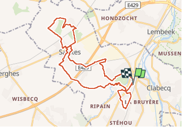
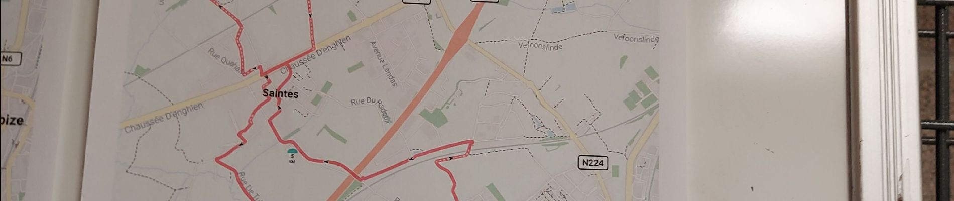
17.1 km | 22 km-effort
4h 56min
![](https://static1.geolcdn.com/siteimages/upload/files/16400158638029165_repeat_loop_refresh_sync_direction_icon.png)
Yes
![Trail Walking Braine-le-Château - RB-Bw-14_Braine-le-Château - Photo](https://media.geolcdn.com/t/375/260/ext.jpg?maxdim=2&url=https%3A%2F%2Fservices.sitytrail.com%2FGeolivesWS%2FDownloadMedia.ashx%3FTrailID%3D179589%26Media%3D13780112-341f-4401-b493-338d7230657e.jpg)
![Walking Walking](https://static1.geolcdn.com/sitytour/trail-icons/101.png)
RB-Bw-14_Braine-le-Château
Walking
Very difficult
(7)
Braine-le-Château,
Wallonia,
Walloon Brabant,
Belgium
![](/images/other/stat-length.png)
23 km | 29 km-effort
6h 30min
![](https://static1.geolcdn.com/siteimages/upload/files/16400158638029165_repeat_loop_refresh_sync_direction_icon.png)
Yes
![Trail Walking Braine-le-Château - RB-Bw-14 - Raccourci 2 - Au nord de Braine-le-Château, à travers de petites réserves naturelles - Photo](https://media.geolcdn.com/t/375/260/ext.jpg?maxdim=2&url=https%3A%2F%2Fstatic1.geolcdn.com%2Fsiteimages%2Fupload%2Ffiles%2F1553511878bg_sport_marche.png)
![Walking Walking](https://static1.geolcdn.com/sitytour/trail-icons/101.png)
RB-Bw-14 - Raccourci 2 - Au nord de Braine-le-Château, à travers de petites r...
Walking
Difficult
(12)
Braine-le-Château,
Wallonia,
Walloon Brabant,
Belgium
![](/images/other/stat-length.png)
11.2 km | 14.9 km-effort
3h 22min
![](https://static1.geolcdn.com/siteimages/upload/files/16400158638029165_repeat_loop_refresh_sync_direction_icon.png)
Yes
![Trail Walking Braine-le-Château - Marche Adeps á Braine-le-Château - Photo](https://media.geolcdn.com/t/375/260/dd34770a-5ca3-45b4-9e04-c11066a91570.jpg&format=jpg&maxdim=2)
![Walking Walking](https://static1.geolcdn.com/sitytour/trail-icons/101.png)
Marche Adeps á Braine-le-Château
Walking
Very easy
(1)
Braine-le-Château,
Wallonia,
Walloon Brabant,
Belgium
![](/images/other/stat-length.png)
10.5 km | 13.7 km-effort
3h 6min
![](https://static1.geolcdn.com/siteimages/upload/files/16400158638029165_repeat_loop_refresh_sync_direction_icon.png)
Yes
![Trail Walking Braine-le-Château - Balade à Braine-le-Château - Photo](https://media.geolcdn.com/t/375/260/ext.jpg?maxdim=2&url=https%3A%2F%2Fservices.sitytrail.com%2FGeolivesWS%2FDownloadMedia.ashx%3FTrailID%3D566873%26Media%3Da3e1e9d2-1e6f-4d9d-bc93-2d87d42c6412.JPG)
![Walking Walking](https://static1.geolcdn.com/sitytour/trail-icons/101.png)
Balade à Braine-le-Château
Walking
Easy
(3)
Braine-le-Château,
Wallonia,
Walloon Brabant,
Belgium
![](/images/other/stat-length.png)
10.8 km | 13.7 km-effort
3h 0min
![](https://static1.geolcdn.com/siteimages/upload/files/16400158638029165_repeat_loop_refresh_sync_direction_icon.png)
Yes
![Trail Walking Rebecq - RB-BW-15-raccourci 1 - Flânerie entre Senne et Coeurcq - Photo](https://media.geolcdn.com/t/375/260/ext.jpg?maxdim=2&url=https%3A%2F%2Fservices.sitytrail.com%2FGeolivesWS%2FDownloadMedia.ashx%3FTrailID%3D221651%26Media%3D1bf86fcb-c1a5-4116-8d1a-312b51935dfd.jpg)
![Walking Walking](https://static1.geolcdn.com/sitytour/trail-icons/101.png)
RB-BW-15-raccourci 1 - Flânerie entre Senne et Coeurcq
Walking
Difficult
(2)
Rebecq,
Wallonia,
Walloon Brabant,
Belgium
![](/images/other/stat-length.png)
13.2 km | 15.9 km-effort
3h 36min
![](https://static1.geolcdn.com/siteimages/upload/files/16400158638029165_repeat_loop_refresh_sync_direction_icon.png)
Yes
![Trail Walking Rebecq - RB-Bw-15_Rebecq - Photo](https://media.geolcdn.com/t/375/260/ext.jpg?maxdim=2&url=https%3A%2F%2Fservices.sitytrail.com%2FGeolivesWS%2FDownloadMedia.ashx%3FTrailID%3D179590%26Media%3D1bf86fcb-c1a5-4116-8d1a-312b51935dfd.jpg)
![Walking Walking](https://static1.geolcdn.com/sitytour/trail-icons/101.png)
RB-Bw-15_Rebecq
Walking
Very difficult
(4)
Rebecq,
Wallonia,
Walloon Brabant,
Belgium
![](/images/other/stat-length.png)
24 km | 29 km-effort
6h 37min
![](https://static1.geolcdn.com/siteimages/upload/files/16400158638029165_repeat_loop_refresh_sync_direction_icon.png)
Yes
![Walking Walking](https://static1.geolcdn.com/sitytour/trail-icons/101.png)
GG2-Bw-23_Hennuyères-Nivelles-provisoire_2021-11-07
Walking
Very difficult
(2)
Braine-le-Comte,
Wallonia,
Hainaut,
Belgium
![](/images/other/stat-length.png)
25 km | 29 km-effort
6h 39min
![](https://static1.geolcdn.com/siteimages/upload/files/16400158638029165_repeat_loop_refresh_sync_direction_icon.png)
No
![Walking Walking](https://static1.geolcdn.com/sitytour/trail-icons/101.png)
#201214 - Braine-le-Château, Les Monts, Les Fonds et Bruyère Landuyt
Walking
Medium
(1)
Braine-le-Château,
Wallonia,
Walloon Brabant,
Belgium
![](/images/other/stat-length.png)
7.8 km | 10.2 km-effort
2h 11min
![](https://static1.geolcdn.com/siteimages/upload/files/16400158638029165_repeat_loop_refresh_sync_direction_icon.png)
Yes