![](/images/other/stat-length.png)
![Trail Walking Le Tholy - Circuit de la Grande Cascade de Tendon - Photo](https://media.geolcdn.com/t/1900/400/ext.pjpeg?maxdim=2&url=https%3A%2F%2Fservices.sitytrail.com%2FGeolivesWS%2FDownloadMedia.ashx%3FTrailID%3D357810%26Media%3Dfix__20141026164307.jpg)
Circuit de la Grande Cascade de Tendon
jeanclaude12
User
![Length](/images/other/stat-length.png)
Length
8.5 km
![Max alt](https://static1.geolcdn.com/siteimages/upload/files/1508320355ic_sort_altitude_max_24dp.png)
Max alt
736 m
![Uphill gradient](https://static1.geolcdn.com/siteimages/upload/files/1508320355ic_sort_den_pos_24dp.png)
Uphill gradient
251 m
![Km-Effort](/images/other/stat-length.png)
Km-Effort
11.8 km
![Min alt](https://static1.geolcdn.com/siteimages/upload/files/1508320355ic_sort_altitude_min_24dp.png)
Min alt
547 m
![Downhill gradient](https://static1.geolcdn.com/siteimages/upload/files/1508320355ic_sort_den_neg_24dp.png)
Downhill gradient
252 m
![Boucle](https://static1.geolcdn.com/siteimages/upload/files/16400158638029165_repeat_loop_refresh_sync_direction_icon.png)
Boucle
Yes
Creation date :
2014-12-10 00:00:00.0
Updated on :
2014-12-10 00:00:00.0
![Walking](https://static1.geolcdn.com/sitytour/trail-icons/101.png)
3h27
Difficulty : Easy
![Scan this QR Code to open this trail in the SityTrail application](https://capi.geolives.com/qq0zvz2zws4bq2lad0pu/sitytour/trails/357810/qr.png?size=200)
FREE GPS app for hiking
About
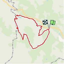
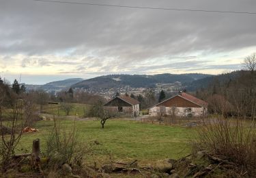
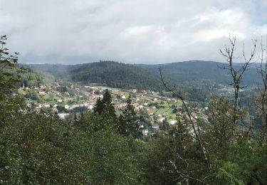
Trail Walking of 8.5 km to be discovered at Grand Est, Vosges, Le Tholy. This trail is proposed by jeanclaude12.
Description
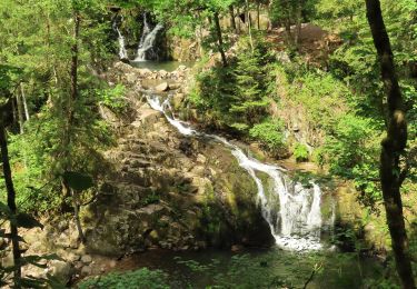
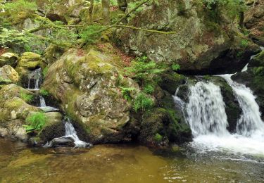
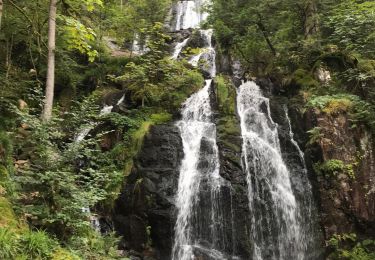
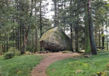
Un peu plus de huit kilomètres depuis le Col de Bonne Fontaine pour se rendre vers le Blanc Faing, la Grande Cascade, l'Infays, le Sapenay et le Gros Caillou.
Positioning
Country:
France
Region :
Grand Est
Department/Province :
Vosges
Municipality :
Le Tholy
Location:
Unknown
Start:(Dec)
Start:(UTM)
330309 ; 5329310 (32U) N.
Comments
Trails nearby
![Trail Walking Tendon - Cascades de Tendon - Trou de l'Enfer - Roches de la Moulure - Photo](https://media.geolcdn.com/t/375/260/6cb30f79-01f0-4a87-b35f-5f5af3475353.jpg&format=jpg&maxdim=2)
![Walking Walking](https://static1.geolcdn.com/sitytour/trail-icons/101.png)
Cascades de Tendon - Trou de l'Enfer - Roches de la Moulure
Walking
Medium
(4)
Tendon,
Grand Est,
Vosges,
France
![](/images/other/stat-length.png)
20 km | 28 km-effort
5h 33min
![](https://static1.geolcdn.com/siteimages/upload/files/16400158638029165_repeat_loop_refresh_sync_direction_icon.png)
Yes
![Horseback riding Horseback riding](https://static1.geolcdn.com/sitytour/trail-icons/301.png)
2022-06-03 Rando CVA Le Tholy Gerbamont
Horseback riding
Very difficult
Le Tholy,
Grand Est,
Vosges,
France
![](/images/other/stat-length.png)
28 km | 41 km-effort
6h 25min
![](https://static1.geolcdn.com/siteimages/upload/files/16400158638029165_repeat_loop_refresh_sync_direction_icon.png)
No
![Trail Horseback riding Le Tholy - 2022-06-02 Rando CVA Le Tholy Tête des Cuveaux - Photo](https://media.geolcdn.com/t/375/260/655700ee-4545-4284-b9be-e2f2446a936f.jpg&format=jpg&maxdim=2)
![Horseback riding Horseback riding](https://static1.geolcdn.com/sitytour/trail-icons/301.png)
2022-06-02 Rando CVA Le Tholy Tête des Cuveaux
Horseback riding
Difficult
Le Tholy,
Grand Est,
Vosges,
France
![](/images/other/stat-length.png)
28 km | 40 km-effort
5h 19min
![](https://static1.geolcdn.com/siteimages/upload/files/16400158638029165_repeat_loop_refresh_sync_direction_icon.png)
Yes
![Horseback riding Horseback riding](https://static1.geolcdn.com/sitytour/trail-icons/301.png)
2022-06-01 Rando CVA Le Tholy Boucle Cascades du Tendon
Horseback riding
Difficult
Le Tholy,
Grand Est,
Vosges,
France
![](/images/other/stat-length.png)
24 km | 34 km-effort
5h 16min
![](https://static1.geolcdn.com/siteimages/upload/files/16400158638029165_repeat_loop_refresh_sync_direction_icon.png)
Yes
![Trail Walking Le Tholy - tendon - Photo](https://media.geolcdn.com/t/375/260/ext.jpg?maxdim=2&url=https%3A%2F%2Fstatic1.geolcdn.com%2Fsiteimages%2Fupload%2Ffiles%2F1553511878bg_sport_marche.png)
![Walking Walking](https://static1.geolcdn.com/sitytour/trail-icons/101.png)
![Trail Walking Le Tholy - Sentier de la Roche Au Blaireau depuis le gîte - Photo](https://media.geolcdn.com/t/375/260/953f411c-aa19-4208-97f3-48d7a7911f9d.jpg&format=jpg&maxdim=2)
![Walking Walking](https://static1.geolcdn.com/sitytour/trail-icons/101.png)
Sentier de la Roche Au Blaireau depuis le gîte
Walking
Medium
Le Tholy,
Grand Est,
Vosges,
France
![](/images/other/stat-length.png)
4.4 km | 6.5 km-effort
1h 25min
![](https://static1.geolcdn.com/siteimages/upload/files/16400158638029165_repeat_loop_refresh_sync_direction_icon.png)
Yes
![Trail Walking Le Tholy - La grande cascade du Tendon au départ du Grand Caillou. - Photo](https://media.geolcdn.com/t/375/260/29f756ea-f122-4fe5-a807-1bae772526aa.jpg&format=jpg&maxdim=2)
![Walking Walking](https://static1.geolcdn.com/sitytour/trail-icons/101.png)
La grande cascade du Tendon au départ du Grand Caillou.
Walking
Difficult
Le Tholy,
Grand Est,
Vosges,
France
![](/images/other/stat-length.png)
9 km | 12.2 km-effort
2h 46min
![](https://static1.geolcdn.com/siteimages/upload/files/16400158638029165_repeat_loop_refresh_sync_direction_icon.png)
Yes
![Trail Walking La Forge - La roche des corbeaux, La Forge - Photo](https://media.geolcdn.com/t/375/260/130216fa-767d-4902-bf97-0a8dff8eb2b3.jpg&format=jpg&maxdim=2)
![Walking Walking](https://static1.geolcdn.com/sitytour/trail-icons/101.png)
La roche des corbeaux, La Forge
Walking
Medium
La Forge,
Grand Est,
Vosges,
France
![](/images/other/stat-length.png)
7.8 km | 11.2 km-effort
2h 33min
![](https://static1.geolcdn.com/siteimages/upload/files/16400158638029165_repeat_loop_refresh_sync_direction_icon.png)
Yes
![Trail Walking Le Tholy - Le trou de l'enfer - Photo](https://media.geolcdn.com/t/375/260/b8b0e984-8b12-439a-8fed-764b95b3aaa2.jpg&format=jpg&maxdim=2)
![Walking Walking](https://static1.geolcdn.com/sitytour/trail-icons/101.png)
Le trou de l'enfer
Walking
Medium
Le Tholy,
Grand Est,
Vosges,
France
![](/images/other/stat-length.png)
10.2 km | 14.2 km-effort
2h 48min
![](https://static1.geolcdn.com/siteimages/upload/files/16400158638029165_repeat_loop_refresh_sync_direction_icon.png)
Yes